Yes, Magic Earth Navigation & Maps is completely free and it doesn't have any in-app purchases or subscriptions.
Is Magic Earth Navigation & Maps legit?
🤔 The Magic Earth Navigation & Maps app seems decent. It has room for improvement but generally satisfies users.
Thanks for the vote
How much does Magic Earth Navigation & Maps cost?
Magic Earth Navigation & Maps is free.
What is Magic Earth Navigation & Maps revenue?
To get estimated revenue of Magic Earth Navigation & Maps app and other AppStore insights you can sign up to AppTail Mobile Analytics Platform.
User Rating
4.57 out of 5
102 ratings in Austria
5 star
78
4 star
14
3 star
2
2 star
2
1 star
5
Ratings History
Magic Earth Navigation & Maps Reviews
Downgraded features
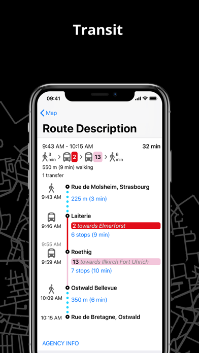
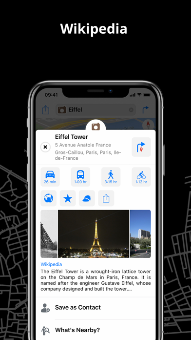
The app was great but the newer version still doesn’t have features that I used a lot and are still missing from this “improved” app: Wikipedia links, public transportation showing the end destination station for the bus/ metro you take. Should I take the bus line A10 and go which direction? To A10 North or A10 South? The app just says A10
Please add Wikipedia to new App
Hi Magic Earth. I always liked your app and still do. Can you do me a favor and provide links to Wikipedia articles like you did in the previous version of the app? Many thanks.
Top app!
Best free Navi app out there. I ditched tomtom for it.
There are few thing that could improved though: show one more “next turn/exit”, to improve highways navigation, sometimes it shows the turn and then when it switches to next one, it’s already too late, if there close to each other.
Second thin, which I’ve never seen in any app, is make exclusions for “Avoid toll roads”. I live in Austria and I have a vignette for Austrian roads, and I would like to avoid tolls only when I go abroad to another neighboring country 😇
Leider nicht aktuell/ nicht hochauflösend Satellitenkarten
Adresse wird irgendwo auf dem Feldweg angezeigt was falsch ist. Auserdem ist die Satellitenkarte nicht hochauflösend und nicht aktuell. Das einzige was für Magic Earth spricht ist offline karten weltweit.
Hammer-App und ein paar Fragen
Diese Navi-App ist wirklich super gelungen, was stört ist der fehlende automatische Zoom bei höheren Geschwindigkeiten. Das Bild mit Strassen wird besonders am Carplay-Monitor zu groß dargestellt. Man kann manuell auszoomen, das aber bei jedem Start.
Bezieht sich die Profileinstellung LKW z.B. nur auf die Geschwindigkeit oder auch auf die Navigation, zb bei Brückendurchfahrten mit Höhenangabe?
Bin Busfahrer, diese App ist die einzige, die mir richtig gut gefällt
Beste zur Zeit
Beste App für Navigation 👍🏻👍🏻👍🏻und kostenlos danke dafür 😘👍🏻
Es fehlt nur eines noch MOTORRAD ROUTEN Berechnung!————————————————————
Best app for navigation 👍🏻👍🏻👍🏻and free thanks for that 😘👍🏻
Only one MOTORCYCLE ROUTE calculation is missing!!
Superb
Ein gelungener Neustart.
Sehr schönes neues Icon auch.
Please add back features to new App
Hi Magic Earth. I always liked your app and still do, however, please add some features to your new app that I always found very useful: 1. Please provide links to Wikipedia articles. 2. Please allow checking routes for traffic information, profile etc. 3. Please allow seeing the results of a search on the map. 4. Please allow switching off of automatic start of navigation. Many thanks.
New Version missing Functions
Dear ME Team,
respect for all your efforts but please provide back the old Version and build in all functions from this into the new App.
Sorry to say the new App is not usable yet for planing and driving.
- Auto Switch 2d/3d view missing
- Autostart off switch
- review suggested Routes
- Night/Day auto switch
etc etc etc
downgrades in latest Update!
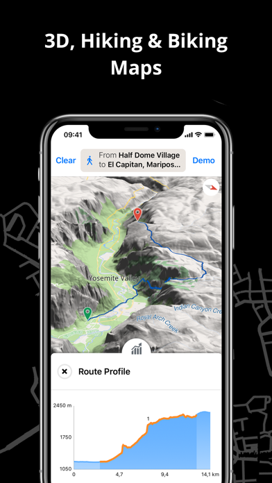
While the latest updates brings a refreshed, modernized look and support for many new map styles it also secretly dropped useful features like the topological route profile. The built in route profile was one of the reason for choosing Magic Earth over other similar apps.
A feature I requested several years ago - the possibility to save and share routes in iCloud/with other users - is still missing. Can it be THAT difficult to implement a coordinate list of stops to be saved for sharing among devices and people?
The app mixes default English with other (device-specific) languages which is confusing.
Despite being on very fast connection streaming of map data for certain 3D maps ist incredibly slow, making navigation almost impossible.
Disappointed!!
This page includes copyrighted content from third parties, shared solely for commentary and research in accordance with fair use under applicable copyright laws. All trademarks, including product, service, and company names or logos, remain the property of their respective owners. Their use here falls under nominative fair use as outlined by trademark laws and does not suggest any affiliation with or endorsement by the trademark holders.