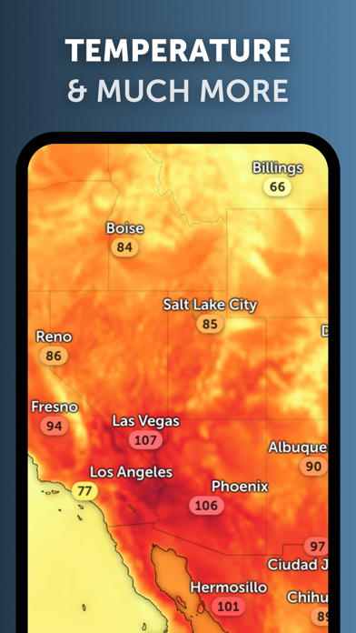
SpeechX-естественный звук

Hurricane Tracker, Rain Map

Published by: Neave Interactive

Description

INTERACTIVE WEATHER MAP
Zoom Earth is an interactive weather map of the world and a real-time hurricane tracker.
Explore the current weather and see forecasts for your location through interactive weather maps of rain, wind, temperature, pressure, and more.
With Zoom Earth, you can track the development of hurricanes, storms, and severe weather, monitor wildfires and smoke, and stay aware of the latest conditions by viewing satellite imagery updated in near real‑time.

SATELLITE IMAGERY
Zoom Earth shows weather maps with near real-time satellite imagery. Images are updated every 10 minutes, with a delay between 20 and 40 minutes.
Live satellite images are updated every 10 minutes from NOAA GOES and JMA Himawari geostationary satellites. EUMETSAT Meteosat images are updated every 15 minutes.
HD satellite images are updated twice a day from NASA polar-orbiting satellites Aqua and Terra.

WEATHER FORECAST MAPS
Explore beautiful, interactive visualizations of the weather with our stunning global forecast maps. Our maps are continually updated with the latest weather forecast model data from DWD ICON and NOAA/NCEP/NWS GFS. Weather forecast maps include:
Precipitation Forecast - Rain, snow, and cloud cover, all in one map.
Wind Speed Forecast - Average speed and direction of surface winds.
Wind Gusts Forecast - Maximum speed of sudden bursts of wind.
Temperature Forecast - Air temperatures at 2 meters (6 feet) above the ground.
"Feels Like" Temperature Forecast - Perceived temperatures, also known as apparent temperature or heat index.
Relative Humidity Forecast - How air moisture compares to temperature.
Dew Point Forecast - How dry or humid the air feels, and the point at which condensation occurs.
Atmospheric Pressure Forecast - The average atmospheric pressure at sea level. Low-pressure areas often bring cloudy and windy weather. High-pressure areas are associated with clear skies and lighter winds.

HURRICANE TRACKING
Follow hurricanes from development to category 5 in real-time with our best-in-class tropical tracking system. Information is clear and easy to understand. Our hurricane tracking weather maps are updated using the very latest data from NHC, JTWC, NRL, and IBTrACS.

WILDFIRE TRACKING
Monitor wildfires with our active fires and heat spots overlay, which shows points of very high temperature detected by satellite. Detections are updated daily with data from NASA FIRMS. Use in conjunction with our GeoColor satellite imagery to see the movement of wildfire smoke and monitor fire weather in near real-time.

CUSTOMIZATION
Adjust temperature units, wind units, time zone, animation styles, and many more features with our comprehensive settings.

ZOOM EARTH PRO
More features are available through auto-renewable subscriptions. Payment will be charged to your App Store account at the confirmation of purchase. The subscription will automatically renew at the end of each billing period and be charged within 24 hours, unless auto-renew is turned off at least 24 hours before the end of the current period. For further information, please read our Terms of Service.

LEGAL
Terms of Service: https://zoom.earth/legal/terms/
Privacy Policy: https://zoom.earth/legal/privacy/
Hide Show More...

In-Apps

Zoom Earth Pro
$8.99

Screenshots

SpeechX FAQ

  • Is SpeechX free?

    Yes, SpeechX is free to download, however it contains in-app purchases or subscription offerings.

  • Is SpeechX legit?

    🤔 The SpeechX app's quality is mixed. Some users are satisfied, while others report issues. Consider reading individual reviews for more context.

    Thanks for the vote

  • How much does SpeechX cost?

    SpeechX has several in-app purchases/subscriptions, the average in-app price is $8.99.

  • What is SpeechX revenue?

    To get estimated revenue of SpeechX app and other AppStore insights you can sign up to AppTail Mobile Analytics Platform.

User Rating

4.86 out of 5

31,046 ratings in United States

5 star
27,798
4 star
2,006
3 star
515
2 star
133
1 star
236
Ratings History

SpeechX Reviews

Weather app

bigw7591 on

United States

So far so good

Life saver

flowergirl0326 on

United States

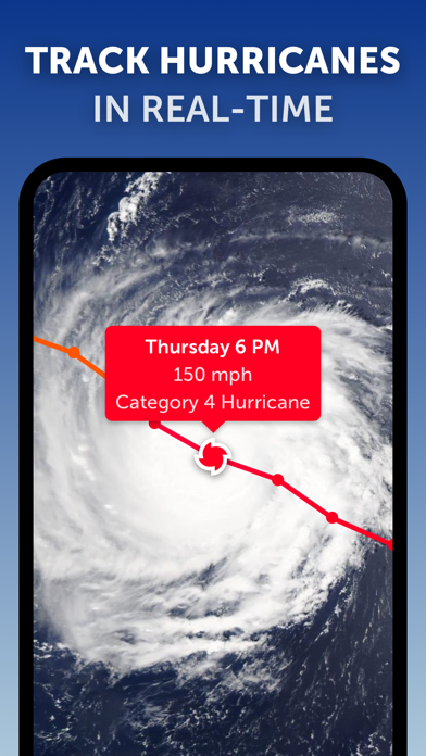
This truly was a life saver during hurricane Helene! I was able to help my son know when it was about to be over his place which was in Valdosta Ga. That area was hit pretty Badly. This allows you to track the path of storm so well, it’s really amazing.

A little confusing to start

Hollsshay on

United States

It was just a little confusing how to see things at first but it is a good app

Great app

Surfpunk777 on

United States

This app is amazing!

Remark

Check awaseru on

United States

Not so accurate anymore in my zone

Fun and Satisfying

lucida sidera on

United States

Just got it and so far I love it!

Very good

Johnjjjjjjsssss on

United States

It is a great app

A lil laggy

ThatOneGoofyToast on

United States

Just a lil laggy and a bit slow i forgot to add that.

ARTIFICIAL SIMULATION!

Da’WRECKINGBALL on

United States

3rd PARTY LEACHERS SELLING GOVERNMENT FUNDED NOAA’S WEBSITE INFORMATION TO STUPID CITIZENS WHO VIEW FALSE DATA! NEVER UP TO THE MINUTE VIEW, TARDY LIKE AN IMMATURE CHILD!

A Very Human Way of Seeing The Westher

BurntGlass on

United States

Without graphs and tables this wonderful continuation of the Zoom Earth pre GoogleMaps project, projects the weather in the most accessible way. Thank you people for making it so.

Store Rankings

Ranking History
Category Rankings
Chart
Category
Rank
Top Free
2
Top Grossing
5
Top Free
5
Top Free
5
Top Free
6

Keywords

SpeechX Competitors

Zoom Earth Installs

Last 30 days

Zoom Earth Revenue

Last 30 days

SpeechX Revenue and Downloads

Gain valuable insights into Zoom Earth performance with our analytics.
Sign up now to access downloads, revenue, and more.
This page includes copyrighted content from third parties, shared solely for commentary and research in accordance with fair use under applicable copyright laws. All trademarks, including product, service, and company names or logos, remain the property of their respective owners. Their use here falls under nominative fair use as outlined by trademark laws and does not suggest any affiliation with or endorsement by the trademark holders.