3D Offline Maps: GPS tracker

Blutzucker & Herzgesundheit

Veröffentlicht von: SERGEI BEZDENEZHNYKH

Beschreibung

Detailed 2D and 3D maps, with the ability to download maps for offline navigation and comfortable travel without an Internet connection anywhere in the world!
Choose and save your routes, create a collection of tracks with waypoints, share with friends, mark interesting places on the map, download ready-made tracks and waypoints in GPX format.
Create, import, export tracks with waypoints. Offline map support, no time limits, no ads.
The main functions of the application:
- compatible with Apple Silicon MacBook.
- work in the background.
- convenient and accelerated loading of maps.
- route planner.
- pedometer with viewing data for the last three months (steps, distance).
- determining the height of any waypoint.
- search by address.
- search by coordinates.
- compass.
- barometer.
- processing and optimization of tracks.
- Linking tracks to the road network.
- Downloading and unlimited storage of travel area maps.
- Supports all methods of import and export with services, friends and applications in .gpx format available for your device.
- Color gradient for speed and altitude, if this information is in the imported track.
- Color gradient for speed and altitude for recorded tracks.
- Recording speed and altitude in the track.
- Terrain contours in outdoor mode
- Extended track information: average and maximum speed, track duration by time and distance, number of waypoints and number of steps.
- Different units of measurement: miles, kilometers, feet, meters.
- Viewing one or more tracks in any application mode, including the mode of recording another track.
- Setting, editing, deleting waypoints in any application mode and in any place.
- Custom icons for waypoints.
- the ability to customize the track quality, distance filters, power saving mode.
- export and import tracks and waypoints to various services - Open Street Map and others.
- has a pointer to the target waypoint and shows the distance to it. Easy selection of the target waypoint in several ways.
- display additional information on the screen - scale, coordinates, altitude, speed, number of steps.
- shows the current distance traveled track and the time on the road or walk.
- has several map styles - satellite, streets, combined and dark.
- supports the dark theme.
- easy start and stop tracking in several ways.
- the ability to continue any previously recorded or imported track.
- several modes of map orientation - by phone title, by direction of travel, centering and north.
- the ability to tilt the map with a double pinch.
- quick and easy selection and viewing of saved tracks, waypoints and maps.
- speed and altitude graphs can be scaled and scrolled.
- in the settings there is a link to the user manual.
- Terms of Service: https://appsupport.store/terms/
- Privacy Policy: https://appsupport.store/privacy
Ausblenden Mehr anzeigen...

Screenshots

3D Offline Maps Häufige Fragen

  • Ist 3D Offline Maps kostenlos?

    Ja, 3D Offline Maps ist komplett kostenlos und enthält keine In-App-Käufe oder Abonnements.

  • Ist 3D Offline Maps seriös?

    🤔 Die 3D Offline Maps-App scheint anständig zu sein. Es gibt Raum für Verbesserungen, aber im Allgemeinen sind die Nutzer zufrieden.

    Danke für die Stimme

  • Wie viel kostet 3D Offline Maps?

    3D Offline Maps ist kostenlos.

  • Wie hoch ist der Umsatz von 3D Offline Maps?

    Um geschätzte Einnahmen der 3D Offline Maps-App und weitere AppStore-Einblicke zu erhalten, können Sie sich bei der AppTail Mobile Analytics Platform anmelden.

Benutzerbewertung

3.83 von 5

6 Bewertungen in Nepal

Bewertungsverlauf

3D Offline Maps Bewertungen

Я

Olgusa6 on

Russland

Супер

Отличное приложение

Алекса 0713 on

Russland

Супер

Отличный навигатор

NPZ-SK on

Russland

Лучший доступный навигатор для леса за разумную плату из того что я перепробовал.

С чем связано ограничение по размеру карт

Aramagedin on

Russland

Интересное приложение, но не понятно ограничения по загружаемым картам.

Навигатор

Яйца 66 on

Russland

Спасибо за навигатор

Лучший трекер

Hunter555s on

Russland

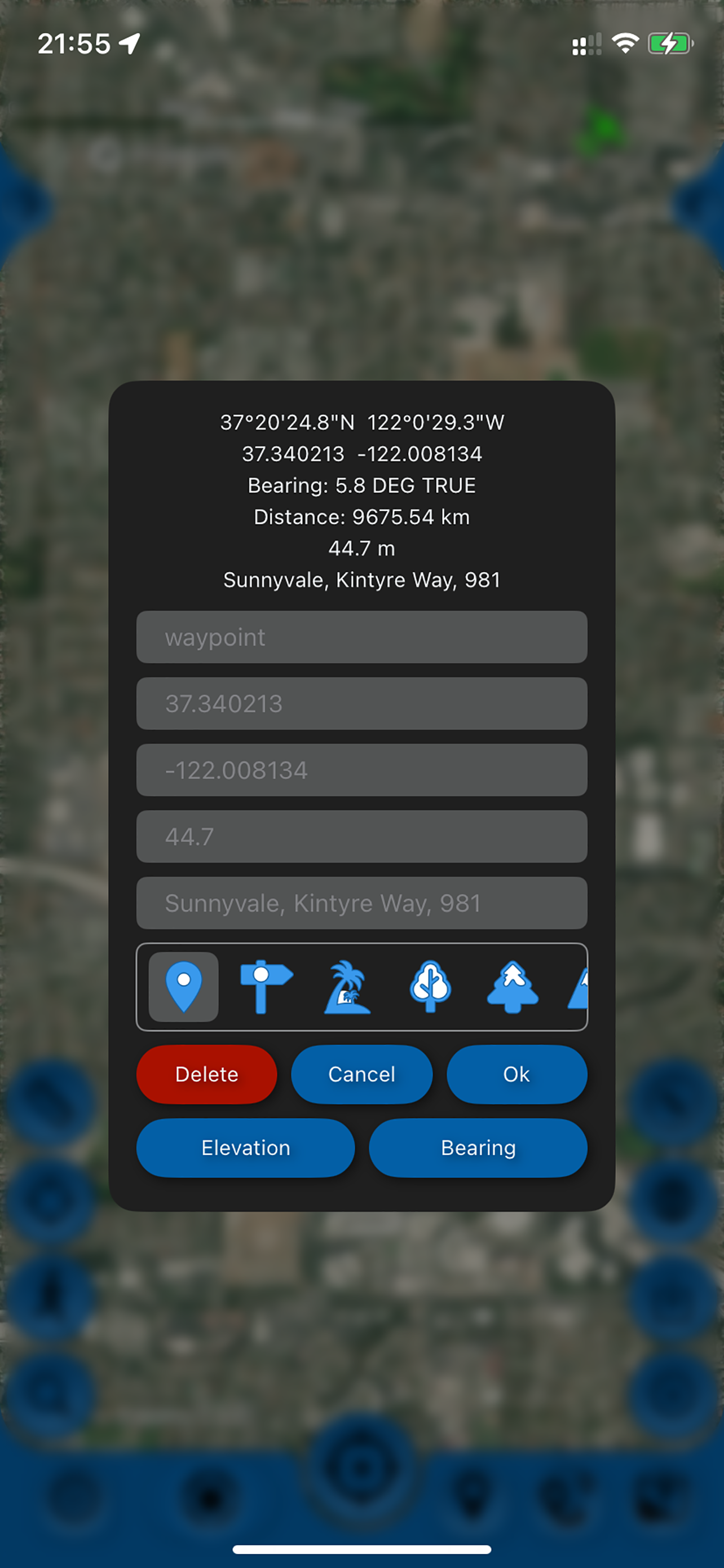
Лучший трекер для охоты и рыбалки. Записал трек дороги на рыбалку, поделился с друзьями. Их приложения трек поняли, видимо формат стандартный. Офлайн работает, трек пишет с выключенным экраном, качеством трека доволен. Все отлично, недорого. Хотелось бы дополнительные иконки для путевых точек, типа - дом, авто, палатка, место охоты, рыбалки, грибное место, костер. Да просто с десяток разных значков.

Супер

Александр85/15 on

Russland

Отличное предложение. Давно пользуюсь давно.

Оплата

псевдоним? вообще-то имя есть on

Russland

Как оплатить? Оплата не работает.

Отзыв

76Tasha on

Russland

Прикольно, 3д трек позволяет оценить, как проходит тропа в горах со всех сторон и работает офлайн. Часто пользуюсь

Отзыв о приложении

Nata_45 on

Russland

Давно пользуемся, хорошее удобное приложение, все работает отлично! Для путешествий самое то, есть семейная подписка. Спасибо.

Store-Rankings

Ranking-Verlauf
App-Ranking-Verlauf noch nicht verfügbar
Kategorien-Rankings
Diagramm
Kategorie
Rang
Top Umsatz
23
Top Umsatz
34
Top Umsatz
36
Top Umsatz
40
Top Umsatz
42

3D Offline Maps Installationen

Letzte 30 Tage

3D Offline Maps Umsatz

Letzte 30 Tage

3D Offline Maps Einnahmen und Downloads

Gewinnen Sie wertvolle Einblicke in die Leistung von 3D Offline Maps mit unserer Analytik.
Melden Sie sich jetzt an, um Zugriff auf Downloads, Einnahmen und mehr zu erhalten.
This page includes copyrighted content from third parties, shared solely for commentary and research in accordance with fair use under applicable copyright laws. All trademarks, including product, service, and company names or logos, remain the property of their respective owners. Their use here falls under nominative fair use as outlined by trademark laws and does not suggest any affiliation with or endorsement by the trademark holders.