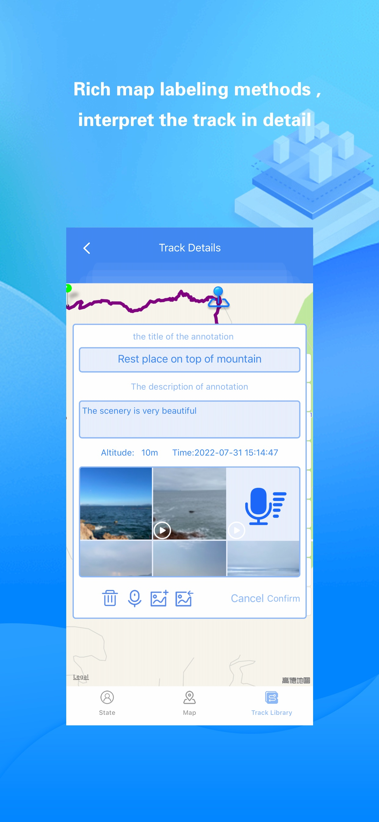
Share Track

Sports, travel and photography

Beschreibung

"Share Track" can record and share information such as travel routes, vehicle driving routes, and motion tracks according to user needs:
It is compact and compact, easy to operate.
“Share Track” has rich map annotation methods,it can use voice, text, video, photos and hand painted photos to mark any place on the map.
The imported/exported track data format is rich and compatible with various map software.
Adaptive to various track types (cycling, self-driving, hiking, etc.) and switching, eliminating the trouble of determining the type of motion in advance.
Automatically correct the track points very rigorously to ensure the accuracy of the track.
"Share Track" can closely combine videos, photos and track data to provide users with different sports and travel experiences:
You can include videos, photos and voices in the mobile phone album into the track data, and share with other friends with one click.
Videos/photos taken by the user during track recording can be loaded with one click. Depending on the geographic location of the Videos/photos, the videos/photos will automatically be displayed on the map with the track.
Photos/videos in mobile phone albums and recorded voices can be marked on the map to form rich annotations for tracks.

If you have “Share Track":
You can use Google Earth software to browse the travel routes, vehicle driving routes and motion tracks recorded by "Share Track" in the 3D scene, and you can also send track data to your friends' mobile phones through instant messaging tools such as FaceBook and Twitter.
You can include videos, photos and voices in the mobile phone album into the track data, and share with other friends with one click. Your friends can enjoy your shared videos and photos on the map simply by importing the track files you shared into "Share Track".
You can always enjoy the videos and photos of each trip on the map and relive the good memories.
You can view your altitude, speed and direction in real time while running or traveling outdoors.
You can make informative road books (including videos, photos, voices, tracks, etc.) to offer to your friends.
You can get real-time guidance to your destination through the track navigation function.
It is a tool related to track,track recording,footprint,cycling,outdoor,hiking,running,walking,driving,map,travel,navigation,mountaineering and other activities.
Ausblenden Mehr anzeigen...

In-App-Käufe

Share Track VIP
$2.99

Screenshots

Share Track Häufige Fragen

  • Ist Share Track kostenlos?

    Ja, Share Track ist kostenlos herunterzuladen, enthält jedoch In-App-Käufe oder Abonnements.

  • Ist Share Track seriös?

    ✅ Die Share Track-App scheint von hoher Qualität und legitim zu sein. Die Nutzer sind sehr zufrieden.

    Danke für die Stimme

  • Wie viel kostet Share Track?

    Share Track bietet mehrere In-App-Käufe/Abonnements, der durchschnittliche In-App-Preis beträgt 2.99 $.

  • Wie hoch ist der Umsatz von Share Track?

    Um geschätzte Einnahmen der Share Track-App und weitere AppStore-Einblicke zu erhalten, können Sie sich bei der AppTail Mobile Analytics Platform anmelden.

Benutzerbewertung
Die App ist in Vereinigte Staaten noch nicht bewertet.
Bewertungsverlauf

Share Track Bewertungen

改版后,非常好

终极者 on

China

有地图标注功能

真棒‏‌ 

时夏ω忆思 on

China

一直用分享轨迹玩户外,谢谢分享轨迹将户外先行者的足迹留下,让我们依轨而行,真心谢谢‍  ‌ ‍‌  

不错的软件,户外还是很好使的。 ‎‎​    ‍

o主持人鹿鸣 on

China

不错的软件,户外还是很好使的。现在出行必备吧!​ ‍‏ ‎‏

轨迹功能最喜欢 ‏    

Fawn Dobson on

China

最喜欢最需要的就是轨迹功能,记录自己的轨迹,分享。浏览别人的轨迹。   ‏‍ ‍   ‍  

好用 ‌​

不再依♂然 on

China

实用好用太喜欢用这个软件了,强烈推荐,  ‏

很好用 ‏ 

约定真爱 on

China

确实很不错,细小的路线都能显示,又能及时更新。    ‍

户外好帮手‏  

Ashely Evita on

China

我喜欢这个软件。轨迹功能很棒!谢谢!  ‎

优秀  ‏

?宇彬 on

China

一个不错的软件,用了很多年了‎‏ 

实用  ​

专属小小小︶女人 on

China

不错,真的太好用了 ​‎

户外出行必备‎​ 

Fatima_Armandah on

China

很好的一款户外软件  ​

Store-Rankings

Ranking-Verlauf
App-Ranking-Verlauf noch nicht verfügbar
Kategorien-Rankings
Diagramm
Kategorie
Rang
Top Kostenlos
220
Top Kostenlos
435
Top Kostenlos
442

Schlüsselwörter

Share Track Konkurrenten

Name
PlanARouteLite
Multi-stop routing made easy.
Terra Map - Trail Explorer
Outdoor trails & topo charts
Route Maker - Route Planner
Travel and Business Route Plan
GPS Tracker: Offline Maps, GPX
Navigation, Compass, Pedometer
Footprint on Map
Automatically record places
FootPrint-Record travel tracks
Automatically record footprint
FootPrint - Record Life's Path
极致省电后台自动记录GPS轨迹
RouteHistory
Record and display routes
Logistics Mobile
Journey GPS Tracker
Hiking Cycling Location Logger

分享轨迹 Installationen

Letzte 30 Tage

分享轨迹 Umsatz

Letzte 30 Tage

Share Track Einnahmen und Downloads

Gewinnen Sie wertvolle Einblicke in die Leistung von 分享轨迹 mit unserer Analytik.
Melden Sie sich jetzt an, um Zugriff auf Downloads, Einnahmen und mehr zu erhalten.

App-Informationen