Beschreibung
- Visualize seismic hotspots on an interactive HeatMap
- Updated every minute for accurate visualization
- Intuitive interface for easy navigation
Discover Real-time Earthquakes with LiveMAP:
- Explore live seismic activity worldwide
- Real-time data updates from FDSN
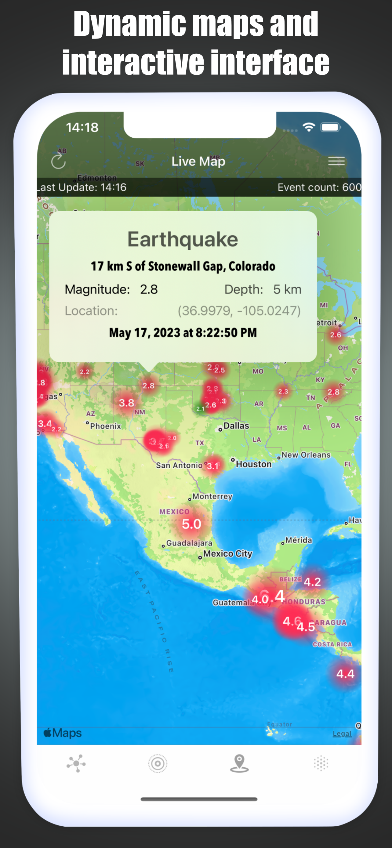
- Dynamic maps and interactive interface
- Engage with the latest seismic events
Personalized Earthquake Experience:
- Set filters based on magnitude, and event type
- Stay connected with real-time updates and information
- User-friendly interface for a seamless experience
Uncover Earthquake History with History Section:
- Dive into centuries of earthquake records
- Access comprehensive data from 2150 B.C. to present
- Visualize historical earthquakes on an interactive map
- Learn about destructive earthquakes and their impact
Targeted for Researchers, Nature Enthusiasts, and Emergency Managers:
- Designed for earthquake researchers and scientists
- Perfect for nature enthusiasts interested in seismic activity
- Essential tool for emergency managers and preparedness
- Tailored features to meet professionals' needs
Visualize Earthquakes with Interactive Maps:
- Engage with captivating maps displaying earthquake data
- Zoom in and explore specific regions or cities
- Filter seismic activity by magnitude, event type
- Get a comprehensive view of global seismic activity
Reliable Data from Trusted Sources:
- Live data sourced directly from FDSN and USGS
- Accurate and up-to-date seismic information
- Extensive earthquake database with records and statistics
- Trustworthy source for researchers and professionals
- Dependable insights for decision-making
HEATMAP Section:
- Real-time data from USGS generates a dynamic HeatMap
- Instantly visualize seismic activity on the map
- Intuitive and up-to-date overview of earthquakes
- Continuous updates ensure the latest information availability
- Comprehensive overview of seismic activity in the past month
- Seismic activities with magnitude 1 or higher from the past month
LIVE Section:
- Real-time data retrieval of seismic activities with magnitude 2.5 or higher from the past month (USGS)
- Continuous updates every 1 minute with dynamic lists and maps
- Detailed information on each earthquake, including distance, coordinates, magnitude, depth, and timing
- Direct link to USGS page for further information
- Magnitude filtering for customized earthquake display
LIVEMAP Section:
- Real-time retrieval and processing of event type data from the internet
- Categorized event types assigned by FDSN
- Selection and display of filtered activities on the real-time map
- Additional magnitude filtering with minimum and maximum values
- Automatic synchronization every minute with manual option
- Display of last synchronization time and event count
Screenshots
Earthquake Maps Häufige Fragen
-
Ist Earthquake Maps kostenlos?
Ja, Earthquake Maps ist komplett kostenlos und enthält keine In-App-Käufe oder Abonnements.
-
Ist Earthquake Maps seriös?
Nicht genügend Bewertungen, um eine zuverlässige Einschätzung vorzunehmen. Die App benötigt mehr Nutzerfeedback.
Danke für die Stimme -
Wie viel kostet Earthquake Maps?
Earthquake Maps ist kostenlos.
-
Wie hoch ist der Umsatz von Earthquake Maps?
Um geschätzte Einnahmen der Earthquake Maps-App und weitere AppStore-Einblicke zu erhalten, können Sie sich bei der AppTail Mobile Analytics Platform anmelden.

1 von 5
1 Bewertungen in Algerien

Earthquake Maps Bewertungen
Store-Rankings


|
Diagramm
|
Kategorie
|
Rang
|
|---|---|---|
|
Top Kostenlos
|

|
200
|
|
Top Kostenlos
|

|
205
|
|
Top Kostenlos
|

|
329
|
|
Top Kostenlos
|

|
364
|
|
Top Kostenlos
|

|
373
|
Schlüsselwörter
Erdbeben LIVE Installationen
Letzte 30 TageErdbeben LIVE Umsatz
Letzte 30 TageEarthquake Maps Einnahmen und Downloads
Melden Sie sich jetzt an, um Zugriff auf Downloads, Einnahmen und mehr zu erhalten.
App-Informationen
- Kategorie
- Reference
- Herausgeber
- tamer bayramogullari
- Sprachen
- Spanish, German, Catalan, Czech, Chinese, Korean, Croatian, Danish, Slovak, Finnish, French, Greek (modern), Hebrew (modern), Hindi, Hungarian, Indonesian, English, Italian, Japanese, Malay, Dutch, Norwegian Bokmål, Polish, Portuguese, Romanian, Russian, Swedish, Thai, Turkish, Ukrainian, Vietnamese, Arabic
- Letzte Veröffentlichung
- 3.3 (vor 1 Jahr )
- Veröffentlicht am
- Mar 17, 2020 (vor 4 Jahren )
- Auch verfügbar in
- Deutschland, Algerien, Ukraine, Frankreich, China, Ungarn, Kasachstan, Ecuador, Estland, Spanien, Italien, Japan, Dänemark, Niederlande, Peru, Pakistan, Polen, Russland, Saudi-Arabien, Singapur, Usbekistan, Brasilien, Argentinien, Österreich, Australien, Aserbaidschan, Belgien, Bulgarien, Bahrain, Brunei Darussalam, Dominikanische Republik, Belarus, Kanada, Schweiz, Chile, Kolumbien, Zypern, Tschechien, Vereinigte Arabische Emirate
- Zuletzt aktualisiert
- vor 2 Wochen
- © 2025 AppTail.
- Unterstützung
- Privacy
- Terms
- All Apps


