Beschreibung
Mierz ziemię, drogi, parki, kraje, jeziora itp. Oblicza odległości, obszary i obwody.
Funkcje, które ta aplikacja oferuje, że większość konkurentów nie:
- Dodać niestandardowe jednostki odległości i powierzchni.
- Rysowanie wielokątów wnętrza. Na przykład obszar lądowy z wody usuwane.
- Dodać punkt na środku ścieżki (większość tylko umożliwiają dodawanie do końca ścieżki) Naciśnij, aby dodać na końcu ścieżki. Naciśnij długo, aby dodać w środku ścieżki.
- Zamienić dwa punkty w ścieżkę lub Wielokąt.
- Dodać bieżącą z odbiornika GPS.
Funkcje:
- 3 opcji warstwy mapy
- Eksport i import plików .kml za pośrednictwem Dropbox, iCloud, e-mail, itp
- Piny można przeciągać i edytować ręcznie
- Nazwa, zauważa, a kolor pola dla każdej ścieżki i Wielokąt
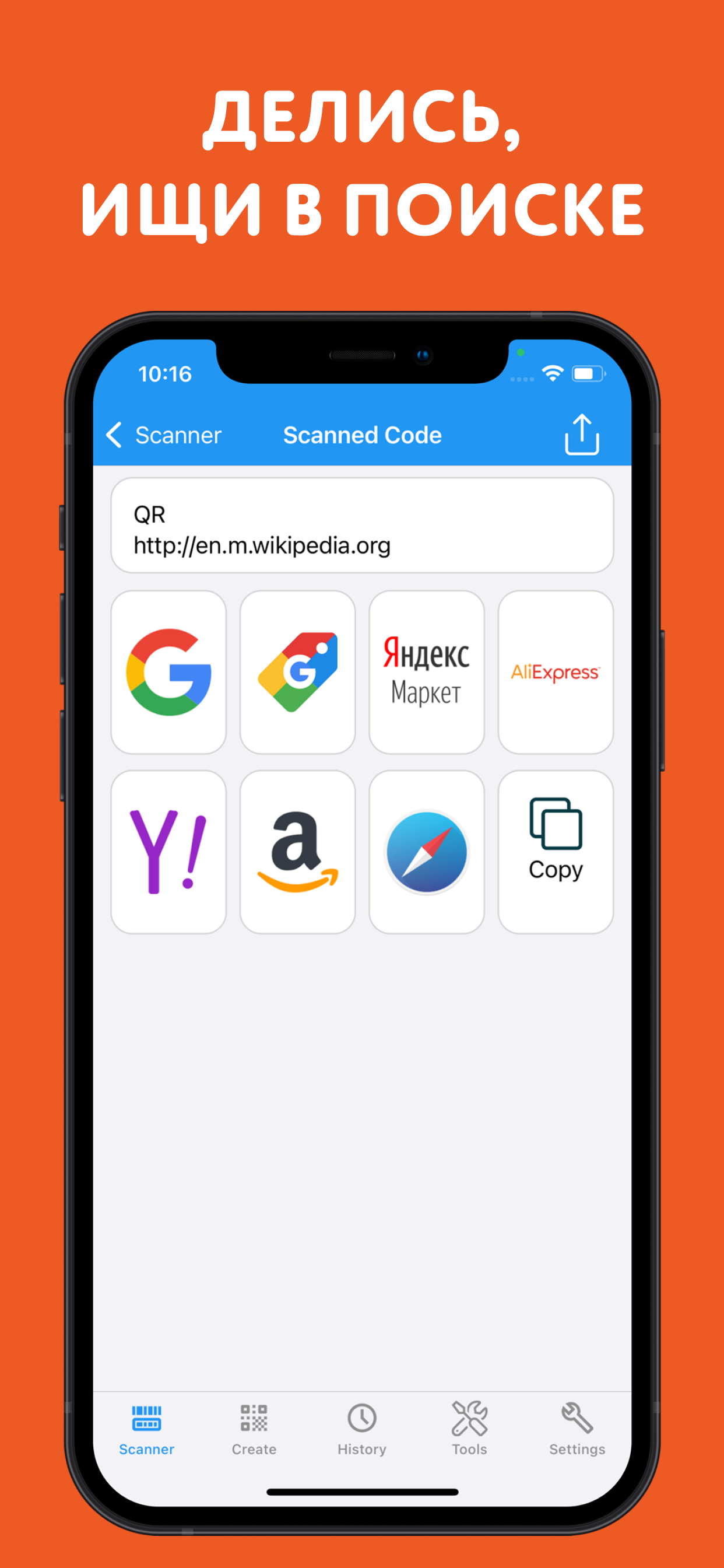
- Wysłał lub dane tekstowe wiadomości ścieżki i Wielokąt
- 4 tryby szczegółowości. Wyświetlić tylko te informacje, które chcesz zobaczyć
- Wyszukiwanie po kod pocztowy, miasto, adres, itp
- Get adresy w pobliżu point na mapie
4 tryby rysunek:
- Ścieżka
- Wielokąt
- Wielokąt z pustych miejsc wewnątrz
- Brak trybu edycji (aby zapobiec przypadkowej zmiany)
Wartości wyświetlane dla ścieżki:
- Całkowita odległość
- Odległość dla każdej trasy
Wartości wyświetlane dla wielokątów:
- Obszar
- Obwód
- Odległość dla każdej strony
Dodać punkty do ścieżkę lub Wielokąt w 1 4 sposoby:
- Dotknij na mapie
- Użyj bieżącej lokalizacji
- Ręcznie wprowadzić współrzędne
- Plik Importuj .kml
Domyślne jednostki odległości obejmują:
- Miernik
- Stopa
- Stoczni
- Kilometr
- Mile
- Mil
Domyślnymi jednostkami obszaru obejmują:
- Metrowy
- Metrową
- Jard kwadratowy
- Km²
- Square mile
- Square mile morskie
- Akr kwadrat
- Ha kwadrat
Formatów współrzędnych:
- Stopnie
- Stopnie, minuty
- Stopnie, minuty, sekundy
- UTM/UPS (uniwersalny Transverse Mercator)/(Universal Polar stereograficzny)
- MGRS (wojskowy system referencyjny siatki)
English:
Measure land, roads, parks, countries, lakes, etc from a satellite view. Calculates distances, areas, and perimeters.
Features that this application offers that most competitors do not:
- Add custom distance and area units.
- Draw interior polygons. For example, land area with bodies of water removed.
- Add a point to the middle of a path (Most only allow you to add to the end of the path) Tap to add to the end of a path. Long press to add to the middle of a path.
- Swap two points in a path or polygon.
- Add your current location from GPS receiver.
Features:
- 3 map layer options
- Export and import .kml files via Dropbox, iCloud, email, etc
- Pins are draggable and manually editable
- Name, notes, and color fields for each path and polygon
- Email or text message path and polygon data
- 4 verbosity modes. See only the information that you want to see
- Search by postal code, city, address, etc
- Get addresses near point on map
4 drawing modes:
- Path
- Polygon
- Polygon with hollow spaces inside
- No edit mode (to prevent accidental edits)
Values displayed for paths:
- Total distance
- Incremental distance for each waypoint
Values displayed for polygons:
- Area
- Perimeter
- Distance for each side
Add points to a path or polygon in 1 of 4 ways:
- Tap on the map
- Use current location
- Enter coordinates manually
- Import .kml file
Default distance units include:
- Meter
- Foot
- Yard
- Kilometer
- Mile
- Nautical mile
Default area units include:
- Square meter
- Square foot
- Square yard
- Square kilometer
- Square mile
- Square nautical mile
- Square acre
- Square hectare
Coordinate formats:
- Degrees
- Degrees, minutes
- Degrees, minutes, seconds
- UTM / UPS (Universal Transverse Mercator) / (Universal Polar Stereographic)
- MGRS (Military Grid Reference System)
Ausblenden
Mehr anzeigen...
Funkcje, które ta aplikacja oferuje, że większość konkurentów nie:
- Dodać niestandardowe jednostki odległości i powierzchni.
- Rysowanie wielokątów wnętrza. Na przykład obszar lądowy z wody usuwane.
- Dodać punkt na środku ścieżki (większość tylko umożliwiają dodawanie do końca ścieżki) Naciśnij, aby dodać na końcu ścieżki. Naciśnij długo, aby dodać w środku ścieżki.
- Zamienić dwa punkty w ścieżkę lub Wielokąt.
- Dodać bieżącą z odbiornika GPS.
Funkcje:
- 3 opcji warstwy mapy
- Eksport i import plików .kml za pośrednictwem Dropbox, iCloud, e-mail, itp
- Piny można przeciągać i edytować ręcznie
- Nazwa, zauważa, a kolor pola dla każdej ścieżki i Wielokąt
- Wysłał lub dane tekstowe wiadomości ścieżki i Wielokąt
- 4 tryby szczegółowości. Wyświetlić tylko te informacje, które chcesz zobaczyć
- Wyszukiwanie po kod pocztowy, miasto, adres, itp
- Get adresy w pobliżu point na mapie
4 tryby rysunek:
- Ścieżka
- Wielokąt
- Wielokąt z pustych miejsc wewnątrz
- Brak trybu edycji (aby zapobiec przypadkowej zmiany)
Wartości wyświetlane dla ścieżki:
- Całkowita odległość
- Odległość dla każdej trasy
Wartości wyświetlane dla wielokątów:
- Obszar
- Obwód
- Odległość dla każdej strony
Dodać punkty do ścieżkę lub Wielokąt w 1 4 sposoby:
- Dotknij na mapie
- Użyj bieżącej lokalizacji
- Ręcznie wprowadzić współrzędne
- Plik Importuj .kml
Domyślne jednostki odległości obejmują:
- Miernik
- Stopa
- Stoczni
- Kilometr
- Mile
- Mil
Domyślnymi jednostkami obszaru obejmują:
- Metrowy
- Metrową
- Jard kwadratowy
- Km²
- Square mile
- Square mile morskie
- Akr kwadrat
- Ha kwadrat
Formatów współrzędnych:
- Stopnie
- Stopnie, minuty
- Stopnie, minuty, sekundy
- UTM/UPS (uniwersalny Transverse Mercator)/(Universal Polar stereograficzny)
- MGRS (wojskowy system referencyjny siatki)
English:
Measure land, roads, parks, countries, lakes, etc from a satellite view. Calculates distances, areas, and perimeters.
Features that this application offers that most competitors do not:
- Add custom distance and area units.
- Draw interior polygons. For example, land area with bodies of water removed.
- Add a point to the middle of a path (Most only allow you to add to the end of the path) Tap to add to the end of a path. Long press to add to the middle of a path.
- Swap two points in a path or polygon.
- Add your current location from GPS receiver.
Features:
- 3 map layer options
- Export and import .kml files via Dropbox, iCloud, email, etc
- Pins are draggable and manually editable
- Name, notes, and color fields for each path and polygon
- Email or text message path and polygon data
- 4 verbosity modes. See only the information that you want to see
- Search by postal code, city, address, etc
- Get addresses near point on map
4 drawing modes:
- Path
- Polygon
- Polygon with hollow spaces inside
- No edit mode (to prevent accidental edits)
Values displayed for paths:
- Total distance
- Incremental distance for each waypoint
Values displayed for polygons:
- Area
- Perimeter
- Distance for each side
Add points to a path or polygon in 1 of 4 ways:
- Tap on the map
- Use current location
- Enter coordinates manually
- Import .kml file
Default distance units include:
- Meter
- Foot
- Yard
- Kilometer
- Mile
- Nautical mile
Default area units include:
- Square meter
- Square foot
- Square yard
- Square kilometer
- Square mile
- Square nautical mile
- Square acre
- Square hectare
Coordinate formats:
- Degrees
- Degrees, minutes
- Degrees, minutes, seconds
- UTM / UPS (Universal Transverse Mercator) / (Universal Polar Stereographic)
- MGRS (Military Grid Reference System)
Screenshots

Odległość i pomiar powierzchni Häufige Fragen
-
Ist Odległość i pomiar powierzchni kostenlos?
Ja, Odległość i pomiar powierzchni ist komplett kostenlos und enthält keine In-App-Käufe oder Abonnements.
-
Ist Odległość i pomiar powierzchni seriös?
Nicht genügend Bewertungen, um eine zuverlässige Einschätzung vorzunehmen. Die App benötigt mehr Nutzerfeedback.
Danke für die Stimme -
Wie viel kostet Odległość i pomiar powierzchni?
Odległość i pomiar powierzchni ist kostenlos.
-
Wie hoch ist der Umsatz von Odległość i pomiar powierzchni?
Um geschätzte Einnahmen der Odległość i pomiar powierzchni-App und weitere AppStore-Einblicke zu erhalten, können Sie sich bei der AppTail Mobile Analytics Platform anmelden.

Benutzerbewertung
Die App ist in Polen noch nicht bewertet.
Bewertungsverlauf
Odległość i pomiar powierzchni Bewertungen
Keine Bewertungen in Polen
Die App hat noch keine Bewertungen in Polen.
Store-Rankings
Ranking-Verlauf
App-Ranking-Verlauf noch nicht verfügbar
Kategorien-Rankings
|
Diagramm
|
Kategorie
|
Rang
|
|---|---|---|
|
Top Bezahlt
|

|
51
|
|
Top Bezahlt
|

|
57
|
|
Top Bezahlt
|

|
61
|
|
Top Bezahlt
|

|
85
|
|
Top Bezahlt
|

|
86
|
Odległość i pomiar powierzchni Konkurrenten
Distance and Area Measure Installationen
Letzte 30 Tage
Distance and Area Measure Umsatz
Letzte 30 TageOdległość i pomiar powierzchni Einnahmen und Downloads
Gewinnen Sie wertvolle Einblicke in die Leistung von Distance and Area Measure mit unserer Analytik.
Melden Sie sich jetzt an, um Zugriff auf Downloads, Einnahmen und mehr zu erhalten.
Melden Sie sich jetzt an, um Zugriff auf Downloads, Einnahmen und mehr zu erhalten.
App-Informationen
- Kategorie
- Productivity
- Herausgeber
-
TappiApps

- Sprachen
- Czech, Danish, Dutch, English, Finnish, French, German, Greek (modern), Hungarian, Indonesian, Italian, Japanese, Korean, Malay, Norwegian Bokmål, Polish, Portuguese, Romanian, Russian, Chinese, Slovak, Spanish, Swedish, Thai, Chinese, Turkish, Ukrainian, Vietnamese
- Letzte Veröffentlichung
- 2.6 (vor 2 Jahren )
- Veröffentlicht am
- Aug 4, 2015 (vor 9 Jahren )
- Auch verfügbar in
- Ungarn, Ukraine, Thailand, Argentinien, Peru, China, Südkorea, Israel, Usbekistan, Neuseeland, Indien, Dänemark, Südafrika, Slowenien, Zypern, Vereinigtes Königreich, Schweiz, Malta, Island, Sri Lanka, Tunesien, Kuwait, Australien, Libanon, Armenien, Slowakei, Kroatien, Nordmazedonien, Kasachstan, Vereinigte Staaten, Madagaskar, Tschechien, Irland, Algerien, Vietnam, Aserbaidschan, Malaysia, Dominikanische Republik, Finnland, Portugal, Deutschland, Ägypten, Schweden, Indonesien, Lettland, Sonderverwaltungsregion Hongkong, Nepal, Kanada, Singapur, Griechenland, Japan, Mexiko, Vereinigte Arabische Emirate, Italien, Frankreich, Saudi-Arabien, Belgien, Pakistan, Belarus, Nigeria, Philippinen, Taiwan, Rumänien, Spanien, Russland, Österreich, Norwegen, Niederlande, Polen, Chile, Ecuador, Kolumbien
- Zuletzt aktualisiert
- vor 6 Tagen
This page includes copyrighted content from third parties, shared solely for commentary and research in accordance with fair use under applicable copyright laws. All trademarks, including product, service, and company names or logos, remain the property of their respective owners. Their use here falls under nominative fair use as outlined by trademark laws and does not suggest any affiliation with or endorsement by the trademark holders.
- © 2025 AppTail.
- Unterstützung
- Privacy
- Terms
- All Apps