
Airport Guide
Published by:
Forte Web Properties
Description
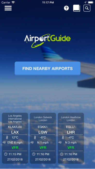
Unlike other apps, Airport Guide is designed for pilots to aid in flight planning by answering questions such as what airport has a paved runway at least 4000 feet long above 5000 feet MSL in the state of California between 100 and 150 miles of Los Angeles. With Airport Guide, you get the full AirportGuide.com database to search on the go with 50,000+ landing facilities. Most Airport Guide for Pilots features can be used offline so you can research the airport, perform E6B calculations with one of the many aviation calculators, and reference the aviation Book library. If you happen to be online, you can also use the handy Find Nearby Airports button on the home page to immediately show the nearest fields to your location using your GPS coordinates. As with all search results, this list can be filtered to show only public airports in case you are in the air and need to know your options to land quickly.
After performing a search, you can save any airports as a Favorite and it will show on the home page when you open the app to immediately tell you the latest weather (VFR, MVFR, IFR, LIFR). Select the airport and get key airport information such as the latest METAR, location, comm frequencies, runway info, FBOs, and fuel. You can even rate and review the airport to help your fellow pilots. If you have ever flown into an airport and needed a car or hotel, look no further than the booking links at the bottom of each airport screen to get you set up with lodging and transportation in no time. If you are looking for things to do in the area, just click on the Things To Do button to book attractions with an e-ticket sent to your phone.
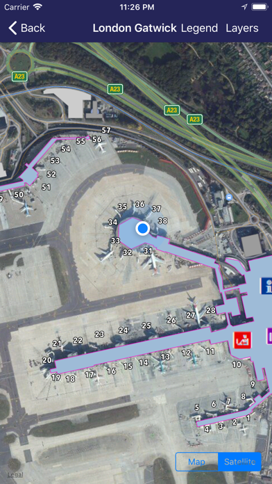
375+ Airport Terminal Maps are here! View your location in the terminal and see where gates and services are located.
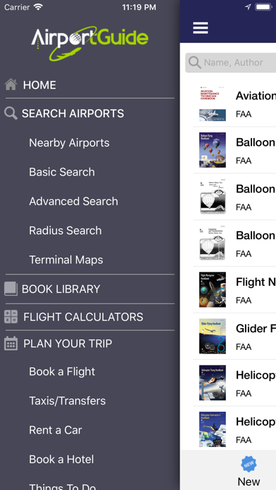
The three main areas in the Airport Guide app:
AIRPORT SEARCH
Get the full AirportGuide.com landing facility database including all public, private, and military airports, heliports, seaplane bases, STOLports, gliderports, balloonports, and ultralight fields throughout the world. Search the database using any of the following fields:
• Airport IDs - IATA ID, ICAO ID, Local ID (FAA, TC, etc.)
• Facility Use - public, private, military
• Facility Type - airport, balloonport, gliderport, heliport, seaplane base, ultralight
• Airport Name
• City
• State
• Country
• Minimum & Maximum Elevation
• Latitude and Longitude coordinates
• Runway length
• Paved runways
• Instrument approaches
• Minimum & Maximum distance from your location or airport of your choice
BOOK LIBRARY
Get the comprehensive library of FAA handbooks and Practical Test Standards through our Book Store. View samples and download books with an in-app purchase.
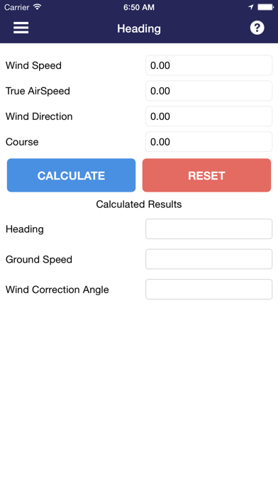
FLIGHT CALCULATORS
Use our E6B calculators to help you perform your flight planning tasks. If there is a calculator you would like to see included please let us know. The main categories are:
• Wind & Ground Speed
• Time/Distance Speed
• Temperature Calculations
• Density and Pressure
• Turning Performance
• Airport Distance and Heading calculator between any two airports
Data Disclosure
---------------------
The airport database is the same one used on AirportGuide.com and is constantly being updated. However, new database releases are usually made approximately every 4 weeks and will show as a database update within the app settings. The airport database has been evolving for more than 25 years with data from the FAA, DAFIF, and many international AIP sources. While we strive for perfection, the airport data changes quite frequently, and is not guaranteed to be 100% accurate at any given time. Airport Guide is a very useful resource for pilots but please consult official data sources when planning your flight.
Feedback and Support
-------------------------------
We encourage feedback from data issues to user interface issues to new suggestions. With your help, this app will only get better with time. Thanks!
Hide
Show More...
After performing a search, you can save any airports as a Favorite and it will show on the home page when you open the app to immediately tell you the latest weather (VFR, MVFR, IFR, LIFR). Select the airport and get key airport information such as the latest METAR, location, comm frequencies, runway info, FBOs, and fuel. You can even rate and review the airport to help your fellow pilots. If you have ever flown into an airport and needed a car or hotel, look no further than the booking links at the bottom of each airport screen to get you set up with lodging and transportation in no time. If you are looking for things to do in the area, just click on the Things To Do button to book attractions with an e-ticket sent to your phone.
375+ Airport Terminal Maps are here! View your location in the terminal and see where gates and services are located.
The three main areas in the Airport Guide app:
AIRPORT SEARCH
Get the full AirportGuide.com landing facility database including all public, private, and military airports, heliports, seaplane bases, STOLports, gliderports, balloonports, and ultralight fields throughout the world. Search the database using any of the following fields:
• Airport IDs - IATA ID, ICAO ID, Local ID (FAA, TC, etc.)
• Facility Use - public, private, military
• Facility Type - airport, balloonport, gliderport, heliport, seaplane base, ultralight
• Airport Name
• City
• State
• Country
• Minimum & Maximum Elevation
• Latitude and Longitude coordinates
• Runway length
• Paved runways
• Instrument approaches
• Minimum & Maximum distance from your location or airport of your choice
BOOK LIBRARY
Get the comprehensive library of FAA handbooks and Practical Test Standards through our Book Store. View samples and download books with an in-app purchase.
FLIGHT CALCULATORS
Use our E6B calculators to help you perform your flight planning tasks. If there is a calculator you would like to see included please let us know. The main categories are:
• Wind & Ground Speed
• Time/Distance Speed
• Temperature Calculations
• Density and Pressure
• Turning Performance
• Airport Distance and Heading calculator between any two airports
Data Disclosure
---------------------
The airport database is the same one used on AirportGuide.com and is constantly being updated. However, new database releases are usually made approximately every 4 weeks and will show as a database update within the app settings. The airport database has been evolving for more than 25 years with data from the FAA, DAFIF, and many international AIP sources. While we strive for perfection, the airport data changes quite frequently, and is not guaranteed to be 100% accurate at any given time. Airport Guide is a very useful resource for pilots but please consult official data sources when planning your flight.
Feedback and Support
-------------------------------
We encourage feedback from data issues to user interface issues to new suggestions. With your help, this app will only get better with time. Thanks!
In-Apps
- Unlock terminal maps
- 16.00 Rp
- Tips on Mountain Flying
- 16.00 Rp
- Risk Management Handbook
- 16.00 Rp
- PTS - Aircraft Dispatcher
- 16.00 Rp
- Rotorcraft Flying Handbook (Gyroplane ONLY)
- 16.00 Rp
- PTS - Sport Pilot - Airship, Balloon, and Flight Instructor
- 16.00 Rp
- PTS - Sport Pilot - Weight Shift Control, Powered Parachute
- 16.00 Rp
- PTS - Sport Pilot - Airplane, Gyroplane, Glider, and Flight Instructor
- 16.00 Rp
- Seaplane, Skiplane, and Float/Ski Equipped Helicopter Operations Handbook
- 16.00 Rp
Screenshots


Airport Guide FAQ
-
Is Airport Guide free?
Yes, Airport Guide is free to download, however it contains in-app purchases or subscription offerings.
-
Is Airport Guide legit?
Not enough reviews to make a reliable assessment. The app needs more user feedback.
Thanks for the vote -
How much does Airport Guide cost?
Airport Guide has several in-app purchases/subscriptions, the average in-app price is 16.00 Rp.
-
What is Airport Guide revenue?
To get estimated revenue of Airport Guide app and other AppStore insights you can sign up to AppTail Mobile Analytics Platform.

User Rating
App is not rated in Indonesia yet.
Ratings History
Airport Guide Reviews
No Reviews in Indonesia
App doesn't have any reviews in Indonesia yet.
Store Rankings
Ranking History
App Ranking History not available yet
Category Rankings
App is not ranked yet
Airport Guide Installs
Last 30 days
Airport Guide Revenue
Last 30 daysAirport Guide Revenue and Downloads
Gain valuable insights into Airport Guide performance with our analytics.
Sign up now to access downloads, revenue, and more.
Sign up now to access downloads, revenue, and more.
App Info
- Category
- Travel
- Publisher
- Forte Web Properties
- Languages
- English
- Recent release
- 1.4.4 (4 years ago )
- Released on
- Jun 16, 2016 (8 years ago )
- Also available in
- United States , Ukraine , Nepal , Italy , Australia , Hong Kong SAR China , Peru , Poland , New Zealand , Norway , Netherlands , Nigeria , Malaysia , Mexico , Lebanon , Kazakhstan , Kuwait , South Korea , Philippines , Pakistan , India , Portugal , Romania , Russia , Saudi Arabia , Sweden , Singapore , Slovenia , Thailand , Türkiye , Taiwan , Vietnam , South Africa , Dominican Republic , Argentina , Austria , Azerbaijan , Belgium , Brazil , Belarus , Canada , Switzerland , Chile , China , Colombia , Czechia , Germany , Denmark , Japan , Algeria , Ecuador , Estonia , Egypt , Spain , Finland , France , United Kingdom , Greece , Hungary , Indonesia , Ireland , Israel , United Arab Emirates
- Last Updated
- 1 week ago
This page includes copyrighted content from third parties, shared solely for commentary and research in accordance with fair use under applicable copyright laws. All trademarks, including product, service, and company names or logos, remain the property of their respective owners. Their use here falls under nominative fair use as outlined by trademark laws and does not suggest any affiliation with or endorsement by the trademark holders.