
Share Tracks
Sports, travel and photography
#1 Keyword Rankings
Today
Top 10 Rankings
Today
Top 30 Rankings
Today
Top 100 Rankings
Today
Description
"Share Track" can record and share information such as travel routes, vehicle driving routes, and motion tracks according to user needs:
It is compact and compact, easy to operate.
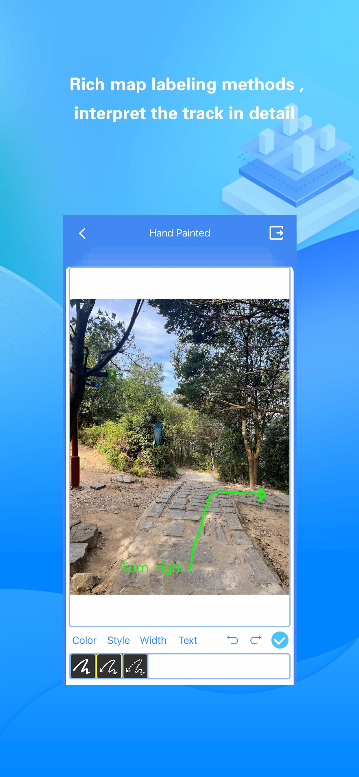
“Share Track” has rich map annotation methods,it can use voice, text, video, photos and hand painted photos to mark any place on the map.
The imported/exported track data format is rich and compatible with various map software.
Adaptive to various track types (cycling, self-driving, hiking, etc.) and switching, eliminating the trouble of determining the type of motion in advance.
Automatically correct the track points very rigorously to ensure the accuracy of the track.
"Share Track" can closely combine videos, photos and track data to provide users with different sports and travel experiences:
You can include videos, photos and voices in the mobile phone album into the track data, and share with other friends with one click.
Videos/photos taken by the user during track recording can be loaded with one click. Depending on the geographic location of the Videos/photos, the videos/photos will automatically be displayed on the map with the track.
Photos/videos in mobile phone albums and recorded voices can be marked on the map to form rich annotations for tracks.
If you have “Share Track":
You can use Google Earth software to browse the travel routes, vehicle driving routes and motion tracks recorded by "Share Track" in the 3D scene, and you can also send track data to your friends' mobile phones through instant messaging tools such as FaceBook and Twitter.
You can include videos, photos and voices in the mobile phone album into the track data, and share with other friends with one click. Your friends can enjoy your shared videos and photos on the map simply by importing the track files you shared into "Share Track".
You can always enjoy the videos and photos of each trip on the map and relive the good memories.
You can view your altitude, speed and direction in real time while running or traveling outdoors.
You can make informative road books (including videos, photos, voices, tracks, etc.) to offer to your friends.
You can get real-time guidance to your destination through the track navigation function.
It is a tool related to track,track recording,footprint,cycling,outdoor,hiking,running,walking,driving,map,travel,navigation,mountaineering and other activities.
Hide..
Show more..
It is compact and compact, easy to operate.
“Share Track” has rich map annotation methods,it can use voice, text, video, photos and hand painted photos to mark any place on the map.
The imported/exported track data format is rich and compatible with various map software.
Adaptive to various track types (cycling, self-driving, hiking, etc.) and switching, eliminating the trouble of determining the type of motion in advance.
Automatically correct the track points very rigorously to ensure the accuracy of the track.
"Share Track" can closely combine videos, photos and track data to provide users with different sports and travel experiences:
You can include videos, photos and voices in the mobile phone album into the track data, and share with other friends with one click.
Videos/photos taken by the user during track recording can be loaded with one click. Depending on the geographic location of the Videos/photos, the videos/photos will automatically be displayed on the map with the track.
Photos/videos in mobile phone albums and recorded voices can be marked on the map to form rich annotations for tracks.
If you have “Share Track":
You can use Google Earth software to browse the travel routes, vehicle driving routes and motion tracks recorded by "Share Track" in the 3D scene, and you can also send track data to your friends' mobile phones through instant messaging tools such as FaceBook and Twitter.
You can include videos, photos and voices in the mobile phone album into the track data, and share with other friends with one click. Your friends can enjoy your shared videos and photos on the map simply by importing the track files you shared into "Share Track".
You can always enjoy the videos and photos of each trip on the map and relive the good memories.
You can view your altitude, speed and direction in real time while running or traveling outdoors.
You can make informative road books (including videos, photos, voices, tracks, etc.) to offer to your friends.
You can get real-time guidance to your destination through the track navigation function.
It is a tool related to track,track recording,footprint,cycling,outdoor,hiking,running,walking,driving,map,travel,navigation,mountaineering and other activities.
Screenshots


 User Rating
0 out of 5
0 ratings in Kuwait
Ratings History
Reviews
App doesn't have any reviews yet
Store Rankings
Ranking History
App Ranking History not available yet
Category Rankings
|
Chart
|
Category
|
Rank
|
|---|---|---|
|
Top Paid
|

|
122
|
|
Top Paid
|

|
153
|
|
Top Paid
|

|
156
|
|
Top Paid
|

|
203
|
|
Top Paid
|

|
210
|
Keywords
Revenue and Downloads
Gain valuable insights into 分享轨迹 performance with our analytics. Sign up now
to
access downloads, revenue, and more.
App Info
- Category
- Travel
- Languages
- Russian, Indonesian, German, Japanese, French, Chinese, English, Portuguese, Spanish, Vietnamese, Arabic, Korean
- Recent version
- 6.30 (3 weeks ago )
- Released on
- Aug 29, 2013 (10 years ago )
- Also available in
- China, Portugal, South Korea, Kuwait, Kazakhstan, Lebanon, Mexico, Malaysia, Nigeria, Netherlands, Norway, New Zealand, Peru, Philippines, Pakistan, Poland, Japan, Romania, Russia, Saudi Arabia, Sweden, Singapore, Thailand, Turkey, Taiwan, Ukraine, United States, Vietnam, South Africa, Ecuador, Argentina, Austria, Australia, Belgium, Brazil, Belarus, Canada, Chile, Colombia, Czechia, Denmark, Dominican Republic, Algeria, United Arab Emirates, Egypt, Spain, Finland, France, Greece, Hong Kong, Hungary, Indonesia, Ireland, Israel, India, Italy
- Last updated
- 1 month ago