
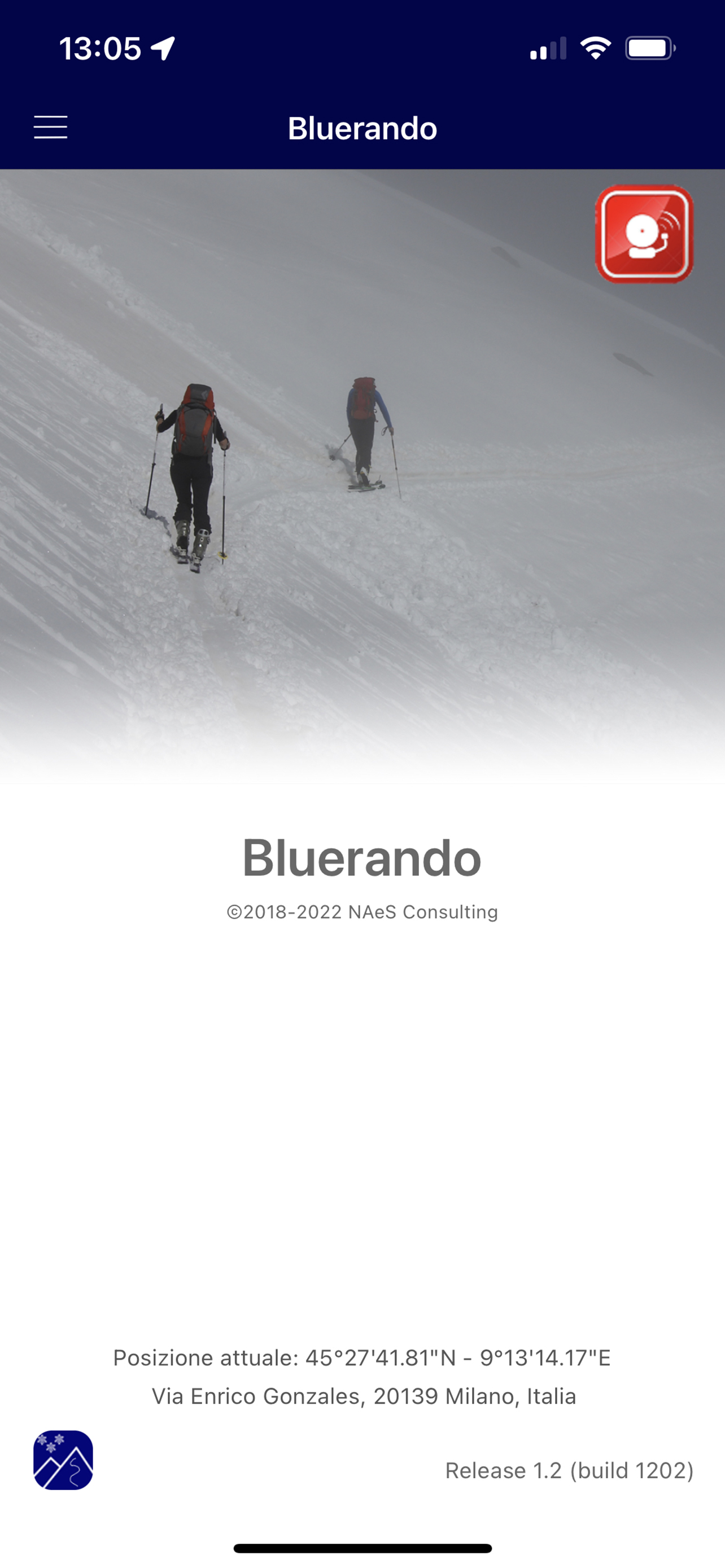
Bluerando
Published by:
Naes Consulting srl
Description
Bluerando è la app per chiunque ami andare in salita ... e in discesa. Scialpinisti, snowboarder, ciclisti, runner ed escursionisti. Pianifica i tuoi percorsi, controlla i tuoi successi e condividi i report con gli amici.
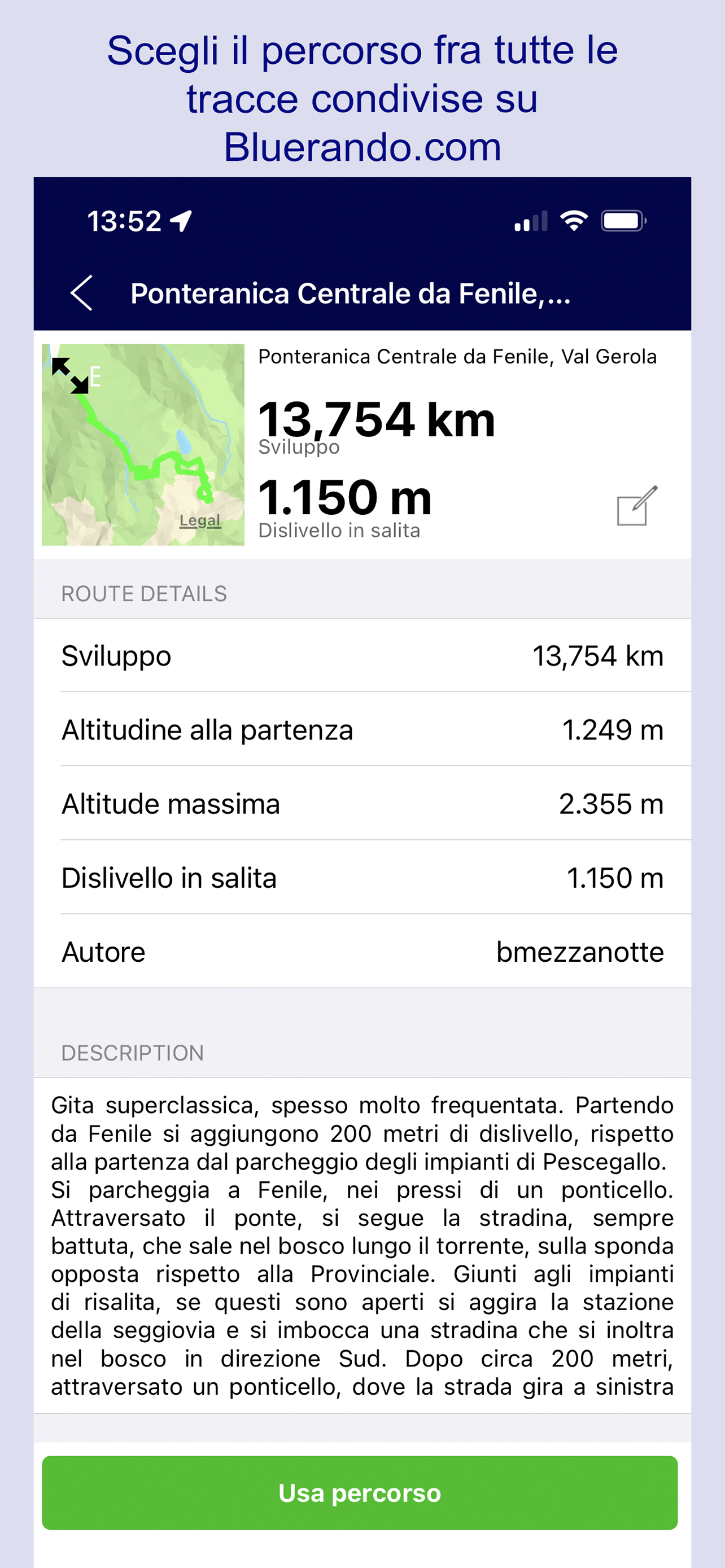
PIANIFICA IL PERCORSO MIGLIORE PER LA TUA ESCURSIONE
Traccia il tuo percorso scegliendo la mappa preferita fra le molte disponibili. Comprese le mappe dell'Istituto Federale Svizzero, le migliori al mondo, quelle di IGN France o USGS National Map. Puoi disegnare il tuo percorso sulle mappe del Portale Bluerando, oppure cercare fra quelli condivisi dagli altri utenti, direttamente sulla app.
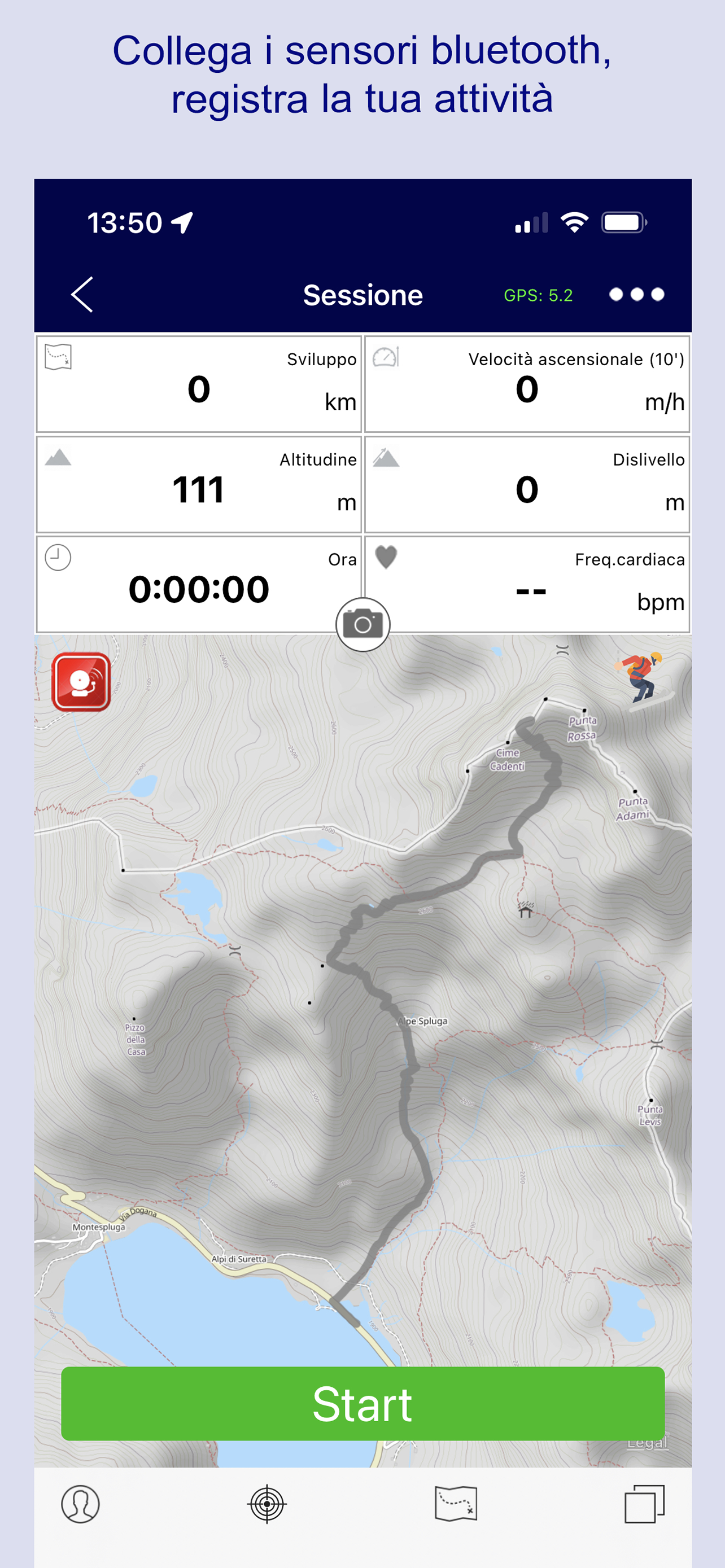
REGISTRA LA TUA ATTIVITA'
Durante l'escursione, controlla la tua traccia sulla mappa e verifica se corrisponde al percorso previsto. Controlla la posizione dei tuoi compagni di gita, direttamente sullo schermo del tuo telefono. In caso di bisogno, invia la tua posizione via email o sms. Collega Bluerando al cardiofrequenzimetro e tieni sotto controllo i tuoi battiti.
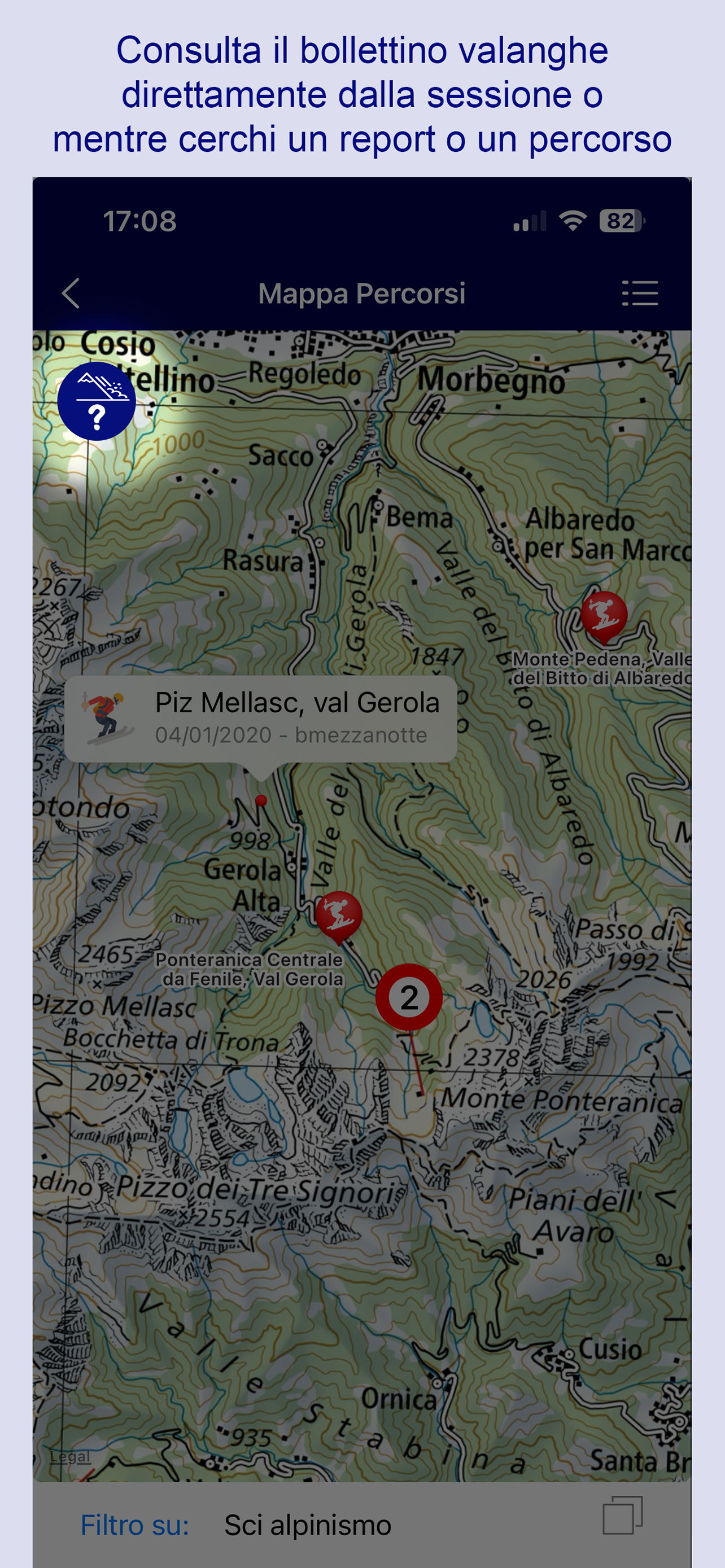
BOLLETTINI VALANGHE
Se la tua attività si svolge in ambiente innevato, valuta bene i rischi ambientali. Bluerando ti aiuta mostrandoti con un solo click tutti i bollettini valanghe disponibili per la zona in cui ti stati muovendo. Al momento, abbiamo a disposizione i bollettini AINEVA, Meteomont ed SLF/WhiteRisk. Copriamo dunque tutto il territorio italiano e svizzero, e le aree limitrofe. Lavoriamo senza sosta per estendere la copertura ad altre zone.
APPLE WATCH
Con un colpo d'occhio al quadrante del tuo Apple Watch controlla il tempo, il battito, la velocità, il dislivello...
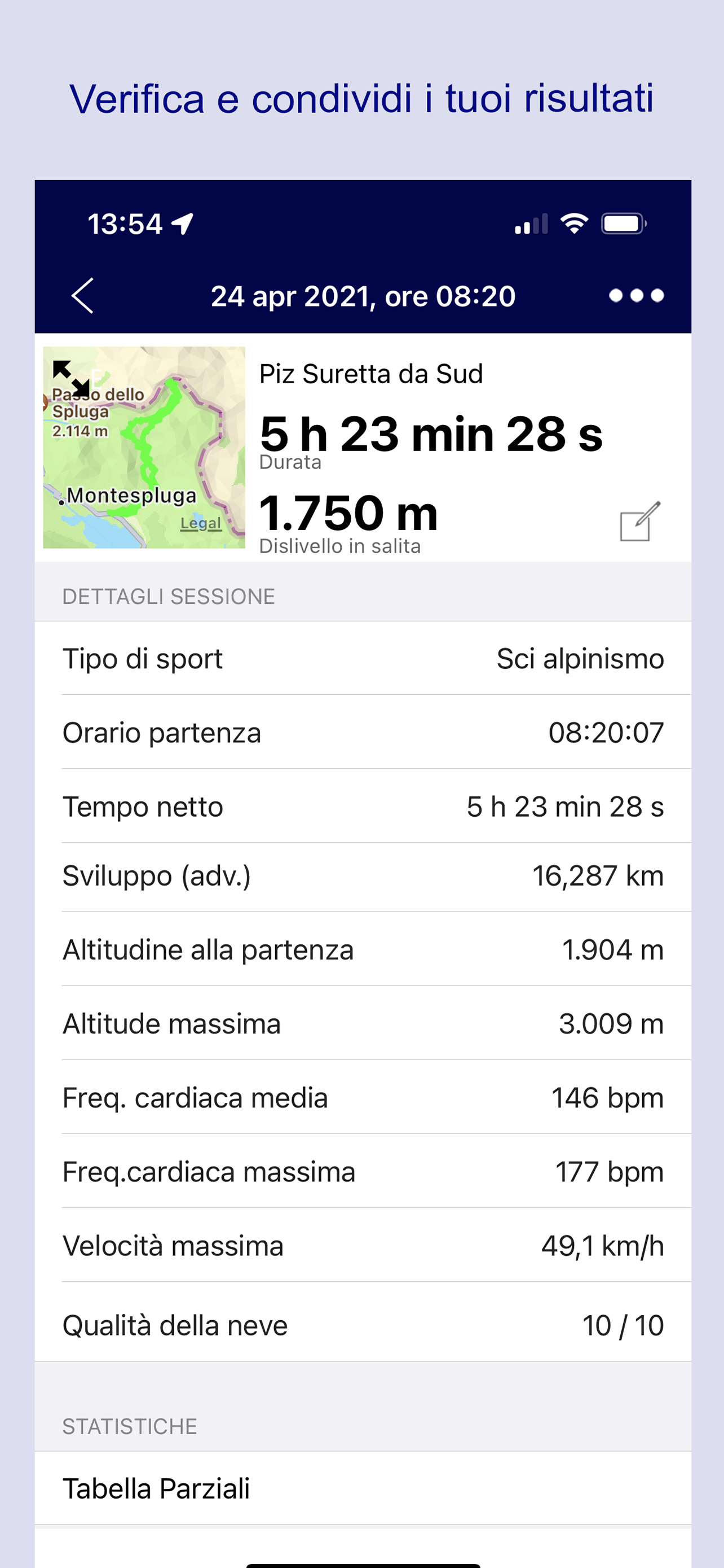
CONDIVIDI LA TUA ESPERIENZA
A fine gita, racconta la tua esperienza. Scrivi un breve report raccontando le tue sensazioni e le condizioni incontrate. Potranno tornare utili a chi sta progettando un'escursione in zona.
Salva e condividi la tua traccia come percorso, in modo che possa essere trovata ed utilizzata da altri, o da te stesso, quando pianificheranno una nuova attività.
CONTRIBUISCI ALLA SICUREZZA DI TUTTI
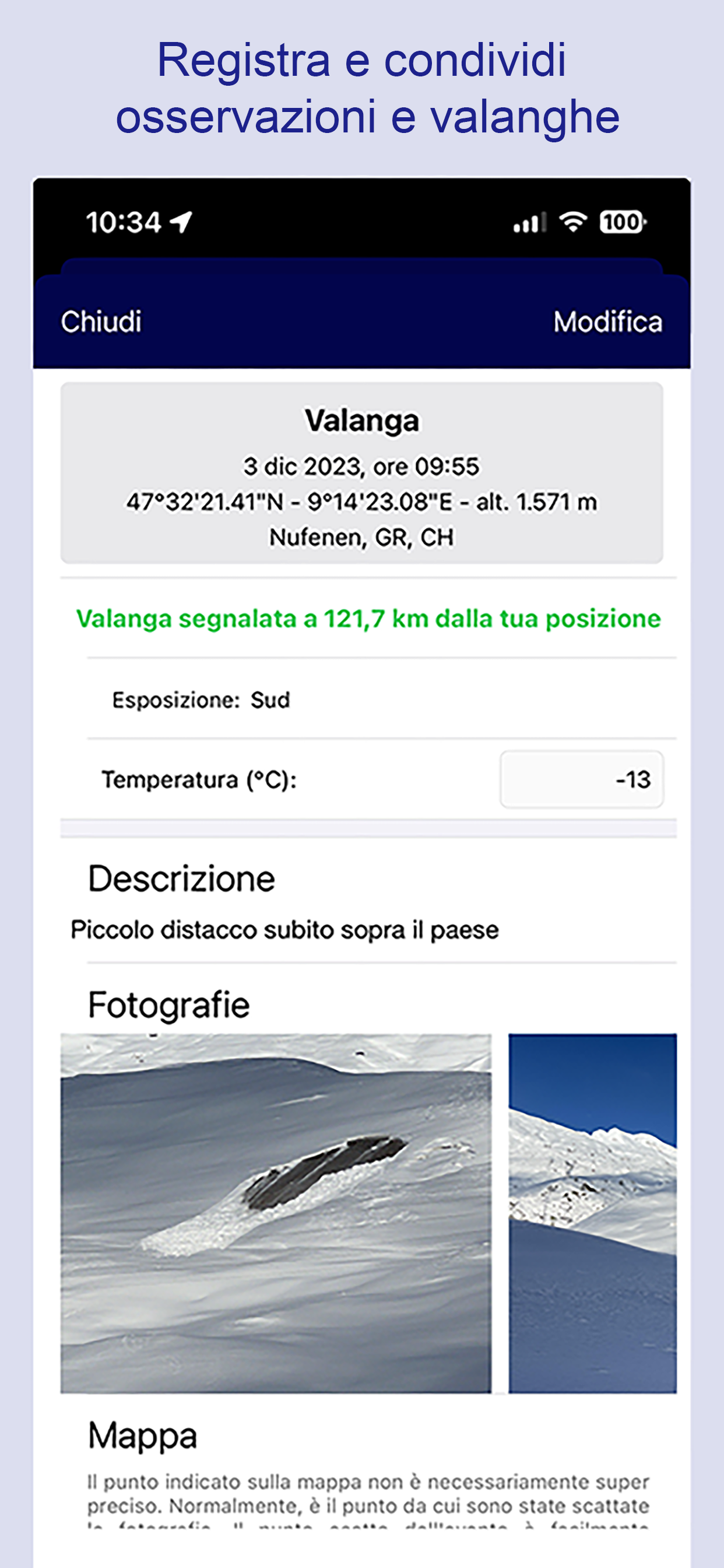
Utilizza la nuova funzione Osserva & Segnala, scatta qualche foto, descrivi l'evento o la situazione cui hai assistito. In particolare, fotografa e condividi segnali di distacchi e valanghe. Il telefono si occuperà di localizzare la segnalazione e registrare altri elementi importanti, come la temperatura dell'aria. Tutte queste informazioni, naturalmente in forma rigorosamente anonima, andranno a costituire un database condiviso con gli enti che ne hanno fatto e ne faranno richiesta. In particolare, con coloro che elaborano quotidianamente i bollettini valanghe a vantaggio di tutti noi. Sono per loro informazioni preziose, per aiutarli a verificare le previsioni e migliorare costantemente i modelli utilizzati.
Bluerando si è posta l'obiettivo di contribuire attivamente a diffondere una cultura di frequentazione consapevole della montagna, specialmente nella sua splendida veste invernale. Per questo motivo abbiamo introdotto le nuove funzionalità: la consultazione dei bollettini valanghe direttamente in App e, soprattutto, la funzione "Osserva e Segnala". Vai su https://www.bluerando.com per maggiori dettagli.
Hide
Show More...
PIANIFICA IL PERCORSO MIGLIORE PER LA TUA ESCURSIONE
Traccia il tuo percorso scegliendo la mappa preferita fra le molte disponibili. Comprese le mappe dell'Istituto Federale Svizzero, le migliori al mondo, quelle di IGN France o USGS National Map. Puoi disegnare il tuo percorso sulle mappe del Portale Bluerando, oppure cercare fra quelli condivisi dagli altri utenti, direttamente sulla app.
REGISTRA LA TUA ATTIVITA'
Durante l'escursione, controlla la tua traccia sulla mappa e verifica se corrisponde al percorso previsto. Controlla la posizione dei tuoi compagni di gita, direttamente sullo schermo del tuo telefono. In caso di bisogno, invia la tua posizione via email o sms. Collega Bluerando al cardiofrequenzimetro e tieni sotto controllo i tuoi battiti.
BOLLETTINI VALANGHE
Se la tua attività si svolge in ambiente innevato, valuta bene i rischi ambientali. Bluerando ti aiuta mostrandoti con un solo click tutti i bollettini valanghe disponibili per la zona in cui ti stati muovendo. Al momento, abbiamo a disposizione i bollettini AINEVA, Meteomont ed SLF/WhiteRisk. Copriamo dunque tutto il territorio italiano e svizzero, e le aree limitrofe. Lavoriamo senza sosta per estendere la copertura ad altre zone.
APPLE WATCH
Con un colpo d'occhio al quadrante del tuo Apple Watch controlla il tempo, il battito, la velocità, il dislivello...
CONDIVIDI LA TUA ESPERIENZA
A fine gita, racconta la tua esperienza. Scrivi un breve report raccontando le tue sensazioni e le condizioni incontrate. Potranno tornare utili a chi sta progettando un'escursione in zona.
Salva e condividi la tua traccia come percorso, in modo che possa essere trovata ed utilizzata da altri, o da te stesso, quando pianificheranno una nuova attività.
CONTRIBUISCI ALLA SICUREZZA DI TUTTI
Utilizza la nuova funzione Osserva & Segnala, scatta qualche foto, descrivi l'evento o la situazione cui hai assistito. In particolare, fotografa e condividi segnali di distacchi e valanghe. Il telefono si occuperà di localizzare la segnalazione e registrare altri elementi importanti, come la temperatura dell'aria. Tutte queste informazioni, naturalmente in forma rigorosamente anonima, andranno a costituire un database condiviso con gli enti che ne hanno fatto e ne faranno richiesta. In particolare, con coloro che elaborano quotidianamente i bollettini valanghe a vantaggio di tutti noi. Sono per loro informazioni preziose, per aiutarli a verificare le previsioni e migliorare costantemente i modelli utilizzati.
Bluerando si è posta l'obiettivo di contribuire attivamente a diffondere una cultura di frequentazione consapevole della montagna, specialmente nella sua splendida veste invernale. Per questo motivo abbiamo introdotto le nuove funzionalità: la consultazione dei bollettini valanghe direttamente in App e, soprattutto, la funzione "Osserva e Segnala". Vai su https://www.bluerando.com per maggiori dettagli.
Screenshots

Bluerando FAQ
-
Is Bluerando free?
Yes, Bluerando is completely free and it doesn't have any in-app purchases or subscriptions.
-
Is Bluerando legit?
Not enough reviews to make a reliable assessment. The app needs more user feedback.
Thanks for the vote -
How much does Bluerando cost?
Bluerando is free.
-
What is Bluerando revenue?
To get estimated revenue of Bluerando app and other AppStore insights you can sign up to AppTail Mobile Analytics Platform.

User Rating
App is not rated in Türkiye yet.
Ratings History
Bluerando Reviews
Store Rankings
Ranking History
App Ranking History not available yet
Category Rankings
App is not ranked yet
Bluerando Installs
Last 30 days
Bluerando Revenue
Last 30 daysBluerando Revenue and Downloads
Gain valuable insights into Bluerando performance with our analytics.
Sign up now to access downloads, revenue, and more.
Sign up now to access downloads, revenue, and more.
App Info
- Category
- Sports
- Publisher
- Naes Consulting srl
- Languages
- Italian, French, English
- Recent release
- 1.6.6 (8 months ago )
- Released on
- Jan 2, 2023 (2 years ago )
- Also available in
- Italy, Ireland, South Africa, United States, Türkiye, Romania, Norway, Netherlands, Kuwait, Japan, Austria, United Kingdom, France, Algeria, Germany, Switzerland, Canada, Belgium, Azerbaijan
- Last Updated
- 3 weeks ago
This page includes copyrighted content from third parties, shared solely for commentary and research in accordance with fair use under applicable copyright laws. All trademarks, including product, service, and company names or logos, remain the property of their respective owners. Their use here falls under nominative fair use as outlined by trademark laws and does not suggest any affiliation with or endorsement by the trademark holders.