
Bristol Maps
BristolMap
#1 Keyword Rankings
Today
Top 10 Rankings
Today
Top 30 Rankings
Today
Top 100 Rankings
Today
Description
Bristol Maps is designed specifically for commercial fishermen to navigate using the latest satellite imagery. Currently serving Bristol Bay and Copper River watersheds. Say goodbye to outdated maps and inaccurate information - our app utilizes the latest, detailed images for increased efficiency, safer fishing trips, and a higher return on investment.
As a fisherman like you, I've always used NOAA charts for the Bay. Given how fast the environment changes, these are at best, unreliable and at worst, dangerous.
For this I developed Bristol Maps, an app that leverages curated satellite images taken during low tide, displaying the current bar locations, and allows for multiple images to be layered. For areas with multiple images at varying tides, this app allows you to see where there will, or won’t be navigable water. Additionally, these images can be overlayed onto the traditional NOAA charts.
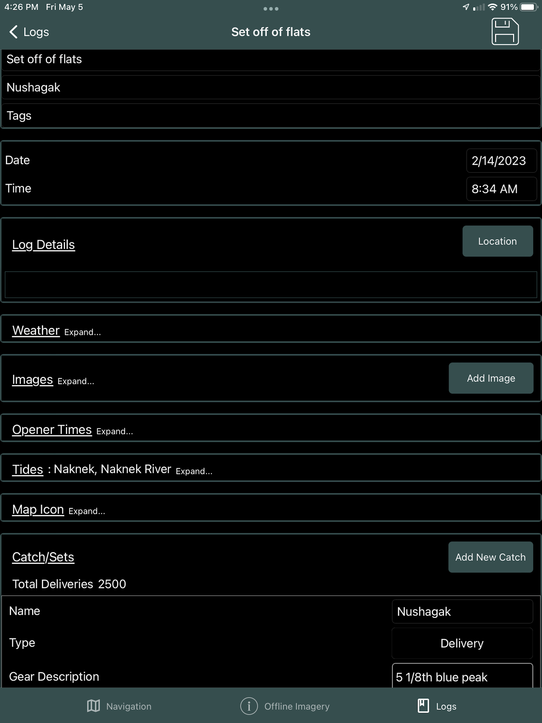
Beyond the core mapping functionality, tide and weather forecasts are also available. Weather can be pinpointed to a location as well as the nearest NOAA zone weather forecast. This information can be combined with the mapping functionality to create digital logs. Location, catch, weather, and tide data can be integrated into a log event. Logs can be overlaid onto the navigation page and analyzed to view catch data by area, gear type (4.75" vs 5"), and weather.
Feature list:
* Private groups for sharing location, custom routes and waypoints.
* Private group chat.
* Satellite overlays available for: Naknek/Kvichak, Egegik, Ugashik, Nushagak, and Copper River. Updated seasonally.
* NOAA overlays available offline for all of Alaska.
* Location grid layouts, organized by color and number, which can replace traditional paper maps or code tables shared by Groups. ie: "I'm over by green 22." A search tool is included to quickly find locations.
* NOAA tide charts available offline for Bristol Bay tide stations. Other locations downloaded as they are used.
* Pinpoint weather forecasts available as well as NOAA zone weather forecasts.
* Boundary lines (with “alarm” functionality), for all major districts are preprogrammed along with the ability to create new boundaries.
* Create Waypoints and Routes. These can also be exported/imported to/from other users to share data.
* Online maps can be streamed with NOAA charts, custom satellite views, a high-res AK Government view, and street view.
* Log entries for recording opener times, district, pictures, sets/deliveries, and automatic tide/weather history.
Bristol Maps has been designed with an intuitive, user friendly interface to solve a common fisherman problem.
Bristol Maps Pricing $150/Year
A two-week free trial is included for testing and includes free cancellation. Subscription includes updates, bug fixes and seasonal imagery additions.
Hide..
Show more..
As a fisherman like you, I've always used NOAA charts for the Bay. Given how fast the environment changes, these are at best, unreliable and at worst, dangerous.
For this I developed Bristol Maps, an app that leverages curated satellite images taken during low tide, displaying the current bar locations, and allows for multiple images to be layered. For areas with multiple images at varying tides, this app allows you to see where there will, or won’t be navigable water. Additionally, these images can be overlayed onto the traditional NOAA charts.
Beyond the core mapping functionality, tide and weather forecasts are also available. Weather can be pinpointed to a location as well as the nearest NOAA zone weather forecast. This information can be combined with the mapping functionality to create digital logs. Location, catch, weather, and tide data can be integrated into a log event. Logs can be overlaid onto the navigation page and analyzed to view catch data by area, gear type (4.75" vs 5"), and weather.
Feature list:
* Private groups for sharing location, custom routes and waypoints.
* Private group chat.
* Satellite overlays available for: Naknek/Kvichak, Egegik, Ugashik, Nushagak, and Copper River. Updated seasonally.
* NOAA overlays available offline for all of Alaska.
* Location grid layouts, organized by color and number, which can replace traditional paper maps or code tables shared by Groups. ie: "I'm over by green 22." A search tool is included to quickly find locations.
* NOAA tide charts available offline for Bristol Bay tide stations. Other locations downloaded as they are used.
* Pinpoint weather forecasts available as well as NOAA zone weather forecasts.
* Boundary lines (with “alarm” functionality), for all major districts are preprogrammed along with the ability to create new boundaries.
* Create Waypoints and Routes. These can also be exported/imported to/from other users to share data.
* Online maps can be streamed with NOAA charts, custom satellite views, a high-res AK Government view, and street view.
* Log entries for recording opener times, district, pictures, sets/deliveries, and automatic tide/weather history.
Bristol Maps has been designed with an intuitive, user friendly interface to solve a common fisherman problem.
Bristol Maps Pricing $150/Year
A two-week free trial is included for testing and includes free cancellation. Subscription includes updates, bug fixes and seasonal imagery additions.
In-Apps
- Bristol Maps
- $200.00
Screenshots


 User Rating
0 out of 5
0 ratings in Canada
Ratings History
Reviews
App doesn't have any reviews yet
Store Rankings
Ranking History
App Ranking History not available yet
Category Rankings
|
Chart
|
Category
|
Rank
|
|---|---|---|
|
Top Grossing
|

|
41
|
Keywords
Users may also like
| Name | Reviews | Recent release | |
|---|---|---|---|

SEAiq USA
|
0
|
2 weeks ago | |

Flytomap All in One HD Charts
Charts & Maps GPS Navigator
|
1
|
2 weeks ago | |

Rule Master
Rules of the Road Toolbox
|
1
|
6 months ago | |

NZ Topo50 South Island
Complete offline 1:50k map
|
1
|
5 months ago | |

Tide Graph Pro
Most trusted US Tide App
|
0
|
2 months ago | |

FindShip Pro - Track vessels
AIS Ship Tracking
|
6
|
4 months ago | |

Timberline Mountain
|
0
|
2 weeks ago | |

Buoy Locator
Fishing buoy map with GPS data
|
0
|
1 year ago | |

Coastal Explorer
Cruise planning and navigation
|
1
|
3 months ago | |

Speedometer Gratis
Vitezometru
|
0
|
5 months ago |
Show More
Revenue and Downloads
Gain valuable insights into Bristol Maps performance with our analytics. Sign up now
to
access downloads, revenue, and more.
App Info
- Category
- Navigation
- Publisher
- Chris Hager
- Languages
- Recent version
- 2.25 (1 week ago )
- Released on
- May 7, 2023 (1 year ago )
- Also available in
- United States, Canada
- Last updated
- 4 weeks ago