
Description
This Augmented Reality app lets you find Buildings, Restaurants, and Bus Stops on most University Campus or Theme Park in the U.S. Use the camera on your mobile phone or iPad to find your way around campus. Use the search bar to narrow down your search and the amount of popups on the screen. Buildings will only appear once you are on the campus itself.
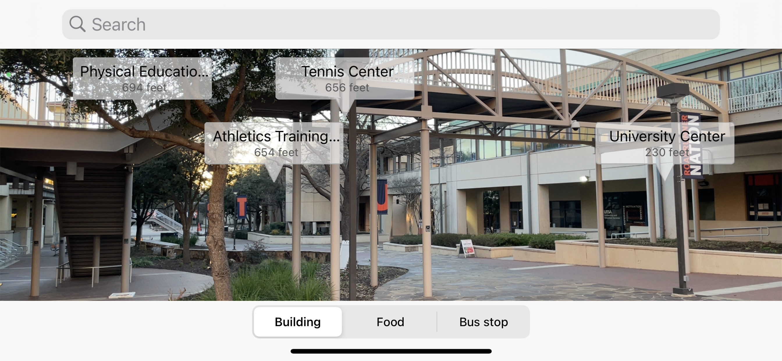
Features - Building names and distance from your location will popup on your screen. Click on the popup to see an image of the building if any. The user can type in any building name in the Search bar they want to find. A blue directional arrow will appear at the bottom and will direct you which way to turn your phone. Next you turn until the directional arrow is pointing straight up. You will then see the building you are looking for on your screen with how far it is located from where you are standing.
Hide
Show More...
Features - Building names and distance from your location will popup on your screen. Click on the popup to see an image of the building if any. The user can type in any building name in the Search bar they want to find. A blue directional arrow will appear at the bottom and will direct you which way to turn your phone. Next you turn until the directional arrow is pointing straight up. You will then see the building you are looking for on your screen with how far it is located from where you are standing.
Screenshots


Campus Footprints FAQ
-
Is Campus Footprints free?
Yes, Campus Footprints is completely free and it doesn't have any in-app purchases or subscriptions.
-
Is Campus Footprints legit?
Not enough reviews to make a reliable assessment. The app needs more user feedback.
Thanks for the vote -
How much does Campus Footprints cost?
Campus Footprints is free.
-
What is Campus Footprints revenue?
To get estimated revenue of Campus Footprints app and other AppStore insights you can sign up to AppTail Mobile Analytics Platform.

User Rating
App is not rated in Kuwait yet.
Ratings History
Campus Footprints Reviews
Store Rankings
Ranking History
App Ranking History not available yet
Category Rankings
App is not ranked yet
Campus Footprints Installs
Last 30 days
Campus Footprints Revenue
Last 30 daysCampus Footprints Revenue and Downloads
Gain valuable insights into Campus Footprints performance with our analytics.
Sign up now to access downloads, revenue, and more.
Sign up now to access downloads, revenue, and more.
App Info
- Category
- Navigation
- Publisher
- Campus Footprints
- Languages
- English
- Recent release
- 1.2 (2 years ago )
- Released on
- Aug 6, 2018 (6 years ago )
- Also available in
- United States, India, Portugal, South Korea, Kuwait, Kazakhstan, Lebanon, Mexico, Malaysia, Nigeria, Netherlands, Norway, New Zealand, Peru, Philippines, Pakistan, Poland, Italy, Romania, Russia, Saudi Arabia, Sweden, Singapore, Slovenia, Slovakia, Thailand, Türkiye, Taiwan, Ukraine, Vietnam, South Africa, Denmark, Argentina, Australia, Azerbaijan, Belgium, Brunei, Brazil, Belarus, Canada, Switzerland, Chile, China, Colombia, Czechia, Germany, Japan, Dominican Republic, Algeria, Ecuador, Egypt, Spain, Finland, France, United Kingdom, Greece, Hungary, Indonesia, Ireland, Israel, Armenia
- Last Updated
- 1 day ago
This page includes copyrighted content from third parties, shared solely for commentary and research in accordance with fair use under applicable copyright laws. All trademarks, including product, service, and company names or logos, remain the property of their respective owners. Their use here falls under nominative fair use as outlined by trademark laws and does not suggest any affiliation with or endorsement by the trademark holders.