Description
The Cartograph app views Mapsforge offline vector maps, offline raster maps, and online/WMS maps. It supports tracking, route search, overlays, hillshading, reliefs, track drawing, and has many other features.
Cartograph Maps 3 is available here: https://www.cartograph.eu/v3/
### Features ###
- User interface languages: Dutch, English, French, German, Italian, Russian, Spanish, Traditional Chinese.
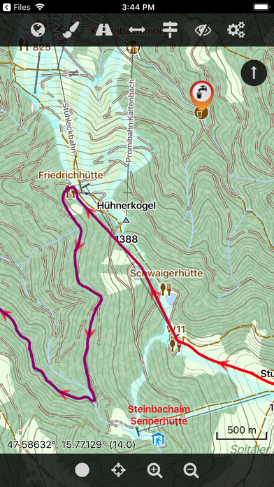
- View Mapsforge offline vector maps (including v5 format).
- Full support for Mapsforge styling/render themes (including hillshading) and layers.
- Offline raster maps: Locus SQLite maps, MBTiles, TwoWays/CompeGPS RMAP*, Oruxmaps SQLite*.
- Online map support (including WMS - Web Map Service maps), e.g. OpenStreetMap, OpenCycleMap, OpenSeaMap, WikiMedia hillshading, etc.
- Import online maps easily from files: "http://www.cartograph.eu/help_onlinemapimport".
- Offline hillshading (from HGT elevation data).
- Offline relief shading.
- Offline slope maps (experimental).
- Contour lines (Mapsforge maps).
- Worldwide, free offline maps.
- Support for Mapsforge multi-maps (multiple .map files stitched into a single map).
- Night/day mode.
- GPS Track recording.
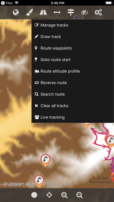
- Manual track drawing and editing.
- GPX import and export (basic KML/KMZ import support).
- Import of photos with EXIF tags as waypoints.
- Import of KMZ photo series.
- Import Google Maps POIs/Places using Google Takeout data export function.
- Upload tracks to Strava.com.
- Route altitude profile and elevation/slope visualization.
- Online route search.
- Live tracking and polling (using custom server, GPSies.com, or Cartograph server).
- Support for Mapsforge POIs, offline POI search, and dynamic POI loading.
- Scalable interface (e.g. to increase button sizes).
- Compass.
- Units: Celsius, Kelvin, Fahrenheit, metric, imperial, nautic.
- Decimal and degree coordinate modes.
- Supports Mapsforge multi-language maps and POIs.
- Map import: iOS 11 File Browser, Wifi upload, iTunes file sharing, internal download manager, and import using "Open in" from 3rd party apps like Safari, Chrome, DropBox, etc.
- Voice/sound alerts along routes and waypoints. *EXPERIMENTAL*
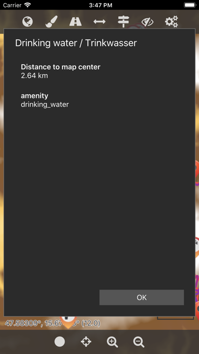
- WaterSupply.at drinking water sources.
- Customizable user interface color (dark, light, and colors) and size.
- 3D map snapshot view for an overview over the current map region.
* RMAP and Oruxmaps use various map projections and support is experimental. Please contact us if a map does not work so that we can add support for your projection.
Further information: http://www.cartograph.eu
Getting started: https://www.cartograph.eu/gettingstarted
Help&Tutorial: https://www.cartograph.eu/docs
Facebook: https://www.facebook.com/Cartograph.eu/
User manual: http://www.cartograph.eu/downloads/usermanual_en.pdf
YouTube how-to videos: https://www.youtube.com/watch?v=dn9EOg5h3yY&list=PLP8X6xYv-qCz46hplsfGLW1LNgywBZrTk
Please drop us a line if you have questions or feature requests: http://www.cartograph.eu/contact
### Maps ###
- Offline Map Downloader (https://www.tequnique.com/offlinemapdownloader)
- OpenAndroMaps.org: very good maps for outdoor activities.
Hide..
Show more..
Cartograph Maps 3 is available here: https://www.cartograph.eu/v3/
### Features ###
- User interface languages: Dutch, English, French, German, Italian, Russian, Spanish, Traditional Chinese.
- View Mapsforge offline vector maps (including v5 format).
- Full support for Mapsforge styling/render themes (including hillshading) and layers.
- Offline raster maps: Locus SQLite maps, MBTiles, TwoWays/CompeGPS RMAP*, Oruxmaps SQLite*.
- Online map support (including WMS - Web Map Service maps), e.g. OpenStreetMap, OpenCycleMap, OpenSeaMap, WikiMedia hillshading, etc.
- Import online maps easily from files: "http://www.cartograph.eu/help_onlinemapimport".
- Offline hillshading (from HGT elevation data).
- Offline relief shading.
- Offline slope maps (experimental).
- Contour lines (Mapsforge maps).
- Worldwide, free offline maps.
- Support for Mapsforge multi-maps (multiple .map files stitched into a single map).
- Night/day mode.
- GPS Track recording.
- Manual track drawing and editing.
- GPX import and export (basic KML/KMZ import support).
- Import of photos with EXIF tags as waypoints.
- Import of KMZ photo series.
- Import Google Maps POIs/Places using Google Takeout data export function.
- Upload tracks to Strava.com.
- Route altitude profile and elevation/slope visualization.
- Online route search.
- Live tracking and polling (using custom server, GPSies.com, or Cartograph server).
- Support for Mapsforge POIs, offline POI search, and dynamic POI loading.
- Scalable interface (e.g. to increase button sizes).
- Compass.
- Units: Celsius, Kelvin, Fahrenheit, metric, imperial, nautic.
- Decimal and degree coordinate modes.
- Supports Mapsforge multi-language maps and POIs.
- Map import: iOS 11 File Browser, Wifi upload, iTunes file sharing, internal download manager, and import using "Open in" from 3rd party apps like Safari, Chrome, DropBox, etc.
- Voice/sound alerts along routes and waypoints. *EXPERIMENTAL*
- WaterSupply.at drinking water sources.
- Customizable user interface color (dark, light, and colors) and size.
- 3D map snapshot view for an overview over the current map region.
* RMAP and Oruxmaps use various map projections and support is experimental. Please contact us if a map does not work so that we can add support for your projection.
Further information: http://www.cartograph.eu
Getting started: https://www.cartograph.eu/gettingstarted
Help&Tutorial: https://www.cartograph.eu/docs
Facebook: https://www.facebook.com/Cartograph.eu/
User manual: http://www.cartograph.eu/downloads/usermanual_en.pdf
YouTube how-to videos: https://www.youtube.com/watch?v=dn9EOg5h3yY&list=PLP8X6xYv-qCz46hplsfGLW1LNgywBZrTk
Please drop us a line if you have questions or feature requests: http://www.cartograph.eu/contact
### Maps ###
- Offline Map Downloader (https://www.tequnique.com/offlinemapdownloader)
- OpenAndroMaps.org: very good maps for outdoor activities.
Screenshots


User Rating
4.33 out of 5
3 ratings in Russia
5 star
1
4 star
2
3 star
0
2 star
0
1 star
0
Ratings History
Cartograph 2 Maps Installs
Last 30 days
Cartograph 2 Maps Revenue
Last 30 daysCartograph 2 Maps Reviews
Store Rankings
Ranking History
Category Rankings
|
Chart
|
Category
|
Rank
|
|---|---|---|
|
Top Paid
|

|
13
|
|
Top Paid
|

|
16
|
|
Top Paid
|

|
24
|
|
Top Paid
|

|
33
|
|
Top Paid
|

|
43
|
Keywords
Cartograph 2 Maps Competitors
| Name | Reviews | Recent release | |
|---|---|---|---|
Maps 3D PRO - Outdoor GPS
GPS for Bike, Hike & Ski
|
60
|
4 months ago | |

MapOut
Beautiful hiking & cycling map
|
3
|
9 months ago | |

Guru Maps Pro: Офлайн Карты
GPS Навигатор & Запись треков
|
261
|
1 month ago | |

Wanderfreund
|
0
|
2 years ago | |

Fun in Taichung
|
0
|
2 months ago | |

OUTMAP: hike, ski, outdoor
Your outdoor assistant
|
0
|
7 hours ago | |

QuoVadis X Mobile
Your journey. Advanced.
|
0
|
2 months ago | |

Taipei Historical Maps
|
0
|
1 year ago | |

OsmoTagger
OpenStreetMap editor
|
0
|
5 months ago | |

台灣燈塔
|
0
|
9 months ago |
Cartograph 2 Maps Revenue and Downloads
Gain valuable insights into Cartograph 2 Maps performance with our analytics.
Sign up now to access downloads, revenue, and more.
Sign up now to access downloads, revenue, and more.
App Info
- Category
- Navigation
- Publisher
- Harald Meyer
- Languages
- English
- Recent version
- 2.8.1 (2 years ago )
- Released on
- Feb 29, 2016 (8 years ago )
- Also available in
- Taiwan, Germany, United States, Hungary, United Kingdom, Russia, France, Italy, Czechia, Hong Kong, Finland, Poland, Indonesia, Ecuador, South Korea, Canada, Netherlands, Australia, Austria, Malaysia, Peru, New Zealand, Philippines, Norway, Nigeria, India, Pakistan, Portugal, Romania, Saudi Arabia, Sweden, Singapore, Thailand, Turkey, Ukraine, Vietnam, South Africa, Algeria, Argentina, Azerbaijan, Belgium, Brazil, Belarus, Switzerland, Chile, China, Colombia, Denmark, Dominican Republic, Mexico, Egypt, Spain, Greece, Ireland, Israel, United Arab Emirates, Japan, Kuwait, Kazakhstan, Lebanon
- Last updated
- 3 hours ago