
Colorado Trail Explorer
Colorado's Official Trail Map
#1 Keyword Rankings
Today
Top 10 Rankings
Today
Top 30 Rankings
Today
Top 100 Rankings
Today
Description
Discover and explore Colorado’s unique trail experiences with the Colorado Trail Explorer. Available for free, COTREX offers the most comprehensive trail map available for the state and is built atop data from over 230 trail managers.
View trails by allowed uses on the map, browse featured routes, download offline maps, record trips and notes in the field, complete challenges to earn badges, and share your experiences with the community. COTREX is your gateway into Colorado’s magnificent outdoors.
■ DISCOVER TRAILS & FEATURED ROUTES
– Browse or search to find trails and Feature Routes that match your activities or interests.
– Change activity type to dynamically filter trails on the map.
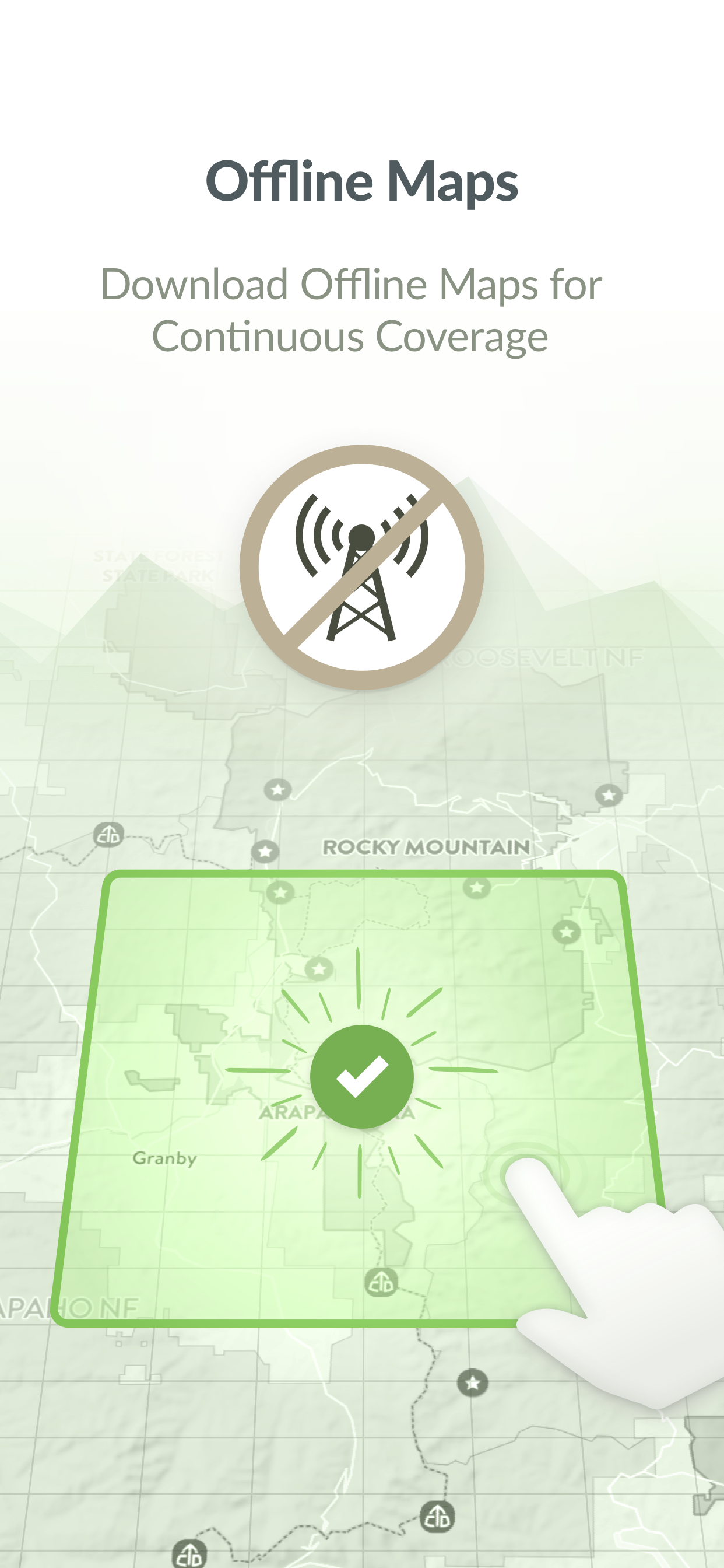
■ OFFLINE MAPS
– No cell coverage? No problem! Download maps ahead of time for a continuous experience that doesn’t depend on your network.
– COTREX offline maps are lightweight in size and easy to download.
■ RECORD TRIPS & FIELD NOTES
– Capture the details of your outdoor experiences by recording Trips.
– Go beyond simple photos by taking and classifying rich Field Notes along the way. Choose from 45,000+ classifications that include trail conditions, species, rocks and minerals, historic places, points of interest, and much more.
– Seamlessly sync activity recorded on your devices with the web.
■ COMPLETE CHALLENGES TO EARN BADGES
– By recording and classifying Field Notes, you can complete Challenges and earn Badges for your profile.
■ SHARE WITH THE COMMUNITY
– Inform and inspire the entire COTREX community by sharing your Trips and Field Notes publicly or submitting Trip Reports.
– View activity feeds for all users or just the ones you follow.
– By sharing your experiences, you also help to inform trail managers about current conditions on the ground.
■ ABOUT COTREX
The Colorado Trail Explorer endeavors to map every trail in the state of Colorado in support of the Colorado the Beautiful Initiative. COTREX connects people, trails, and technology by coordinating the efforts of federal, state, county, and local agencies to create a comprehensive repository of recreational trails for public use.
This project is led by Colorado Parks and Wildlife (CPW) and Department of Natural Resources, but is only made possible through partnerships with organizations at every level statewide. COTREX represents a seamless network of trails managed by over 230 land managers.
■ DISCLAIMERS
[Battery Life] We do everything we can to make the app low power when recording, but GPS is notorious for reducing battery life
Terms: https://trails.colorado.gov/terms
Privacy Policy: https://trails.colorado.gov/privacy
Hide..
Show more..
View trails by allowed uses on the map, browse featured routes, download offline maps, record trips and notes in the field, complete challenges to earn badges, and share your experiences with the community. COTREX is your gateway into Colorado’s magnificent outdoors.
■ DISCOVER TRAILS & FEATURED ROUTES
– Browse or search to find trails and Feature Routes that match your activities or interests.
– Change activity type to dynamically filter trails on the map.
■ OFFLINE MAPS
– No cell coverage? No problem! Download maps ahead of time for a continuous experience that doesn’t depend on your network.
– COTREX offline maps are lightweight in size and easy to download.
■ RECORD TRIPS & FIELD NOTES
– Capture the details of your outdoor experiences by recording Trips.
– Go beyond simple photos by taking and classifying rich Field Notes along the way. Choose from 45,000+ classifications that include trail conditions, species, rocks and minerals, historic places, points of interest, and much more.
– Seamlessly sync activity recorded on your devices with the web.
■ COMPLETE CHALLENGES TO EARN BADGES
– By recording and classifying Field Notes, you can complete Challenges and earn Badges for your profile.
■ SHARE WITH THE COMMUNITY
– Inform and inspire the entire COTREX community by sharing your Trips and Field Notes publicly or submitting Trip Reports.
– View activity feeds for all users or just the ones you follow.
– By sharing your experiences, you also help to inform trail managers about current conditions on the ground.
■ ABOUT COTREX
The Colorado Trail Explorer endeavors to map every trail in the state of Colorado in support of the Colorado the Beautiful Initiative. COTREX connects people, trails, and technology by coordinating the efforts of federal, state, county, and local agencies to create a comprehensive repository of recreational trails for public use.
This project is led by Colorado Parks and Wildlife (CPW) and Department of Natural Resources, but is only made possible through partnerships with organizations at every level statewide. COTREX represents a seamless network of trails managed by over 230 land managers.
■ DISCLAIMERS
[Battery Life] We do everything we can to make the app low power when recording, but GPS is notorious for reducing battery life
Terms: https://trails.colorado.gov/terms
Privacy Policy: https://trails.colorado.gov/privacy
Screenshots


 User Rating
0 out of 5
0 ratings in Peru
Ratings History
Reviews
App doesn't have any reviews yet
Store Rankings
Ranking History
App Ranking History not available yet
Category Rankings
|
Chart
|
Category
|
Rank
|
|---|---|---|
|
Top Free
|

|
108
|
Keywords
Users may also like
| Name | Reviews | Recent release | |
|---|---|---|---|
|
FarOut Guides
GPS Maps: Hiking Biking Paddle
|
0
|
1 day ago | |
PeakVisor
3D Maps & Peaks Identification
|
0
|
4 days ago | |

Gaia GPS Mapas Topo, Senderos
App • Senderismo, Bici, 4x4
|
1
|
3 weeks ago | |

RTD MyRide
Scan and ride. Welcome aboard!
|
0
|
2 months ago | |

CalTopo
Backcountry mapping evolved
|
0
|
2 weeks ago | |

14ers.com
|
0
|
4 weeks ago | |

Earthmate
Text and Navigate with inReach
|
0
|
8 months ago | |

Colorado Traveler
|
0
|
1 year ago | |

Denver Transit: RTD Bus TImes
Next Ride, Trip Planner, Alert
|
0
|
2 weeks ago | |

JustRide Bustang
|
0
|
1 year ago |
Show More
Revenue and Downloads
Gain valuable insights into Colorado Trail Explorer performance with our analytics. Sign up now
to
access downloads, revenue, and more.
App Info
- Category
- Navigation
- Publisher
- State of Colorado Governor's Office of Information Technology
- Languages
- English
- Recent version
- 1.6.1 (1 month ago )
- Released on
- Oct 30, 2018 (5 years ago )
- Also available in
- United States, Germany, New Zealand, United Kingdom, Malaysia, Philippines, Peru, Norway, Netherlands, Nigeria, Poland, Mexico, Lebanon, Kazakhstan, Kuwait, South Korea, Japan, Pakistan, India, Portugal, Romania, Russia, Saudi Arabia, Sweden, Singapore, Thailand, Turkey, Taiwan, Ukraine, Vietnam, South Africa, Dominican Republic, Argentina, Austria, Australia, Azerbaijan, Belgium, Brazil, Belarus, Canada, Switzerland, Chile, China, Colombia, Czechia, Denmark, Italy, Algeria, Ecuador, Egypt, Spain, Finland, France, Greece, Hong Kong, Hungary, Indonesia, Ireland, Israel, United Arab Emirates
- Last updated
- 2 weeks ago