
Coordinator +
Collect Coordinate
#1 Keyword Rankings
Today
Top 10 Rankings
Today
Top 30 Rankings
Today
Top 100 Rankings
Today
Description
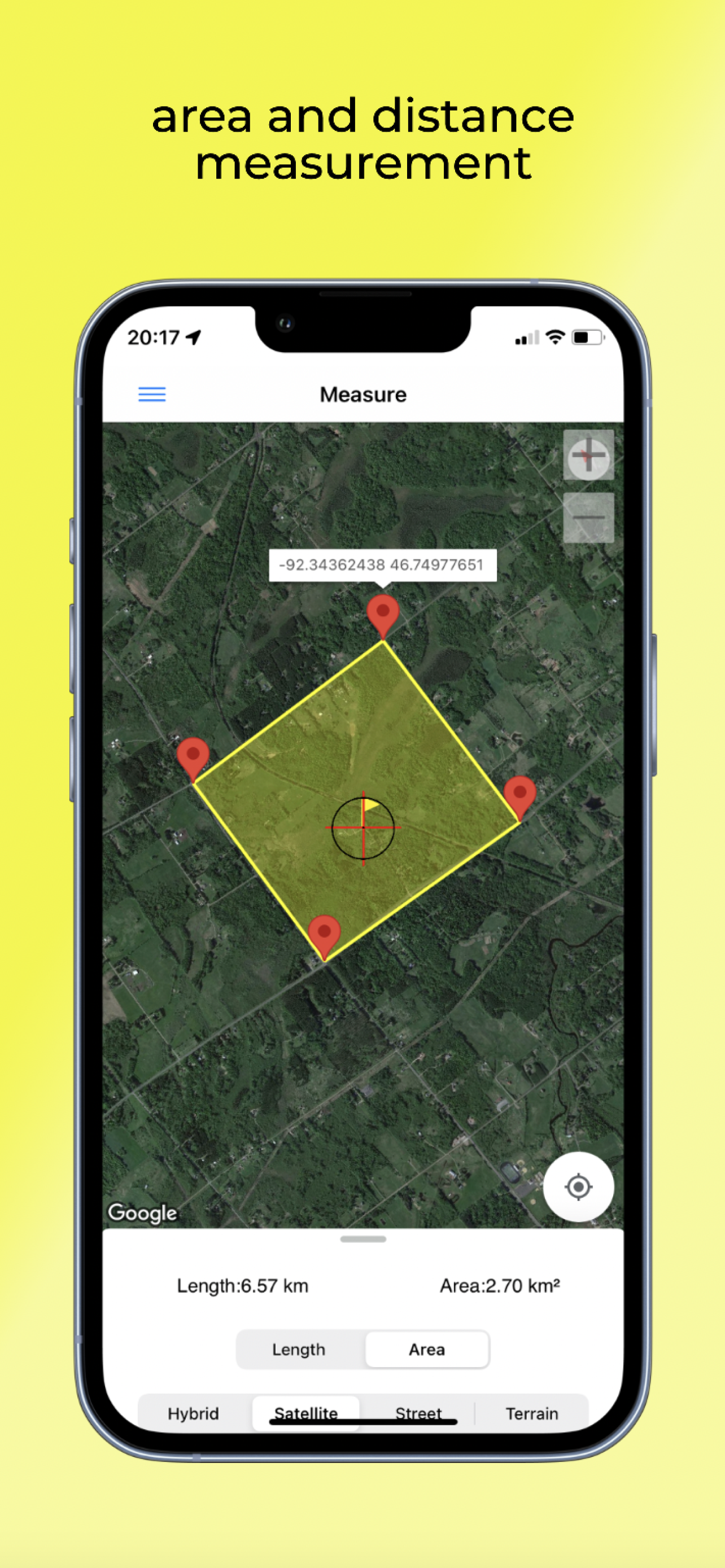
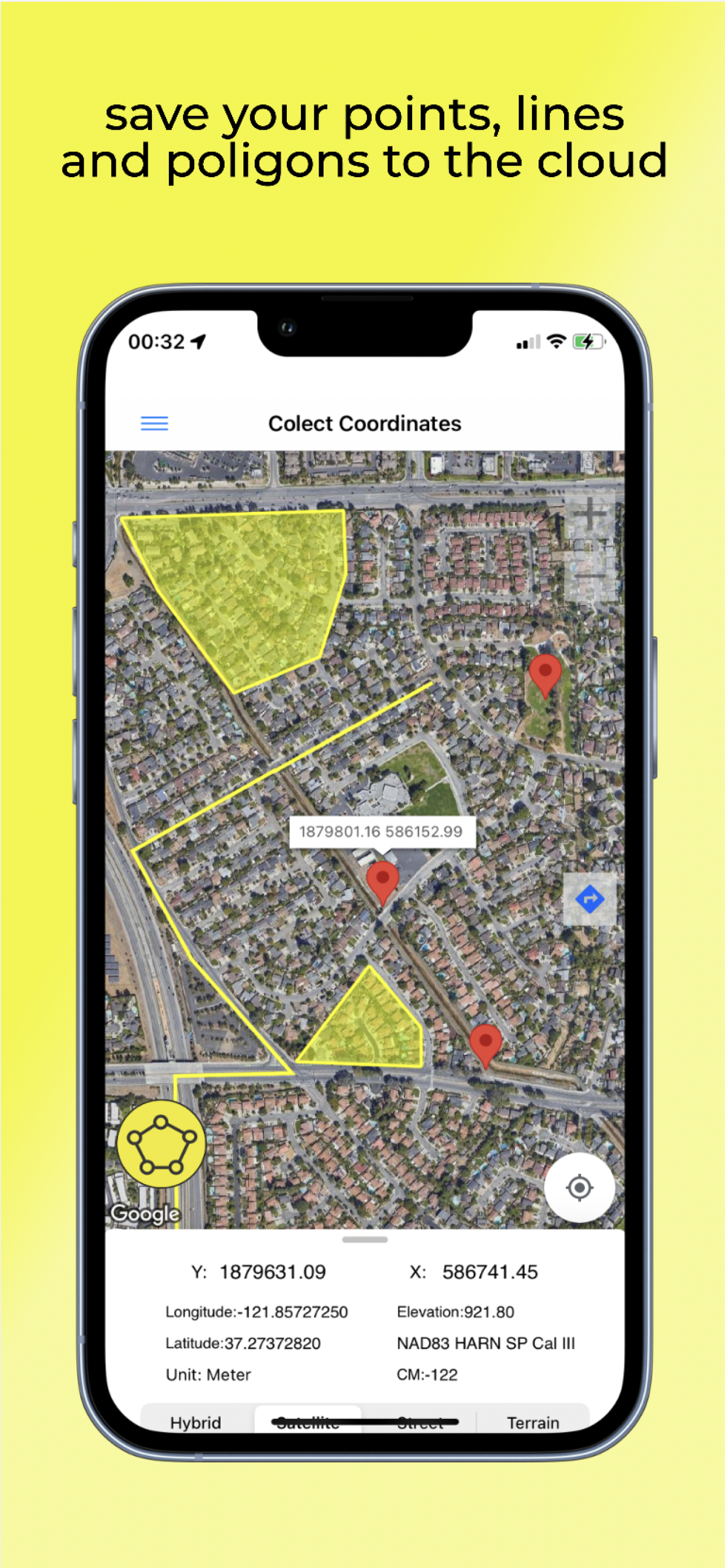
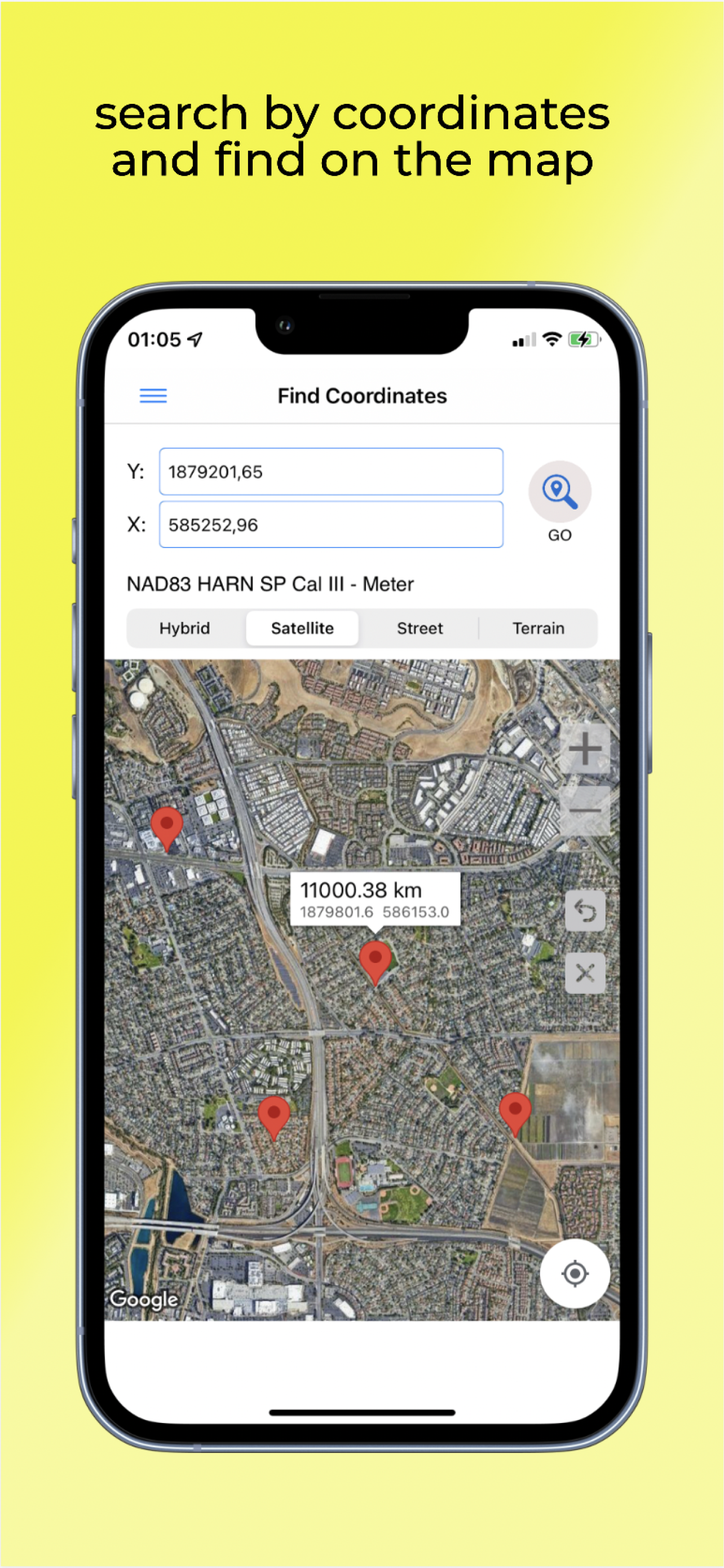
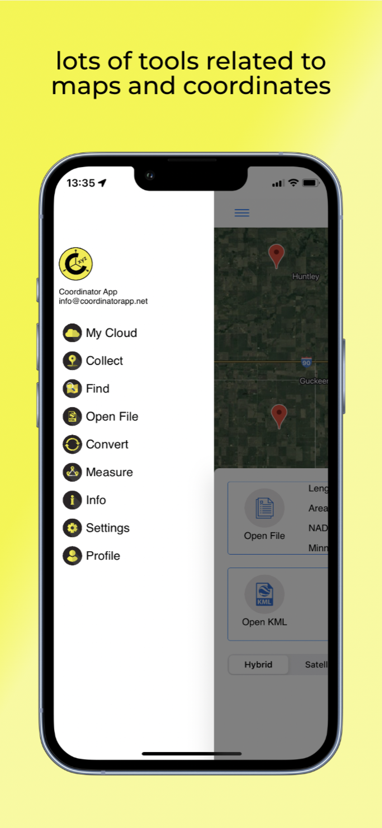
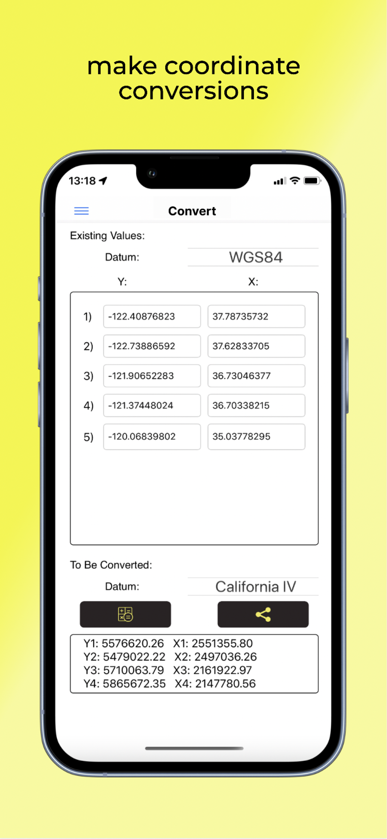
Using Coordinator app, you can collect coordinate data from land on whatever coordinate system you want, choosing from defined systems. You can collect GPS coordinates. You can use the app as a GPS tracker. You can view a coordinate data on the map. You can search by longitude/latitude. You can convert an existing coordinate into another coordinate system. You can display circumference and area measurements of some coordinates by opening the file which created before. Also you can measure distance and area for some coordinates which determined manually on the map. You can display a KML file on the map. Coordinator app contains several useful tools for people interested in coordinates, maps and geographic information systems (GIS).
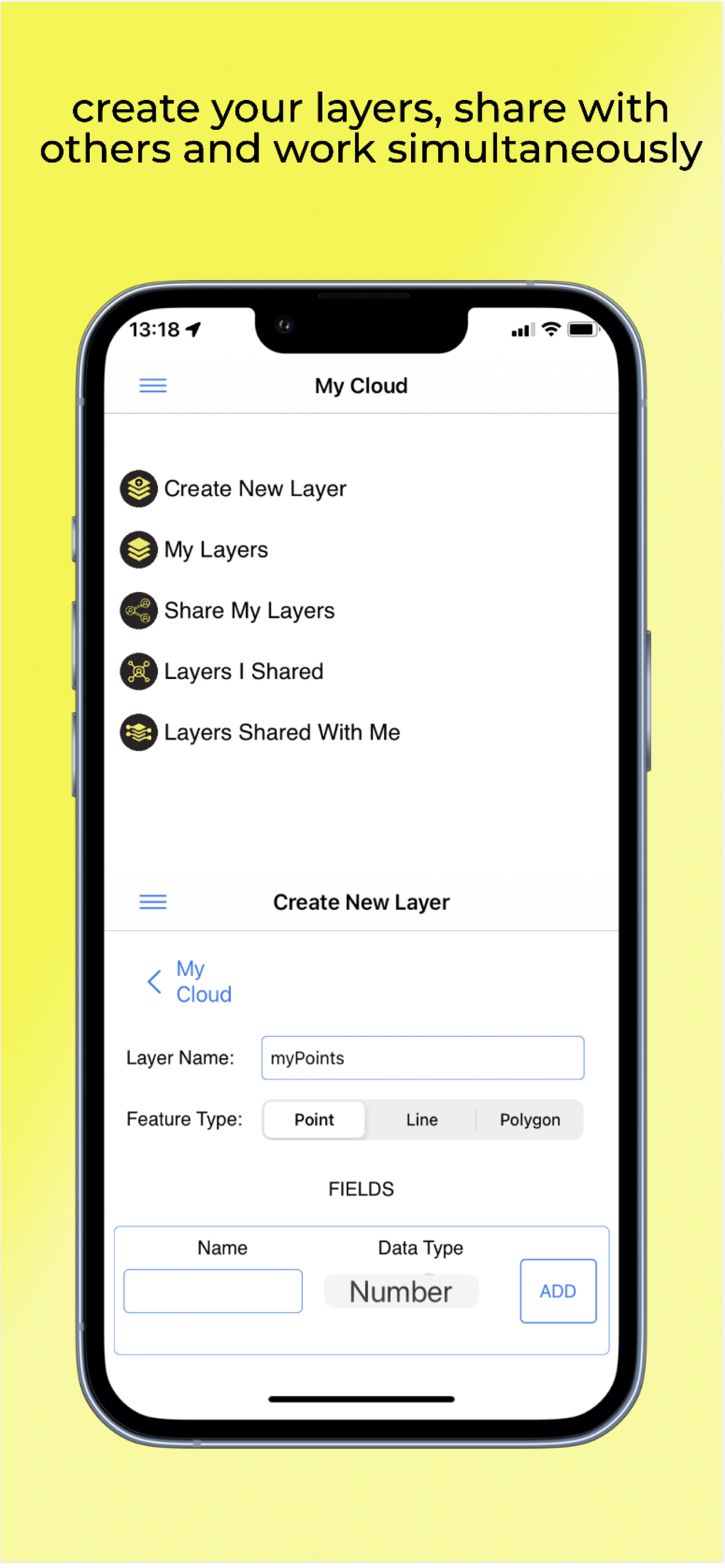
Coordinator offers Cloud Database Functions (creating points, lines & polygons, sharing your layers with teammates, working simultaneously with teammates, working offline and synchronizing, etc), exporting to KML & Excel files, get elevation value of points and so on. You can create your layers and share that layers with your teammates. You can instantaneously see the data which is created by other friends on the map instantaneously.
Besides longitude/latitude, subscribers can find out the altitude value of a point on the map. Subscribers can use the Coordinator Web app. So that you can use the cloud database features of the Coordinator app on the web page on your computer and monitor the data instantly. You can view/track and edit cloud database data on the web page. In this way, you can instantly monitor the data movements made in the mobile app in the field, in the web browser on your computer.
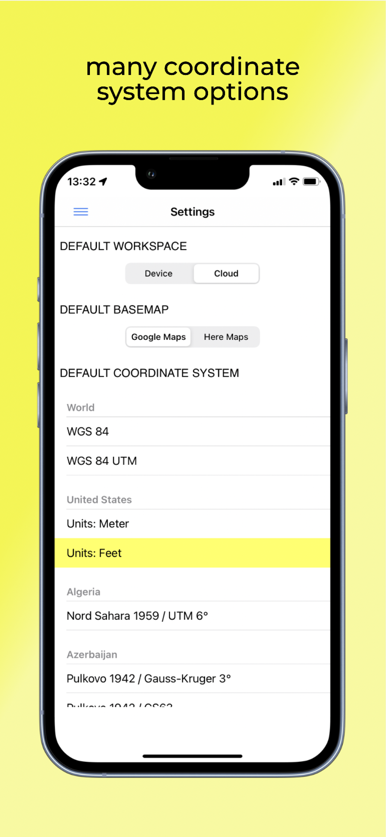
The coordinate systems of the countries, which the app is most downloaded, are added to the app.
Current list of the countries and their coordinate systems defined in this app:
World - GPS(WGS 84)
World - WGS 84 - 6 UTM
United States - "NAD 1983 HARN State Plane Coordinate Systems(meters & feet)" and "Military Grid Reference System (MGRS)"
Algeria - "Nord Sahara 1959 / UTM 6 "
Azerbaijan - "Pulkovo 1942 / Gauss-Kruger 3 " and "Pulkovo 1942 / CS63"
Bulgaria - "Pulkovo 1942(58) GK 6 "
Germany - "DHDN/3 GK" and "ETRS89 UTM 6"
India - "Kalianpur 1975 / India" and "Kalianpur 1975 / UTM 6"
Indonesia - "Indonesia 1974 UTM 6" and "DGN 1995 Indonesia TM3"
Iran - "ED50(ED77) / UTM 6"
Iraq - "Nahrwan 1967 / UTM 6" and "ED50 / Iraq National Grid" and "Karbala 1979 / UTM 6"
Israel - "Palestine 1923/Palest. Grid" and "Palestine 1923/Israeli CS Grid" and "Israel 1993/Israeli TM Grid"
Lebanon - "Deir ez Zor / Levant Ster." and "Deir ez Zor / Syria Lambert"
Mauritania - "Mauritania 1999 / UTM 6"
Morocco - "Merchich / Nord Maroc" and "Merchich / Sud Maroc"
Netherlands - "Amersfoort / RD New" and "Amersfoort / RD Old"
Palestine - "Palestine 1923/Palest. Grid" and "Palestine 1923/Israeli CS Grid" and "Israel 1993/Israeli TM Grid"
Philippines - "Luzon 1911 / Philippines" and "PRS92 / Philippines"
Romania - "Dealul Piscului 1930 / Stereo 33" and "Pulkovo 1942(58) / Stereo 70"
Russia - "Pulkovo 1942 / Gauss-Kruger 3"
Saudi Arabia - "Ain el Abd / UTM 6" and "Ain el Abd / Aramco Lambert"
Syria - "Deir ez Zor / Levant Ster." and "Deir ez Zor / Syria Lambert"
Turkey - "ITRF 96 - 3" and "ED 50 - 3" and "ITRF 96 - 6" and "ED 50 - 6"
United Arab Emirates - "Nahrwan 1967 / UTM"
By downloading and using this app, you agree to the Terms of Use at https://www.apple.com/legal/internet-services/itunes/dev/stdeula/
Hide..
Show more..
Coordinator offers Cloud Database Functions (creating points, lines & polygons, sharing your layers with teammates, working simultaneously with teammates, working offline and synchronizing, etc), exporting to KML & Excel files, get elevation value of points and so on. You can create your layers and share that layers with your teammates. You can instantaneously see the data which is created by other friends on the map instantaneously.
Besides longitude/latitude, subscribers can find out the altitude value of a point on the map. Subscribers can use the Coordinator Web app. So that you can use the cloud database features of the Coordinator app on the web page on your computer and monitor the data instantly. You can view/track and edit cloud database data on the web page. In this way, you can instantly monitor the data movements made in the mobile app in the field, in the web browser on your computer.
The coordinate systems of the countries, which the app is most downloaded, are added to the app.
Current list of the countries and their coordinate systems defined in this app:
World - GPS(WGS 84)
World - WGS 84 - 6 UTM
United States - "NAD 1983 HARN State Plane Coordinate Systems(meters & feet)" and "Military Grid Reference System (MGRS)"
Algeria - "Nord Sahara 1959 / UTM 6 "
Azerbaijan - "Pulkovo 1942 / Gauss-Kruger 3 " and "Pulkovo 1942 / CS63"
Bulgaria - "Pulkovo 1942(58) GK 6 "
Germany - "DHDN/3 GK" and "ETRS89 UTM 6"
India - "Kalianpur 1975 / India" and "Kalianpur 1975 / UTM 6"
Indonesia - "Indonesia 1974 UTM 6" and "DGN 1995 Indonesia TM3"
Iran - "ED50(ED77) / UTM 6"
Iraq - "Nahrwan 1967 / UTM 6" and "ED50 / Iraq National Grid" and "Karbala 1979 / UTM 6"
Israel - "Palestine 1923/Palest. Grid" and "Palestine 1923/Israeli CS Grid" and "Israel 1993/Israeli TM Grid"
Lebanon - "Deir ez Zor / Levant Ster." and "Deir ez Zor / Syria Lambert"
Mauritania - "Mauritania 1999 / UTM 6"
Morocco - "Merchich / Nord Maroc" and "Merchich / Sud Maroc"
Netherlands - "Amersfoort / RD New" and "Amersfoort / RD Old"
Palestine - "Palestine 1923/Palest. Grid" and "Palestine 1923/Israeli CS Grid" and "Israel 1993/Israeli TM Grid"
Philippines - "Luzon 1911 / Philippines" and "PRS92 / Philippines"
Romania - "Dealul Piscului 1930 / Stereo 33" and "Pulkovo 1942(58) / Stereo 70"
Russia - "Pulkovo 1942 / Gauss-Kruger 3"
Saudi Arabia - "Ain el Abd / UTM 6" and "Ain el Abd / Aramco Lambert"
Syria - "Deir ez Zor / Levant Ster." and "Deir ez Zor / Syria Lambert"
Turkey - "ITRF 96 - 3" and "ED 50 - 3" and "ITRF 96 - 6" and "ED 50 - 6"
United Arab Emirates - "Nahrwan 1967 / UTM"
By downloading and using this app, you agree to the Terms of Use at https://www.apple.com/legal/internet-services/itunes/dev/stdeula/
In-Apps
- 1 Year Subscription
- Rs 13,900.00
- 1 Month Subscription
- Rs 1,400.00
Screenshots
 User Rating
0 out of 5
0 ratings in Pakistan
Ratings History
Reviews
App doesn't have any reviews yet
Store Rankings
Ranking History
App Ranking History not available yet
Category Rankings
|
Chart
|
Category
|
Rank
|
|---|---|---|
|
Top Grossing
|
|
14
|
|
Top Grossing
|

|
47
|
|
Top Free
|
|
47
|
|
Top Grossing
|

|
74
|
|
Top Grossing
|

|
85
|
Keywords
Users may also like
| Name | Reviews | Recent release | |
|---|---|---|---|

Map Plus
A Powerful Map and GIS tool
|
1
|
2 months ago | |

Tomstrails GPS UTM
UTM Grid Reference
|
1
|
2 years ago | |

Altimeter: Elevation, Compass
Altitude Barometer GPS Tracker
|
0
|
8 months ago | |

Mgrs & Utm Map
|
0
|
3 weeks ago | |

Military GPS Survival Kit
MGRS SAR Tactical Navigation
|
0
|
2 months ago | |

KML Collection: Import Maps
Import and edit your own maps
|
0
|
2 weeks ago | |

GPS Coordinates Finder
Find GPS coordinates easily
|
0
|
2 years ago | |

Trafik Ceza Rehberi 2024
Trafik Ceza Rehberi 2024
|
0
|
4 months ago | |

CarryMap
Offline maps & data collection
|
0
|
2 months ago | |

Topograf Parsel Sorgu 2024
|
0
|
3 months ago |
Show More
Revenue and Downloads
Gain valuable insights into Coordinator + performance with our analytics. Sign up now
to
access downloads, revenue, and more.
App Info
- Category
- Navigation
- Publisher
- Suleyman ER
- Languages
- English, Turkish
- Recent version
- 3.2.2 (5 months ago )
- Released on
- May 19, 2020 (4 years ago )
- Also available in
- Turkey, Indonesia, United States, Finland, France, Romania, Mexico, New Zealand, Norway, Netherlands, Nigeria, Malaysia, Philippines, Lebanon, Kazakhstan, Kuwait, South Korea, Japan, Peru, India, Pakistan, Poland, Portugal, Russia, Saudi Arabia, Sweden, Singapore, Thailand, Taiwan, Ukraine, Vietnam, South Africa, Germany, Argentina, Austria, Australia, Azerbaijan, Belgium, Brazil, Belarus, Canada, Switzerland, Chile, China, Colombia, Czechia, Italy, Denmark, Dominican Republic, Algeria, Ecuador, Egypt, Spain, United Kingdom, Greece, Hong Kong, Hungary, Ireland, Israel, United Arab Emirates
- Last updated
- 1 day ago