Team awareness issues
Not working again, iOS 13P max

Yes, DroneDeploy Flight App is completely free and it doesn't have any in-app purchases or subscriptions.
🤔 The DroneDeploy Flight App app's quality is mixed. Some users are satisfied, while others report issues. Consider reading individual reviews for more context.
DroneDeploy Flight App is free.
To get estimated revenue of DroneDeploy Flight App app and other AppStore insights you can sign up to AppTail Mobile Analytics Platform.

4.64 out of 5
367 ratings in Canada
Not working again, iOS 13P max
This app has been very glitchy and inconsistent for me. It constantly loses the drones position, cuts the video feed and often closes the app during flight. Last week while using the app my drone randomly fell from the sky and crashed. Dronedeploy needs to resolve these issues before I can recommend it.
Tried to contact tech support, all that is there is an AI chat bot, so no help there. Combined with the RIDICULOUSLY high per month price, I won’t be using this anytime soon. Too bad, as it looked promising. App is unuseable on my IPad
I like everything about this this is perfect for my job it does it automatically and autonomously this is so easy to use but to keep using it I need to pay a ridiculous price a month I know if you use the Mavic pro you can make a 2D map for free wanted to see if this would work with my air 2S so I select it and no warnings up here which means I wanted to see if this would work I brought it to the field and when I tried to take off it said drone not supported unlock all features to use which was damn it should’ve warned you before you wasted your time charging batteries to see if it would work this is more for people that have lots of money to waste so I will still manually make 3-D maps with my drone I hope the prices drop in the future
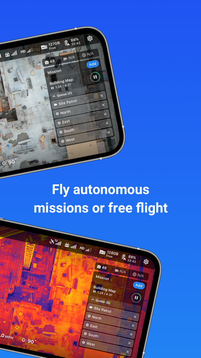
This app has potential but a number of things bug me. 1) no time or apple phone power is shown in the menu while flying. Would be handy to know 2) I’m working in a remote location where service does not exist. I lost a few pilot logs already because the app will crash before I have a chance to get back into wifi. Would be nice if it actually stored the pilot log until I want to delete it. 3) be careful when planning flight plans. If the line isn’t parallel to your tracks then it wont snap pictures. 4) no way to change your start position and if there is then it’s not easy to find. 5) flight plans can’t be adjusted to 270 degrees, just 0,90,180 making it challenging at times. Would be nice if the next version had these updates.
I get “Plan upload failed: There is not a mission available”.
We are doing photogrammetry for the upcoming HBO “The Last of Us”, and the Drone Deploy mapping app has worked perfectly for us. Our only note would be to have exposure control w/in the app, so not having to use the DJI Go4 app prior since our mapping is of large areas & lighting changes happen over time. Main issue w/ using the Drone Deploy auto exposure is its using a 1/60th shutter which is way too slow for quality sharpness, needs to be at least 1/125th and an aperture between f4.0 & f8.0 @ iso 100-400. But saying that, going back and forth beteen the apps isn’t a big deal, but does mess up sometimes.
Drone Deploy has completely revamped their service. I used to shutter at the thought of using D.D. It was buggy, it would crash mid mission with the drone in the air. Some of the buttons in the app wouldn’t even display properly. After giving them a chance 3 years later, I am greatly impressed with how much work the D.D team did to get back on track. More features, ease of use and great price point have brought drone deploy back. They even provide more for less cash than other subscription services.
Each flight was in the order of 10-15 minutes with many-many hundred of photos taken. The Drone was out of sight for a good portion of some flights, due mostly to extensive tall trees is one area I was mapping. I know not to the ‘rules’ but all flights were in very remote areas. When I did fly over a property, with houses, I did get prior permission from the owners and gave them copies of the results, they were all very happy. The realtime moving map on my iPhone X worked extremely well and gave me confidence that I could recover the Drone manually, if required. I used a homemade sun-shade, cardboard and duct-tape to better see the screen. The final products came back quickly. I had a series of 6 GCP deployed on one flight, but my Surveyor Dude fell through so I could not test the accuracy improvements using the Ground Control Points.
App does not even load i,wouldn't trust this with my expensive drone.Much better options out there that work.
|
Chart
|
Category
|
Rank
|
|---|---|---|
|
Top Free
|

|
352
|
|
Top Free
|

|
416
|
|
Top Free
|

|
452
|
|
Top Free
|

|
454
|
|
Top Free
|

|
471
|

