DroneSense
Public Safety Drone Platform
#1 Keyword Rankings
Today
Top 10 Rankings
Today
Top 30 Rankings
Today
Top 100 Rankings
Today
Description
For UAS Pilots -
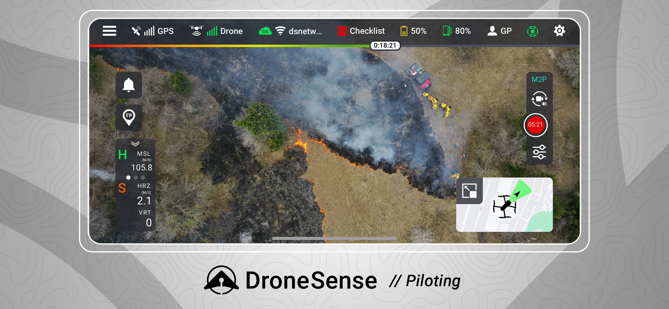
Fly a wide range of professional drones with DroneSense! Simply download this app directly onto your iPad and plug directly into any drone remote. Incorporating the latest and greatest drone is easy; there is no new training as the pilot will always fly with our app and have the same experience, no matter what drone is chosen. Share your live video stream with incident commanders easily to enable increased situational awareness on-scene. Automated flight logging ensures all data from all flights are available at any time.
For Program Administrators -
DroneSense is your complete system of record. It is a complete asset and risk management tool that provides accountability and transparency across your organization. Organize your people, hardware, and flight history in a powerful but intuitive interface. Whether it is automatically logging flight hours, filing NOTAMs, or managing personnel, DroneSense is your one-stop solution. Our software lets you quickly leverage all your resources so you can spend more time focused on the mission at hand.
For Incident Commanders -
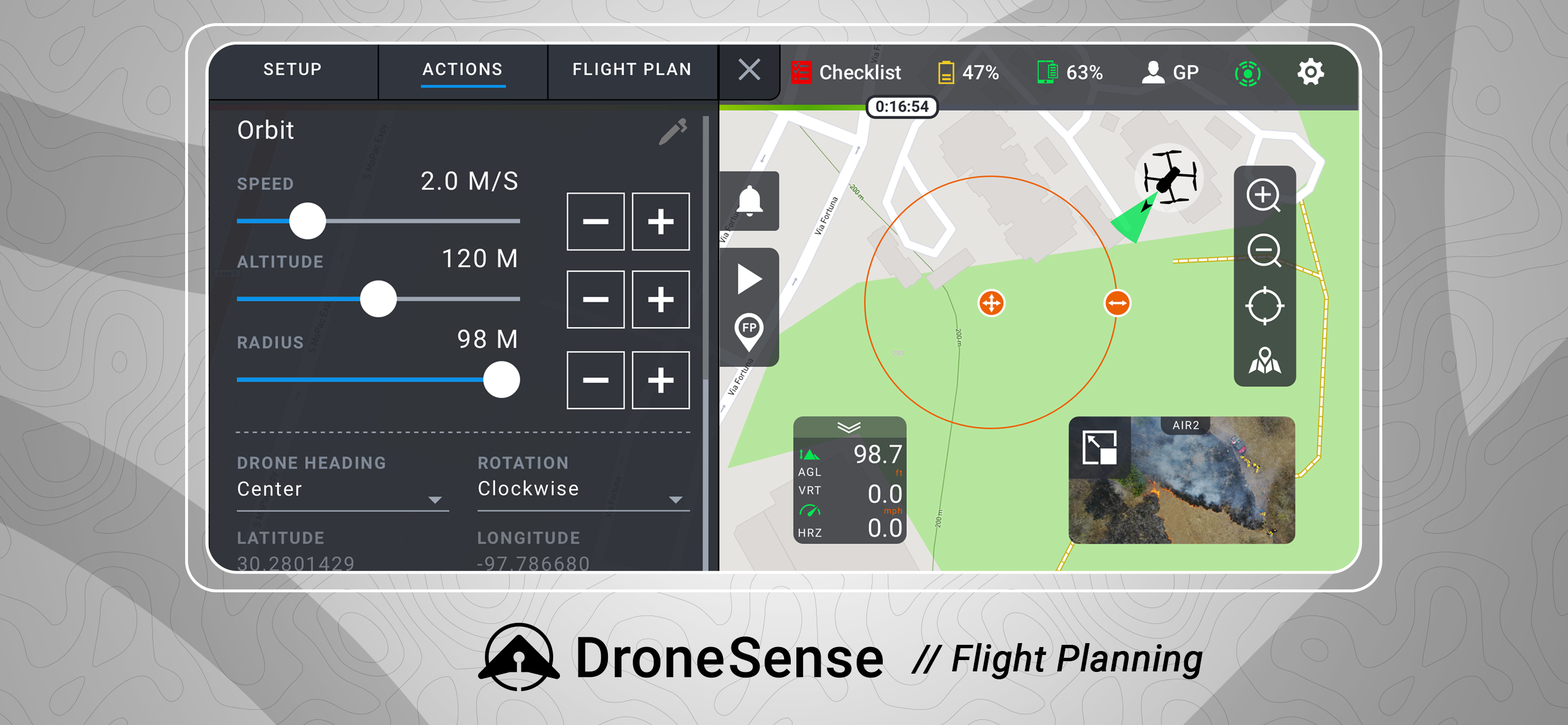
DroneSense gives incident commanders and remote stakeholders the power to strategize and tactically collaborate. Our Operations Hub enables you to share real-time, low-latency, high definition views of a scene and plan dynamically. Anyone with a connected device can see a live pilot session, and multiple drone pilots can work together seamlessly.
Please note that usage of the DroneSense Platform requires user registration and authorization from accredited public safety agencies.
Hide..
Show more..
Fly a wide range of professional drones with DroneSense! Simply download this app directly onto your iPad and plug directly into any drone remote. Incorporating the latest and greatest drone is easy; there is no new training as the pilot will always fly with our app and have the same experience, no matter what drone is chosen. Share your live video stream with incident commanders easily to enable increased situational awareness on-scene. Automated flight logging ensures all data from all flights are available at any time.
For Program Administrators -
DroneSense is your complete system of record. It is a complete asset and risk management tool that provides accountability and transparency across your organization. Organize your people, hardware, and flight history in a powerful but intuitive interface. Whether it is automatically logging flight hours, filing NOTAMs, or managing personnel, DroneSense is your one-stop solution. Our software lets you quickly leverage all your resources so you can spend more time focused on the mission at hand.
For Incident Commanders -
DroneSense gives incident commanders and remote stakeholders the power to strategize and tactically collaborate. Our Operations Hub enables you to share real-time, low-latency, high definition views of a scene and plan dynamically. Anyone with a connected device can see a live pilot session, and multiple drone pilots can work together seamlessly.
Please note that usage of the DroneSense Platform requires user registration and authorization from accredited public safety agencies.
Screenshots
 User Rating
0 out of 5
0 ratings in Canada
Ratings History
Reviews
App doesn't have any reviews yet
Store Rankings
Ranking History
App Ranking History not available yet
Category Rankings
App is not ranked yet
Keywords
Users may also like
| Name | Reviews | Recent release | |
|---|---|---|---|

FlyQ EFB
|
4
|
2 months ago | |

Airmate
Flight planning/weather
|
7
|
1 week ago | |

CalTopo
Backcountry mapping evolved
|
5
|
2 weeks ago | |
iTAK
Team Awareness Kit
|
2
|
1 month ago | |

AeroNOTAM
Get NOTAMs simple and quick
|
3
|
5 months ago | |

SkyCharts XC EFB
Geo plates and charts
|
0
|
7 months ago | |

Pro Altimeter - Barometric+GPS
Manual/GPS/METAR Calibration
|
1
|
3 months ago | |

AeroADSB
Shows ADS-B aircraft traffic
|
0
|
6 months ago | |

Dronetag
|
0
|
2 weeks ago | |

Aerial Armor
Drone Detection Solutions
|
1
|
5 months ago |
Show More
Revenue and Downloads
Gain valuable insights into DroneSense performance with our analytics. Sign up now
to
access downloads, revenue, and more.
App Info
- Category
- Navigation
- Publisher
- DroneSense INC
- Languages
- English
- Recent version
- 2024.5.1 (1 month ago )
- Released on
- Aug 14, 2023 (10 months ago )
- Also available in
- United States, Finland, Australia, Canada, Spain, United Kingdom, Netherlands, New Zealand, Poland, Sweden, South Africa, Norway
- Last updated
- 4 weeks ago