EasyTrails GPS
#1 Keyword Rankings
Today
Top 10 Rankings
Today
Top 30 Rankings
Today
Top 100 Rankings
Today

Description

EasyTrails GPS is the GPS tracker application for your iPhone.
The perfect application for those who are passionate about OUTDOOR ACTIVITIES and TRAVELING, everybody who likes outdoor sports, and not only.

Are you going for a bike or motorcycle ride? Well, EasyTrails GPS will tell you how many miles you traveled, how much time you spent, how high you climbed and many other details. In real-time it will show you the course on a map, comparing it with downloaded tracks and points of interest.

You can import or share all tracks and waypoints, photos and ideas for new journeys with your friends.

Share where you are on Facebook and Twitter through your GPS position, and export your tracks in standard formats, so you can review them on Google Earth, SportTracks and TrailsRunner. Or simply upload them to online services like Garmin Connect, or many others.

It's possible to import tracks by e-mail or Safari (EasyTrails can handle GPX, KML/KMZ and ZIP file formats), or by wi-fi networks, using an improved and easy to use web-based sharing feature.

Calculate routes and let EasyTrails guide you using the new navigation capabilities. You can also let it guide you through previously recorded tracks.
Additionally, EasyTrails GPS can communicate with navigators like Maps, Google Maps, TomTom or Waze (if installed) for more advanced guidance needs.

Load custom cartography, EasyTrails supports KMZ and MBTILES formats.

EasyTrails GPS is easy to use and extremaly accurate. It ensures the maximum duration of battery thanks to the possibility of recording in "StandBy" mode. However, be aware that use of GPS, even in background, will have a significant impact on battery duration.

► For more info, visit our website: www.easytrailsgps.com


NEW FEATURES:

► Heart rate monitoring (paid)

We added the ability to connect to compatible Bluetooth heart rate monitors (such as Polar H6 and H7 devices). Heart rate can be seen in real time from the dashboard.

With the 'Heart rate monitoring' in-app purchase:
- heart rate data will be associated to GPS tracks
- saved tracks will have an extra heart rate chart
- heart rate data will be saved to HealthKit

Additionally, with the 'Colored tracks' in-app purchase, it will be possible to highlight heart rate data directly on the map screen of a recorded track.

OTHER FEATURES:

- Support for many different map types
- Support for different coordinate systems
- Support for user-loaded offline cartography (KMZ and MBTILES)
- Export tracks (single or multiple) in standard formats (GPX, KML/KMZ and CSV), with their associated waypoints and pictures
- Import tracks (GPX and KML/KMZ)
- Import waypoints (GPX and KML/KMZ)
- Resume recording of tracks
- Save waypoints with photos and descriptions
- Navigate to a point of interest
- Sharing via Facebook and Twitter
- Follow a path/track
- Navigate (distance / direction) towards any waypoint
- Navigate (distance / direction) towards any track marker (start / pause / resume / end points)
- Advanced Navigation to a waypoint using any navigation app you may have installed
- Upload tracks to GPSies (http://www.gpsies.com)
- Upload tracks to SportTracks (http://sporttracks.mobi)
- Upload tracks to OpenTrail (http://www.opentrail.us)
- Upload tracks to OkMap (http://www.okmap.org)
- Real-time visualization of distance, speed, altitude bearing and other data
- Map Visualization in different modes: street map, satellite, hybrid, terrain
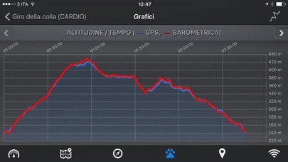
- Charts (elevation profiles, ...)
- Digital Compass
- Heart rate monitoring
- Turn by turn directions
- High battery duration (record in standby)
- Select between metric, imperial and nautical measuring systems
- Intuitive and User Friendly interface
- Lightweight, reliable and accurate
- Doesn't require internet connection

Terms of Use: https://www.apple.com/legal/internet-services/itunes/dev/stdeula/
Privacy Policy: http://www.easytrailsgps.com/wp-content/uploads/2016/05/EasyTrails-GPS-Privacy-Policy.pdf
Hide.. Show more..

Screenshots

User Rating

4.58 out of 5

19 ratings in Netherlands

5 star
15
4 star
2
3 star
1
2 star
0
1 star
1

Ratings History

Reviews

Uitstekend

JILR on

Werkt nauwkeurig (veel beter dan bijv Strava) en betrouwbaar of je nu fietst, wandelt of skiet. Duidelijke interface. Grafieken met afstand/hoogte/snelheid ook cool. Aanrader!

Super app

Encryptie on

Ik gebruik hem al jaren op mijn iPhone. Nog nooit vastgelopen. Zeer goede kaarten. Ook tijdens het wandelen door het bos of in de weide waar de paadjes soms niet duidelijk zichtbaar zijn. Dan wijst EasyTrails me altijd de weg. Ik kan niet meer zonder. Maar sedert de update naar IOS 13 worden de routes in gpx door Safari niet meer aan EasyTrails gelinked. Dus worden ze ook niet meer in easytrails geopend. En dat is zeer vervelend.

Onbetrouwbare app

The Tui's on

M’n hele vakantie trail is mislukt. De app loopt steeds vast en dan ben ik m’n trail kwijt. In een vakantie van 3 weken ben ik meer dan de helft van alle registraties kwijtgeraakt. Ik baal als een stekker.

Very good

Passat63 on

The UI is, at first, a bit confusing. But, more importantly, the app does what it is supposed to do in a very accurate way without drowning the battery: 60% for a full dat track. Highly recommended.

Goede app

Jaap63 on

Gebruik deze zowel op ipad als I phone, gps is nauwkeurig en werkt prima. Handig dat je kunt kiezen voor meerdere kaartsoorten

Jammer

Gerard1952 on

Jammer dat de app regelmatig vastloopt als je waypoints van foto wil voorzien, ook het wijzigen van waypoints verloopt moeizaam, anders gaf ik zeker 5 sterren voor deze app, ook het bekijken van de fotos van de waypoints en waar ze op de kaart staan werkt niet, echt heel jammer.

Uitstekend

funnel20 on

De eerste App die ik ooit kocht, toen nog op mijn iPhone 3G. Inmiddels vele iPhones verder, gaan alle opgenomen tracks mee. De vele updates maken de App steeds beter, en vooral zuiniger qua batterij gebruik. Zo'n 5 uur loggen tijdens wandelen kost iets van 10-15% batterij op mijn iPhone 6. Zeer acceptabel.

Easy trail gps

Hoedendoos on

If you have any problems you get immediately a reply with advice. Very helpful.

Top app

Eindelijk daar is ie dan !!!!!!! on

Wat een geweldige app een must voor de fietser die zelf routes wil plannen. Ik gebruik routeplanner van de fietsersbond en importeer deze in Easy Trails 6. Je kunt dan simpel het lijntje op de kaart volgen. als je de route opneemt dan kun je naderhand ook nog zien hoe je de route hebt afgelegd. de snelheid is niet geheel stabiel middelste scherm hierboven en verspringt een beetje maar dat gebruik je toch niet want je zit toch bijna altijd in het linker scherm de map te kijken. Een must voor de fietser. Een 10 wat mij betreft.

Echt goed

Gulzt on

Mijn vriendin en ik gebruiken de app voor inline-skate routes. Prachtig om terug te zien op Google maps hoe we gereden zijn. Zelfs de positie op de weg is zichtbaar, erg gedetailleerd. Rollen we zigzaggend van de linker naar de rechter weghelft zie je een keurige zaagtand figuur. Grafiek afstand / tijd, gemiddelde snelheid / tijd is mooi weergegeven en wederom gedetailleerd. Helaas is de hoogte registratie een puinhoop. Op vlakke wegen komen pieken en dalen voor van 18 tot 24 meter. Dat is dus nog een verbeterpuntje, maar voor ons weinig belangrijk. Aanrader dus!

Store Rankings

Ranking History

App Ranking History not available yet

Category Rankings

Chart
Category
Rank
Top Paid
5
Top Paid
7
Top Paid
9
Top Paid
9
Top Paid
12

Keywords

Revenue and Downloads

Gain valuable insights into EasyTrails GPS performance with our analytics. Sign up now to access downloads, revenue, and more.

App Info

Category
Sports
Publisher
Zirak Srl
Languages
English, Dutch, French, German, Italian, Portuguese, Russian, Chinese, Spanish
Recent version
11.8 (1 week ago )
Released on
Apr 2, 2012 (12 years ago )
Last updated
3 weeks ago