
Elevation For Real
#1 Keyword Rankings
Today
Top 10 Rankings
Today
Top 30 Rankings
Today
Top 100 Rankings
Today
Description
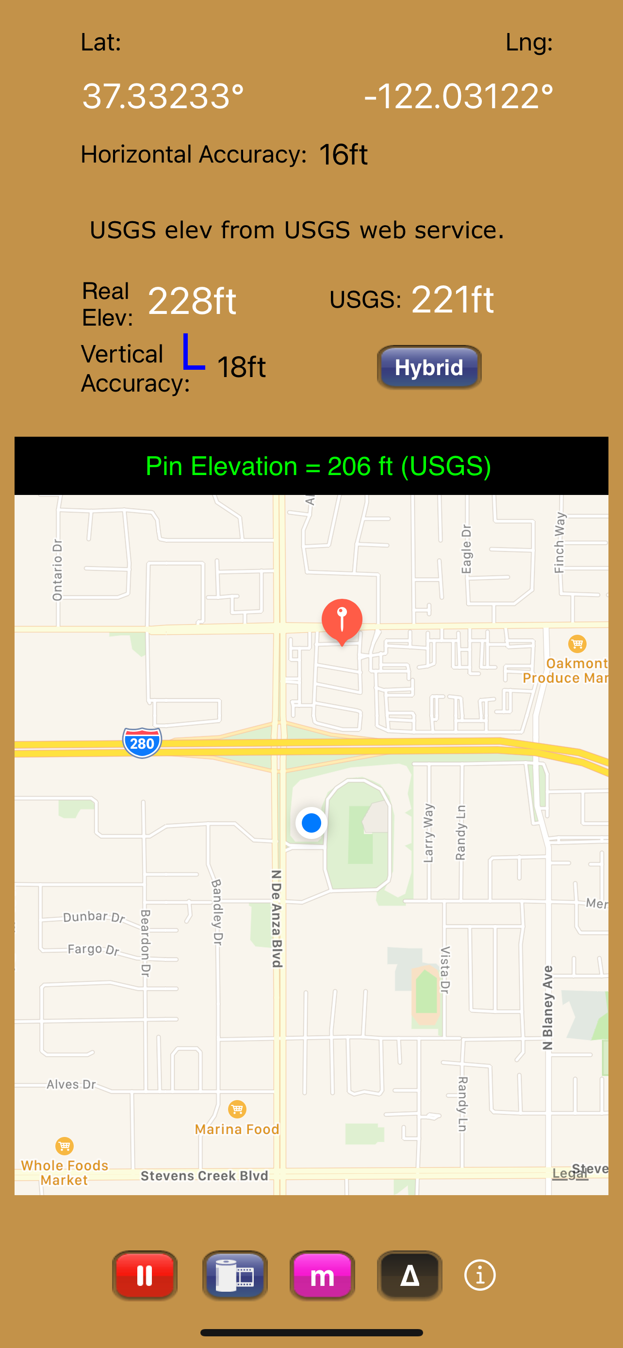
Get real-time elevation from your iOS device's GPS receiver and built-in geoid model.
As a bonus, we've also included access to the USGS Elevation Web Service which provides US ground elevation data. You'll be amazed at how, when you have a good view of the sky, Elevation For Real's internally generated elevation converges on the USGS value after just a short time. Outside the U.S., or on iOS devices with non-U.S. region settings, or if the USGS elevation service is unavailable, Shuttle Radar Topography Mission (SRTM) published elevation data is shown between 60°N and 56°S latitude.
Here are some more features:
- Real-time map which displays your location
- Estimated vertical and horizontal accuracy
- Spot elevation data displayed by tapping map
- English or metric units based on your region setting
- Start/Stop button
- One touch screenshots
- NO Third-Party Ads!
- Optional pressure altimeter (in-app purchase). Measure relative altitudes or calibrate to an elevation benchmark. Use indoors or out. Even works in Airplane Mode! Note: your iOS device must be equipped with a barometer to access pressure altimeter functionality. The iPhone 6 and later and the iPad Air 2 and later have barometers.
Download Elevation For Real today!
Notes:
1) homedatasheet.com, Inc. is not affiliated with USGS. USGS Elevation Web Service is available to the general public online, at no cost.
2) SRTM is provided by geonames.org. homedatasheet.com, Inc. is not affiliated with geonames.org. U.S.-based users should note that, in many instances, the SRTM data is not as accurate as USGS data. All users should note that, in certain locations, the SRTM dataset may be tens of meters or more in error.
3) ***The initial view of this app requires a GPS signal to work properly. A clear view of the sky is needed for GPS reception, and it may take several seconds to get a position fix. Elevation for Real will run on devices not equipped with a GPS receiver and GPS-equipped devices that are not receiving a GPS signal, but any resulting elevation readings will just be the approximate ground elevation at your location, even if you are several stories up in a tall building.
4) ***Any elevation measurements with personal safety or financial implications should be performed by professionals with professional GPS equipment. Elevation for Real is not intended to determine flood hazard. Consult a licensed professional in your jurisdiction, such as a surveyor or engineer, when dealing with flood risk.
Hide..
Show more..
As a bonus, we've also included access to the USGS Elevation Web Service which provides US ground elevation data. You'll be amazed at how, when you have a good view of the sky, Elevation For Real's internally generated elevation converges on the USGS value after just a short time. Outside the U.S., or on iOS devices with non-U.S. region settings, or if the USGS elevation service is unavailable, Shuttle Radar Topography Mission (SRTM) published elevation data is shown between 60°N and 56°S latitude.
Here are some more features:
- Real-time map which displays your location
- Estimated vertical and horizontal accuracy
- Spot elevation data displayed by tapping map
- English or metric units based on your region setting
- Start/Stop button
- One touch screenshots
- NO Third-Party Ads!
- Optional pressure altimeter (in-app purchase). Measure relative altitudes or calibrate to an elevation benchmark. Use indoors or out. Even works in Airplane Mode! Note: your iOS device must be equipped with a barometer to access pressure altimeter functionality. The iPhone 6 and later and the iPad Air 2 and later have barometers.
Download Elevation For Real today!
Notes:
1) homedatasheet.com, Inc. is not affiliated with USGS. USGS Elevation Web Service is available to the general public online, at no cost.
2) SRTM is provided by geonames.org. homedatasheet.com, Inc. is not affiliated with geonames.org. U.S.-based users should note that, in many instances, the SRTM data is not as accurate as USGS data. All users should note that, in certain locations, the SRTM dataset may be tens of meters or more in error.
3) ***The initial view of this app requires a GPS signal to work properly. A clear view of the sky is needed for GPS reception, and it may take several seconds to get a position fix. Elevation for Real will run on devices not equipped with a GPS receiver and GPS-equipped devices that are not receiving a GPS signal, but any resulting elevation readings will just be the approximate ground elevation at your location, even if you are several stories up in a tall building.
4) ***Any elevation measurements with personal safety or financial implications should be performed by professionals with professional GPS equipment. Elevation for Real is not intended to determine flood hazard. Consult a licensed professional in your jurisdiction, such as a surveyor or engineer, when dealing with flood risk.
In-Apps
- Pressure Altimeter
- SAR 4.99
Screenshots

 User Rating
1 out of 5
1 ratings in Saudi Arabia
5 star
0
4 star
0
3 star
0
2 star
0
1 star
1
Ratings History
Reviews
Store Rankings
Ranking History
App Ranking History not available yet
Category Rankings
App is not ranked yet
Keywords
Users may also like
| Name | Reviews | Recent release | |
|---|---|---|---|

Terrain Radar Altimeter
Altimeter with elevation chart
|
0
|
6 months ago | |

My Altitude and Elevation GPS
Elevation over surface.
|
0
|
5 days ago | |
|
Elevation - Altimeter Map
Find your altitude on the map
|
2
|
1 week ago | |

Topo Nomad
USGS Topographical Maps
|
0
|
1 year ago | |

Topo Reader
USGS Topographical Maps
|
0
|
1 year ago | |

Pro Altimeter - Barometric+GPS
Manual/GPS/METAR Calibration
|
0
|
3 months ago | |

Altitude measurement
elevation, height above sea
|
1
|
2 years ago | |

Altimeter - altitude and more
Altitude, location, navigation
|
0
|
1 week ago | |

Map Altimeter
Altitude Here and There
|
0
|
1 year ago | |

Altimeter Tracker
New! Pro grade alti tracking.
|
0
|
10 months ago |
Show More
Revenue and Downloads
Gain valuable insights into Elevation For Real performance with our analytics. Sign up now
to
access downloads, revenue, and more.
App Info
- Category
- Navigation
- Publisher
- homedatasheet.com, Inc.
- Languages
- English
- Recent version
- 10.0 (9 months ago )
- Released on
- Dec 29, 2009 (14 years ago )
- Also available in
- United Kingdom, United States, Australia, Chile, Argentina, Thailand, Saudi Arabia, Philippines, Netherlands, Japan, Italy, Israel, Ireland, Hong Kong, France, Spain, Germany, Canada, Austria, Switzerland, Sweden, Nigeria, Brazil, Peru, Belgium, Poland, Romania, Azerbaijan, Malaysia, Singapore, Turkey, Taiwan, Ukraine, United Arab Emirates, Vietnam, South Africa, Colombia, Ecuador, Egypt, Dominican Republic, Denmark, Greece, Czechia, Hungary, Indonesia, Algeria, China, India, South Korea, Kuwait, Lebanon, Mexico, Portugal, Pakistan
- Last updated
- 1 week ago