
Description
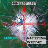
Elevation Tracker allows you to track your altitude in real-time and visualize the elevation along your route.
Altitude measurements are obtained from your phone's internal GPS sensor, offering optimal accuracy outdoors and in open areas.
Features include:
- Live altitude display
- Altitude tracking on a map in satellite, hybrid, or normal mode
- Choice of measurement units between meters and feet
- Selection of altitude reference
- Real-time display of GPS coordinates
- Ability to share & export your location and altitude data
- Customization of your route display according to your preferences
The app works perfectly without an internet connection.
Download Elevation Tracker today to keep control of your altitude and route!
Hide
Show More...
Altitude measurements are obtained from your phone's internal GPS sensor, offering optimal accuracy outdoors and in open areas.
Features include:
- Live altitude display
- Altitude tracking on a map in satellite, hybrid, or normal mode
- Choice of measurement units between meters and feet
- Selection of altitude reference
- Real-time display of GPS coordinates
- Ability to share & export your location and altitude data
- Customization of your route display according to your preferences
The app works perfectly without an internet connection.
Download Elevation Tracker today to keep control of your altitude and route!
Screenshots


Elevation Tracker FAQ
-
Is Elevation Tracker free?
Yes, Elevation Tracker is completely free and it doesn't have any in-app purchases or subscriptions.
-
Is Elevation Tracker legit?
Not enough reviews to make a reliable assessment. The app needs more user feedback.
Thanks for the vote -
How much does Elevation Tracker cost?
Elevation Tracker is free.
-
What is Elevation Tracker revenue?
To get estimated revenue of Elevation Tracker app and other AppStore insights you can sign up to AppTail Mobile Analytics Platform.

User Rating
App is not rated in Japan yet.
Ratings History
Elevation Tracker Reviews
Store Rankings
Ranking History
App Ranking History not available yet
Category Rankings
|
Chart
|
Category
|
Rank
|
|---|---|---|
|
Top Free
|

|
495
|
Elevation Tracker Competitors
| Name | Downloads (30d) | Monthly Revenue | Reviews | Ratings | Recent release | |
|---|---|---|---|---|---|---|

高度計GPS - 地図、コンパス&気圧計付き
オフライン地形ハイキングマップ, 座標, 経度, 緯度
|
View
|
View
|
17
|
|
4 months ago | |

Altimeter X Lite
GPS altitude
|
View
|
View
|
0
|
|
10 months ago | |

Offline Maps: GPS Tracker GPX
Navigation, Сompass, Pedometer
|
View
|
View
|
0
|
|
4 months ago | |
MapTool - GPS, Compass, Altitu
|
View
|
View
|
0
|
|
10 years ago | |

Baloc - 気圧計 GPSトラッキング
高度プロファイルの記録
|
View
|
View
|
0
|
|
2 weeks ago | |

karta höjdmätare
|
View
|
View
|
0
|
112
|
2 weeks ago | |

Cuspart: 高度計
高度計、気圧計、GPS
|
View
|
View
|
0
|
|
3 weeks ago | |

GPS 高度
高度計およびバロメーター
|
View
|
View
|
0
|
|
7 months ago | |
高度計プロ - 標高
簡単で正確な測定
|
View
|
View
|
0
|
|
3 months ago | |

Peak GPS - 高度計GPS気圧計
AI Barometric Altimeter
|
View
|
View
|
0
|
|
1 month ago |
Elevation Tracker Installs
Last 30 days
Elevation Tracker Revenue
Last 30 daysElevation Tracker Revenue and Downloads
Gain valuable insights into Elevation Tracker performance with our analytics.
Sign up now to access downloads, revenue, and more.
Sign up now to access downloads, revenue, and more.
App Info
- Category
- Navigation
- Publisher
- Florian Delaunay
- Languages
- English, French, Indonesian, Spanish
- Recent release
- 1.4.1 (1 month ago )
- Released on
- Mar 4, 2023 (1 year ago )
- Also available in
- United States, France, Spain, Australia, Azerbaijan, Canada, Switzerland, Taiwan, Philippines, Malaysia, Dominican Republic, Pakistan, Romania, Peru, New Zealand, Norway, Netherlands, Nigeria, Mexico, Madagascar, Lebanon, Kazakhstan, Poland, Portugal, Italy, Russia, Saudi Arabia, Sweden, Singapore, Thailand, Türkiye, Ukraine, Vietnam, South Africa, Egypt, Argentina, Belgium, Brazil, Belarus, Chile, China, Colombia, Czechia, Germany, Denmark, Algeria, Ecuador, Kuwait, United Kingdom, Greece, Hong Kong SAR China, Croatia, Hungary, Indonesia, Ireland, Israel, India, United Arab Emirates, Japan, South Korea
- Last Updated
- 1 week ago
This page includes copyrighted content from third parties, shared solely for commentary and research in accordance with fair use under applicable copyright laws. All trademarks, including product, service, and company names or logos, remain the property of their respective owners. Their use here falls under nominative fair use as outlined by trademark laws and does not suggest any affiliation with or endorsement by the trademark holders.