FATMAP by Strava ist die Nr. 1 App für Bergsport.
Erlebe Deinen Bergsport wie niemals zuvor. Mehr Sicherheit für unterwegs dank der besten Outdoorkarte. Eine Karte in 3D - gemacht für die Berge. Gemacht für Deine nächste Route, für Orientierung und Navigation unterwegs. Tracke Dein Abenteuer und teile es mit Freunden und der FATMAP Community.
Ob Wandern, Radfahren, Laufen, Skifahren, Skitouren oder Freeriden, wenn Du die Berge liebst, findest Du Deine Community auf FATMAP.
- Weltweite 3D Outdoorkarte mit Live-Infos und zum Herunterladen
- Trail Maps für Mountain Biking, Wandern, Skigebiete und Skitouren,
- Atemberaubende Satelliten Bilder mit Sommer und Winter Modus
Tracke und erlebe alle Deine Abenteuer in atemberaubenden 3D wieder
- Terrain Analyse für die Fortgeschrittenen: Hangneigung, Höhenmeter, Lawinengefahr und mehr
- Folge Personen um ihre neuesten Abenteuer zu sehen
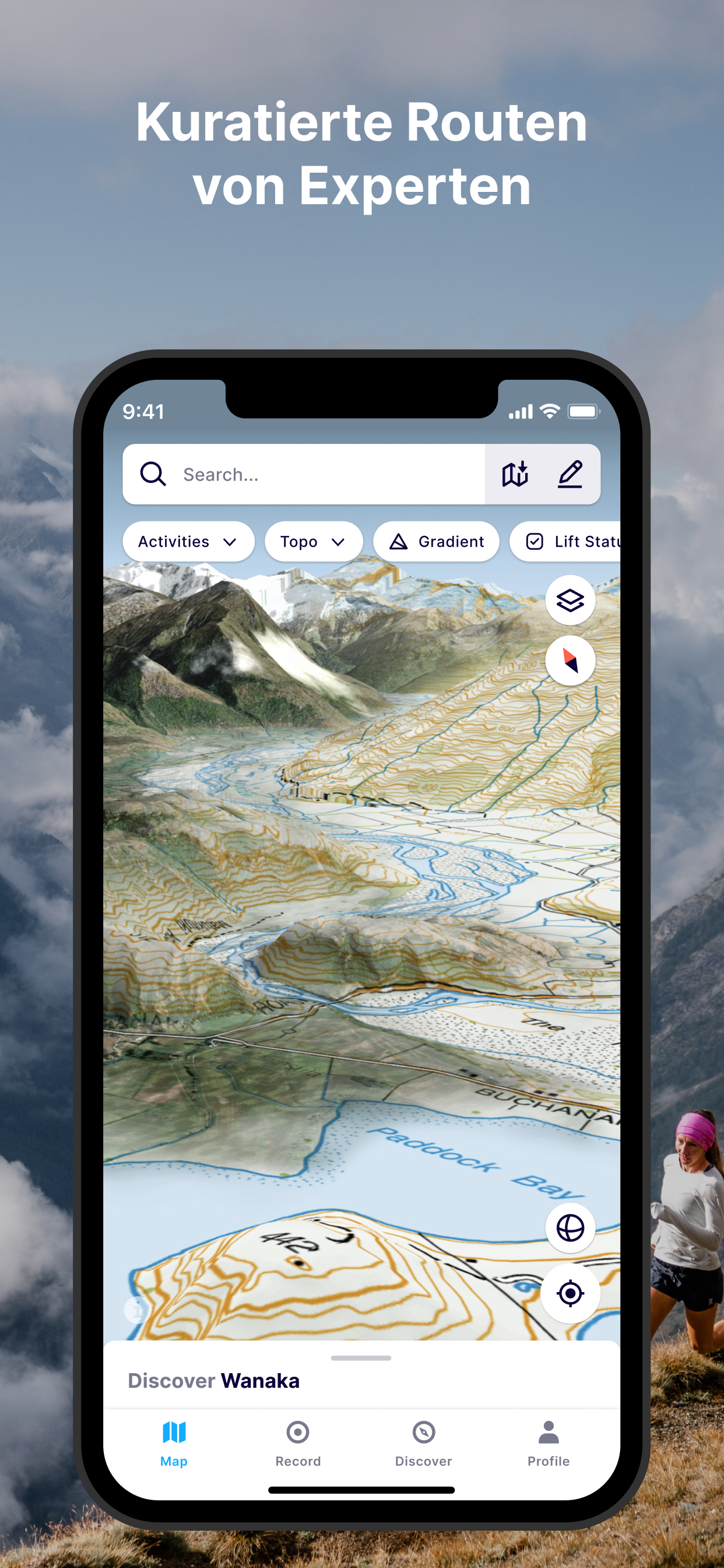
WELTWEITE OUTDOOR KARTE
- Erkunde Deine Region wie niemals zuvor. Die 3D Karte - speziell entwickelt für Outdoor Sport - mit intuitiven Kartenoverlays lässt Dich Deine nächste Route planen.
- Finde alle Wege: Wanderwege, Pfade, Singletracks und mehr
PLANE & NAVIGIERE
- Entdecke alle Details im Gebiet wie ein Einheimischer und plane Deine Route im Detail mit der fortschrittlichsten 3D-Outdoorkarte.
- Erstelle und teile Wegpunkte für die Planung mit Freunden zwecks einfacher Orientierung
ANALYSIERE DAS GELÄNDE
- Prüfe die Verhältnisse am Berg wie nie zuvor, um bessere Entscheidungen zu treffen. Dich unterstüzten dabei: Steigungsanischten, Höhenmeter, Lavinenkarten, flache Regionen, Sonneneinstrahlung und weitere Spezialansichten
ERLEBE DEINE ABENTEUER IN 3D
- Zeichne Dein Abenteuer in der App auf oder verbinde Suunto, Garmin or Strava und erlebe Deine Routen in 3D
- Teile atemberaubende Flyovers Deiner Abenteuer
DER NÄCHSTE SCHRITT: FATMAP EXPLORE
FATMAP Explore ist für alle, die mehr aus ihrem Outdoor-Erlebnis herausholen wollen.
TOPO-KARTEN
Offizielle Topo-Karten von swisstopo, USGS, IGN, basemap.it und mehr in 3D erleben.
LIVE SCHNEEBEDINGUNGEN
Prüfe die aktuelle Schneehöhe, den Neuschnee und die Schneevorhersage direkt auf der Karte.
LIVE LIFTE + PISTEN
Siehe in Echtzeit, welche Lifte und Pisten in der wachsenden Zahl verbundener Regionen geöffnet oder geschlossen sind
OFFLINE KARTEN
- Lade einen beliebigen Teil der Karte herunter und verwende sie ohne Internetverbindung.
- Schone Deine Batterie durch Verwendung der App im Flugzeugmodus
DIE BESTEN DEALS FÜR OUTDOOR AUSRÜSTUNG
- FATMAP Explore Mitglieder erhalten einzigartige Produkte oder tolle Discounts bei unseren Partnern: Mammut, Salomon, Suunto, Faction Ski und vielen mehr
FATMAP Explore setzt eine kostenpflichtige Mitgliedschaft voraus.
FEEDBACK ÜBER FATMAP
“FATMAP has changed the way I see and act in the mountains” - Xavier De Le Rue, The North Face Athlete
“Useful and inspiring (and also looks really really cool.)” - Forbes
"[FATMAP] may be the most ambitious adventure tech to hit the market since sat phones" - Outside Online
“An app that will revolutionise your backcountry freeriding experience” - Red Bull
Für technischen Support wende Dich bitte an:
[email protected]
FATMAP Explore ist als 12-monatiges Abonnement erhältlich. Du kannst dich über dein iTunes-Konto anmelden und bezahlen. Die Zahlung erfolgt über Dein iTunes-Konto bei Kaufbestätigung. Dein Abonnement verlängert sich automatisch, wenn es nicht mindestens 24 Stunden vor Ablauf des aktuellen Zeitraums gekündigt wird. Das Abonnement wird zu den gleichen Kosten verlängert. Du kannst Deine Abonnements verwalten und die automatische Verlängerung nach dem Kauf deaktivieren, indem Du in den Einstellungen auf die Seite ""Abonnement verwalten"" gehst. Jeder ungenutzte Teil einer kostenlosen Probezeit, falls angeboten, verfällt, wenn Du gegebenenfalls ein Abonnement erwirbst."
Allgemeine Geschäftsbedingungen: https://pages.fatmap.com/end-user-agreement/
Datenschutzerklärung: https://pages.fatmap.com/privacy-policy/