
FieldMap Pro
#1 Keyword Rankings
Today
Top 10 Rankings
Today
Top 30 Rankings
Today
Top 100 Rankings
Today
Description
FieldMap is a mobile mapping tool that enables you to bring your proprietary GIS (ArcMap, ArcGIS Pro, or GeoMedia) map into the field for use in offline or connected mode by field tech workers. Field tech workers can still work effectively where the wireless network is unreliable or non-existent. The dynamically rendered and labeled map increases situational awareness and provides access to custom, concise, sophisticated forms that integrate GIS-related info and external work-related asset management info for data collection.
FieldMap provides all the functionality needed in the field:
- Offline, vector, WYSIWYG display of your GIS map that has been published from your GIS and downloaded to your device.
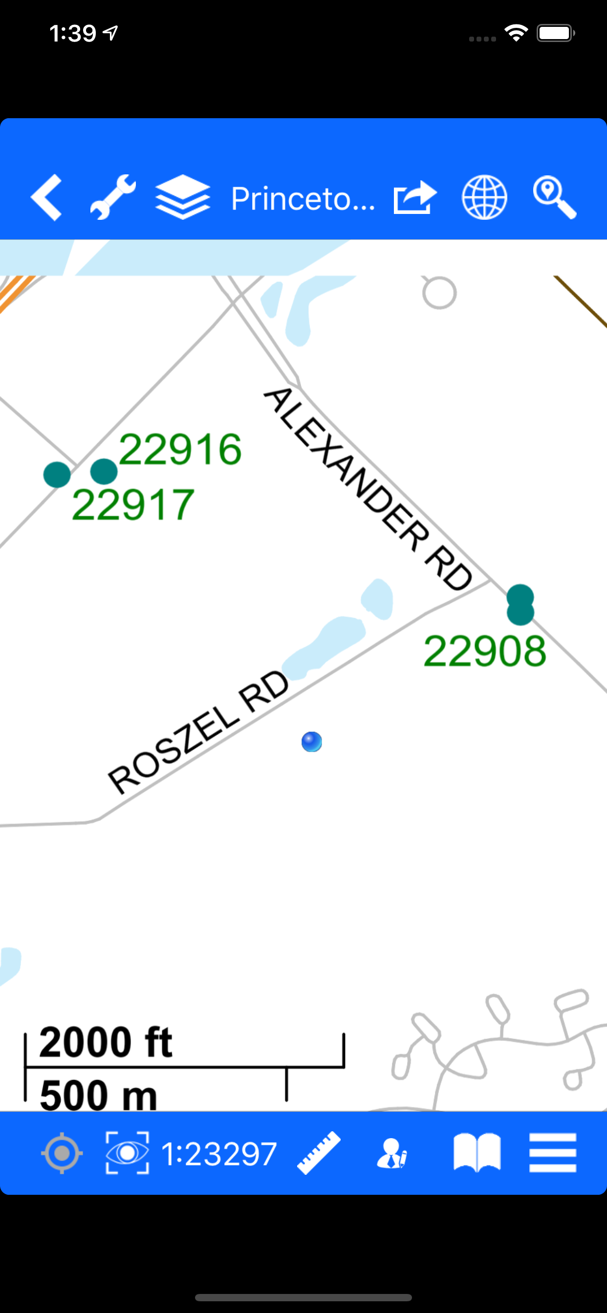
- Fully, dynamically labeled map according to your configuration in GIS for rapid map comprehension.
- Layer Control for turning layers on and off.
- Search for assets via attribute text or location-based augmented reality.
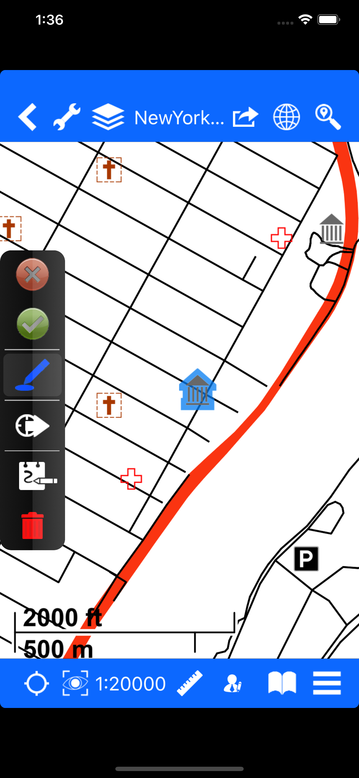
- Review asset attributes by tapping the asset on the map.
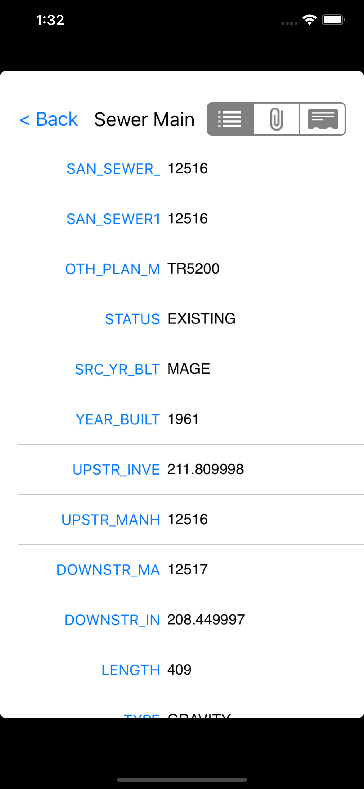
- Bring up a published asset form by tapping on the asset for easy data collection.
- Capture new assets in the field by tapping on the screen and/or using the on-board or external GPS receiver and also associate photos with the asset.
- Real time GPS location displayed on the map
- Distance and Area Measurement tools
- Overlay your GIS map on Apple Maps imagery or proprietary offline imagery (JP2 or ECW files).
- Mark-up map with redlines, share them with other FieldMap users, and email map image to back-office
- Download, display, and mark-up documents such as manuals, building plans, etc and share mark-up with other FieldMap users.
In the office, an organization can configure:
- User accounts for FieldMap users via a MapText web portal called FieldBox.
- Map publishing for use in the field
- Label placement rules with scale ranges
- Attributes for review in the field
- Search filters for the various layers
- Synchronization of field edits back into GIS
Hide..
Show more..
FieldMap provides all the functionality needed in the field:
- Offline, vector, WYSIWYG display of your GIS map that has been published from your GIS and downloaded to your device.
- Fully, dynamically labeled map according to your configuration in GIS for rapid map comprehension.
- Layer Control for turning layers on and off.
- Search for assets via attribute text or location-based augmented reality.
- Review asset attributes by tapping the asset on the map.
- Bring up a published asset form by tapping on the asset for easy data collection.
- Capture new assets in the field by tapping on the screen and/or using the on-board or external GPS receiver and also associate photos with the asset.
- Real time GPS location displayed on the map
- Distance and Area Measurement tools
- Overlay your GIS map on Apple Maps imagery or proprietary offline imagery (JP2 or ECW files).
- Mark-up map with redlines, share them with other FieldMap users, and email map image to back-office
- Download, display, and mark-up documents such as manuals, building plans, etc and share mark-up with other FieldMap users.
In the office, an organization can configure:
- User accounts for FieldMap users via a MapText web portal called FieldBox.
- Map publishing for use in the field
- Label placement rules with scale ranges
- Attributes for review in the field
- Search filters for the various layers
- Synchronization of field edits back into GIS
Screenshots


 User Rating
0 out of 5
0 ratings in Denmark
Ratings History
Reviews
App doesn't have any reviews yet
Store Rankings
Ranking History
App Ranking History not available yet
Category Rankings
|
Chart
|
Category
|
Rank
|
|---|---|---|
|
Top Free
|

|
458
|
Keywords
Users may also like
| Name | Reviews | Recent release | |
|---|---|---|---|

ArcGIS IPS Setup
ESRI
|
0
|
2 months ago | |

GIS Lite
Explore space
|
0
|
2 months ago | |
GIS4Mobile
Recording is rewarding
|
0
|
1 month ago | |

GIS Cloud Map Viewer
Maps and data in your pocket!
|
0
|
2 months ago | |

Mobile Data Collection
Collect using custom forms
|
0
|
3 months ago | |

SMASH Digital Field Mapping
Smart Mobile App for Surveyors
|
0
|
1 month ago | |

Unearth App
|
0
|
5 months ago | |

Touch GIS
Advanced field data collection
|
0
|
1 month ago | |

N/A/
N/A/
|
0
|
6 days ago | |

Mapboard GIS
Draw your field maps into GIS
|
0
|
4 weeks ago |
Show More
Revenue and Downloads
Gain valuable insights into FieldMap Pro performance with our analytics. Sign up now
to
access downloads, revenue, and more.
App Info
- Category
- Productivity
- Publisher
- Maptext, Inc.
- Languages
- English
- Recent version
- 1.5.29 (1 month ago )
- Released on
- Aug 12, 2014 (9 years ago )
- Also available in
- United States, Pakistan, Italy, Japan, South Korea, Kuwait, Kazakhstan, Lebanon, Mexico, Malaysia, Nigeria, Netherlands, Norway, New Zealand, Peru, Philippines, India, Poland, Portugal, Romania, Russia, Saudi Arabia, Sweden, Singapore, Thailand, Turkey, Taiwan, Ukraine, Vietnam, South Africa, Denmark, Argentina, Austria, Australia, Azerbaijan, Belgium, Brazil, Belarus, Canada, Switzerland, Chile, China, Colombia, Czechia, Germany, United Arab Emirates, Dominican Republic, Algeria, Ecuador, Egypt, Spain, Finland, France, United Kingdom, Greece, Hong Kong, Hungary, Indonesia, Ireland, Israel
- Last updated
- 1 month ago