
Fish Fathom: Fishing & Boating
Fishing and Navigation Maps
#1 Keyword Rankings
Today
Top 10 Rankings
Today
Top 30 Rankings
Today
Top 100 Rankings
Today
Description
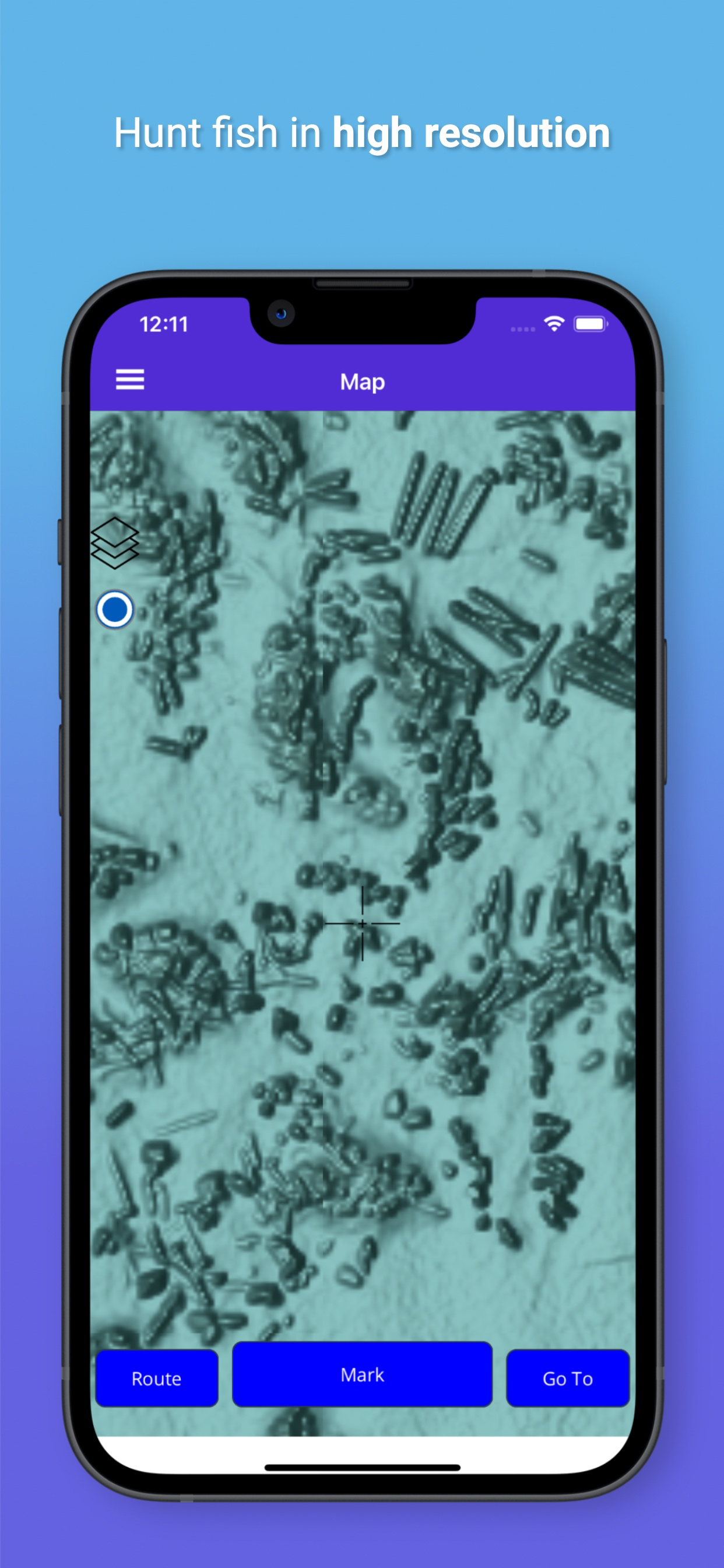
Upgrade to High-Res Navigation & Relief Shading Fishing Charts! Say goodbye to pixelation and guesswork; see the bottom clearly and reel in more fish
Marine Navigation with Waypoints, Routes, and High Resolution Bathymetry Relief Shading
Embark on your coastal adventures with Fish Fathom, the ultimate companion for enthusiasts of marine activities like boating, fishing, and diving. Navigate the seas with confidence using our intuitive app, equipped with high resolution maps that reveal intricate bottom structures with unprecedented detail uncovering hidden underwater fishing spots including rock piles, ledges, reefs, wrecks and other hard to see obstructions. Craft personalized routes and waypoints effortlessly from the comfort of your couch, ensuring your fishing journey is tailored to the targeted species for the day.
Whether you're charting a course for your next fishing expedition or seeking the perfect dive spot, Fish Fathom is your trusted guide to the wonders of coastal waters. Download now and elevate your fishing game!
Features -
- Offline NOAA ENC Navigational Charts & Relief Shading
- High Resolution Bathymetry Relief Shading map layer allows you to see more details of bottom structure such as ledges, reefs, rock piles, and wrecks so you can find and catch more fish.
- High Resolution Navigation Chart map layer provides granular depth information and detailed map features like public reefs, wrecks, channels, marker buoys and other marine points of interest
- Create and Manage Unlimited Routes and Waypoints
- Navigate to Waypoints and Routes using Course Up or North up while monitoring your speed and distance until destination
- Waypoint Formats include both DMS (Degrees Minutes Seconds) and DD (Decimal Degrees) so you can transfer between the app and your chart plotter.
- Track distance from destination in your preference of Miles, Nautical Miles, or Kilometers
Supported locations include the following coastal areas
- Continental United States & Great Lakes
- Canada (North West)
- Mexico (North West & Caribbean)
- Bahamas
Terms of Use (EULA) - https://www.apple.com/legal/internet-services/itunes/dev/stdeula/
Hide..
Show more..
Marine Navigation with Waypoints, Routes, and High Resolution Bathymetry Relief Shading
Embark on your coastal adventures with Fish Fathom, the ultimate companion for enthusiasts of marine activities like boating, fishing, and diving. Navigate the seas with confidence using our intuitive app, equipped with high resolution maps that reveal intricate bottom structures with unprecedented detail uncovering hidden underwater fishing spots including rock piles, ledges, reefs, wrecks and other hard to see obstructions. Craft personalized routes and waypoints effortlessly from the comfort of your couch, ensuring your fishing journey is tailored to the targeted species for the day.
Whether you're charting a course for your next fishing expedition or seeking the perfect dive spot, Fish Fathom is your trusted guide to the wonders of coastal waters. Download now and elevate your fishing game!
Features -
- Offline NOAA ENC Navigational Charts & Relief Shading
- High Resolution Bathymetry Relief Shading map layer allows you to see more details of bottom structure such as ledges, reefs, rock piles, and wrecks so you can find and catch more fish.
- High Resolution Navigation Chart map layer provides granular depth information and detailed map features like public reefs, wrecks, channels, marker buoys and other marine points of interest
- Create and Manage Unlimited Routes and Waypoints
- Navigate to Waypoints and Routes using Course Up or North up while monitoring your speed and distance until destination
- Waypoint Formats include both DMS (Degrees Minutes Seconds) and DD (Decimal Degrees) so you can transfer between the app and your chart plotter.
- Track distance from destination in your preference of Miles, Nautical Miles, or Kilometers
Supported locations include the following coastal areas
- Continental United States & Great Lakes
- Canada (North West)
- Mexico (North West & Caribbean)
- Bahamas
Terms of Use (EULA) - https://www.apple.com/legal/internet-services/itunes/dev/stdeula/
In-Apps
- Hi Resolution Map Layers
- $2.99
- High Resolution Map Layers
- $2.99
Screenshots


 User Rating
1 out of 5
0 ratings in United States
Ratings History
Reviews
App doesn't have any reviews yet
Store Rankings
Ranking History
App Ranking History not available yet
Category Rankings
App is not ranked yet
Keywords
Users may also like
| Name | Reviews | Recent release | |
|---|---|---|---|

SEAiq USA
|
20
|
1 week ago | |

Bridge Schedule
Daily Bridge Closure Info.
|
4
|
2 years ago | |

Fishing Status PRO
Local Fishing Data and Spots
|
1
|
1 month ago | |

Hip Charts
NOAA ENC Charts
|
1
|
1 year ago | |

RT-Nav
|
4
|
1 year ago | |

Sea Pro Connect
|
0
|
1 year ago | |

DistanceSurvey
|
1
|
1 year ago | |

Fish Mapping
SiriusXM Fish Mapping
|
1
|
3 weeks ago | |

N/A/
N/A/
|
0
|
2 years ago | |

Ditch: Boating Navigation
Marine GPS, Boat Charts, Maps
|
9
|
1 week ago |
Show More
Revenue and Downloads
Gain valuable insights into Fish Fathom: Fishing & Boating performance with our analytics. Sign up now
to
access downloads, revenue, and more.
App Info
- Category
- Navigation
- Publisher
- BOATGLIDER, LLC
- Languages
- Recent version
- 2.2.2 (1 month ago )
- Released on
- Feb 14, 2024 (5 months ago )
- Also available in
- United States
- Last updated
- 1 month ago