Description
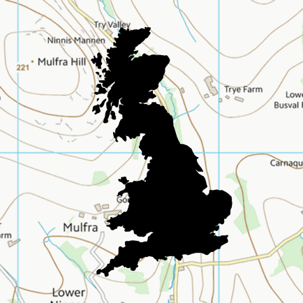
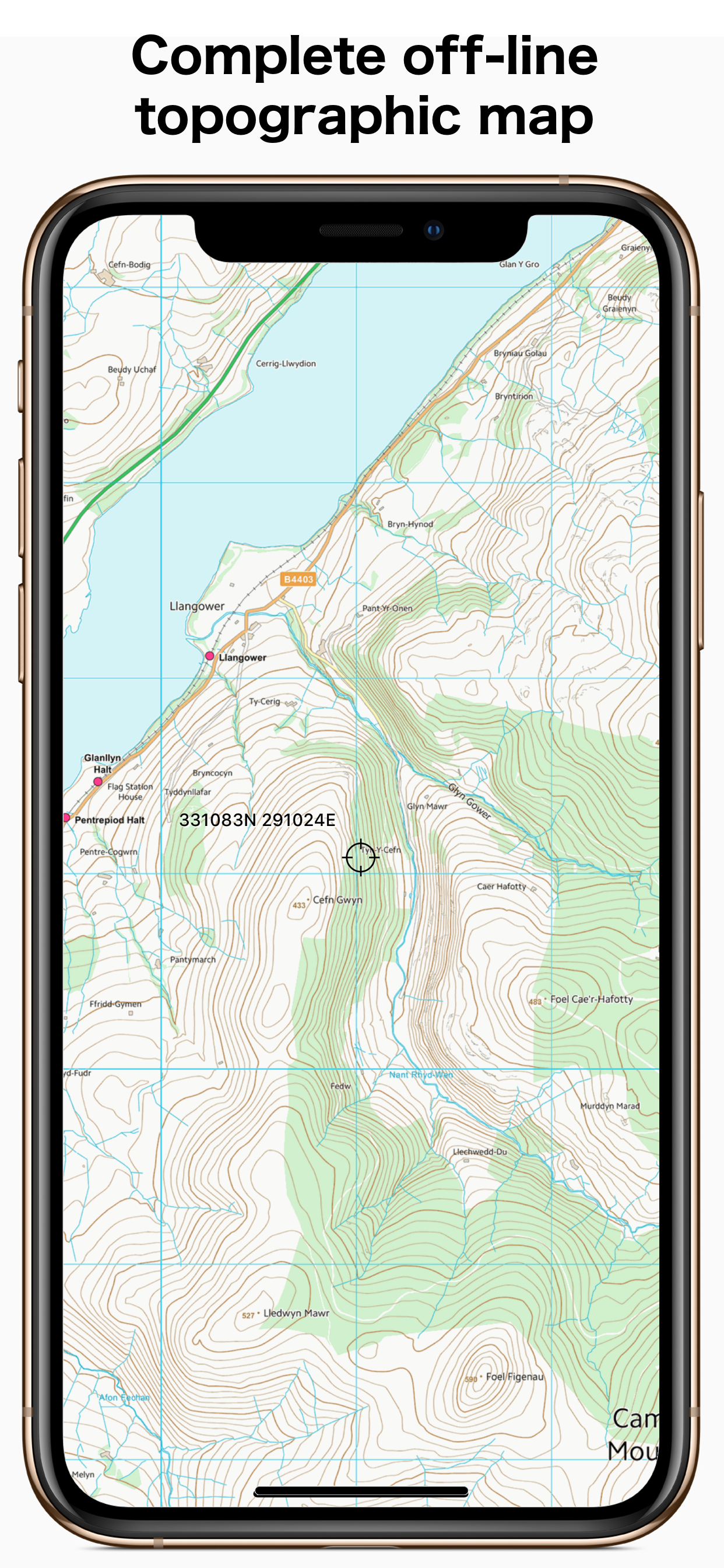
This app gives 100% offline topographic map coverage of Great Britain installed directly with the app. No further downloads required, no account signups, no ongoing subscriptions, just seamless pan and zoom across the whole country at an effective resolution of about 1:25k. Perfect for outdoor use, walking, running, hunting, fishing, cycling, particularly in remote areas with poor cellphone coverage.
Please note that this is a large app (4GB) and you will need to have sufficient space to install it.
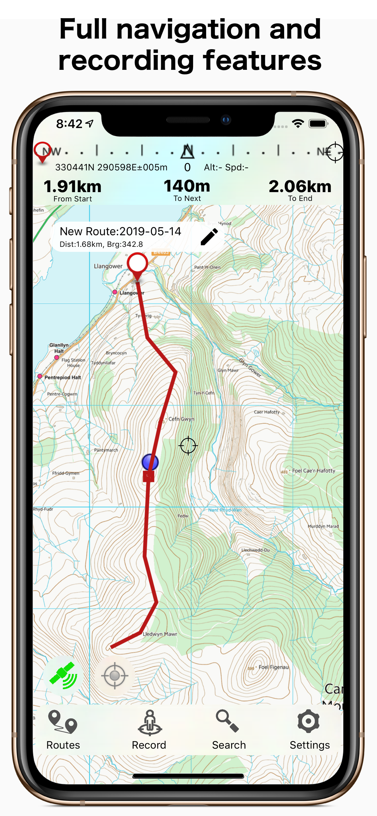
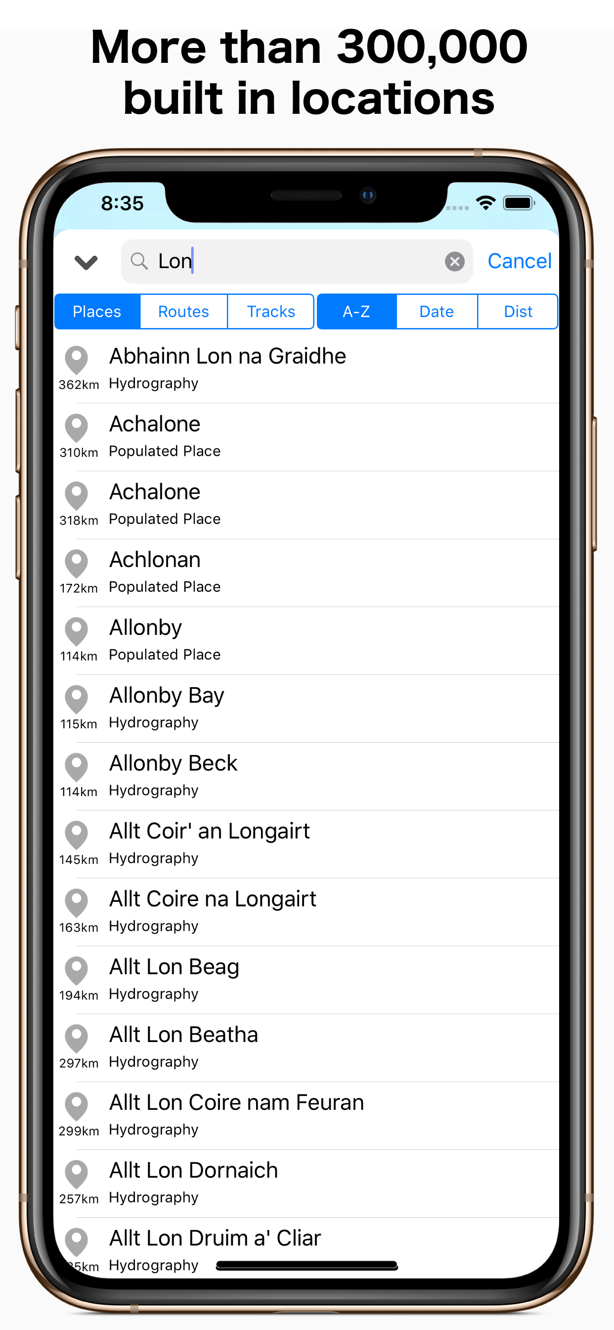
GBTopoMap includes full navigation functions including route planning, track recording, navigation to points or following routes, over 300,000 built in locations and landmarks. Directly import or share files from any source or channel of your choice. Maps are based on Ordnance Surveys VectorMap District and terrain data that gives 10 m contour intervals, combined with OpenStreetMap data on public access ways. The maps are fully installed on your device when you download and install the app from the App Store. Maps will update periodically after that using standard app version updates through the App Store.
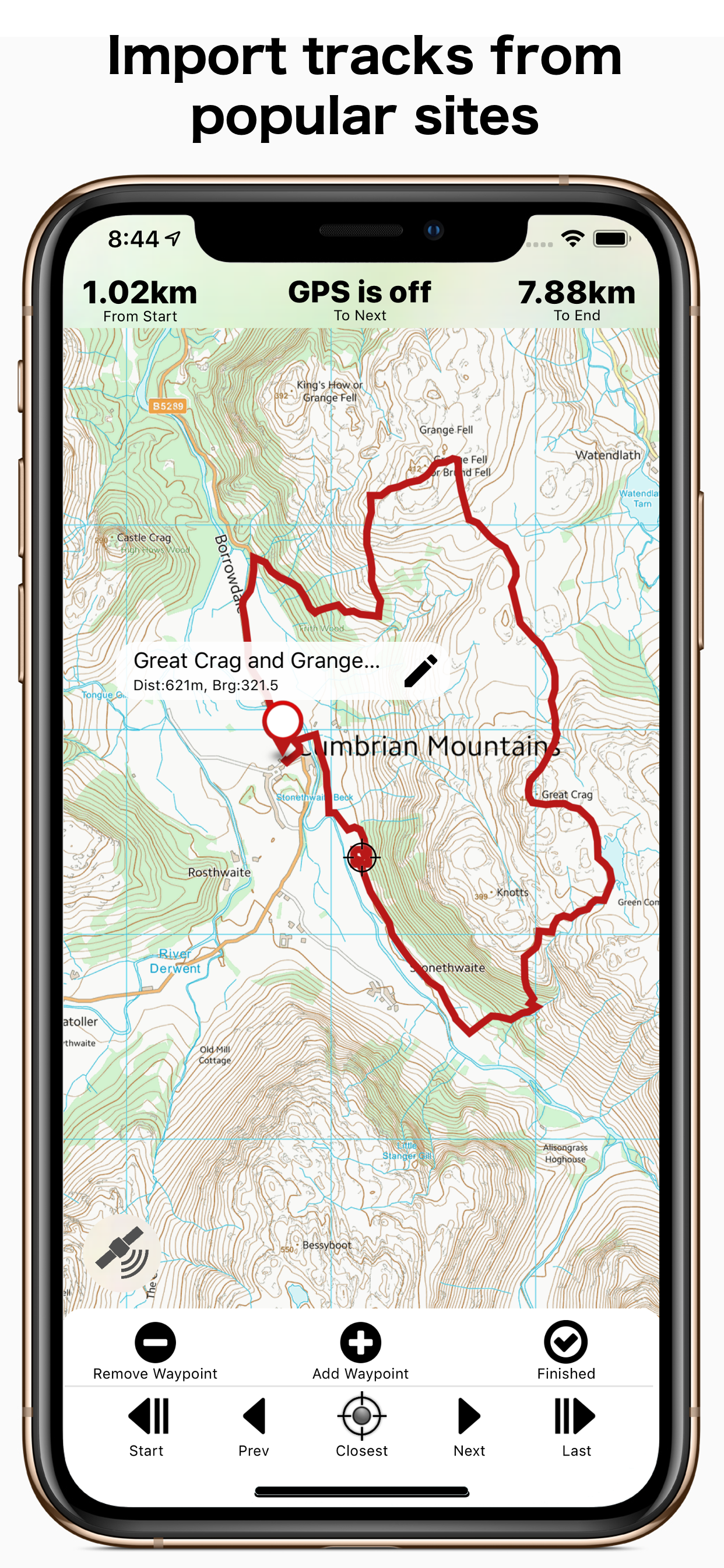
Works well with popular British sites describing local walks and activities. Click on .gpx or .kml track links to import directly into the app.
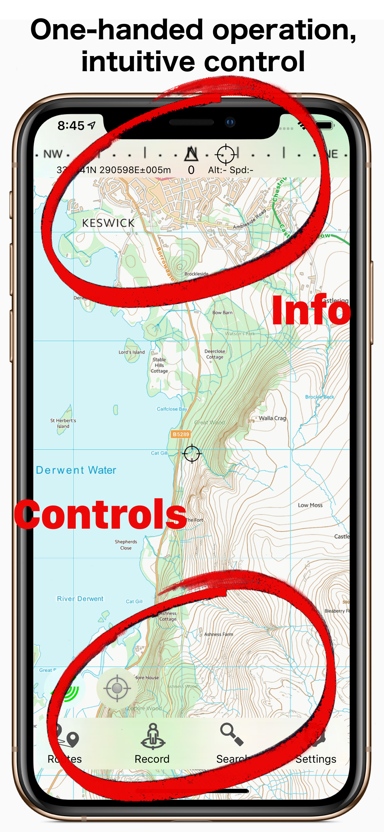
The app is build from the ground up to use the true British National Grid, not the commonly used WGS84 global approximation which doesn't give a true uniform grid. We also design from the ground up for functionality. Controls are at the bottom of the screen where you can operate them one handed without shifting your grip, and information is biased towards the top of the screen. All functionality can be accessed with a single tap from the main screen, so that there are no nested layers of menus that you have to navigate or memorise to find what you are after.
The app is completely stand-alone and doesn't require account logins or requests for contact information, feedback, or ratings. We are delighted to hear from anyone with a question or suggestion, and you can check out some of our online info and guides, but you won't hear from us otherwise.
Please note that, as with any GPS navigational app, use of GPS positioning will place a higher demand on your battery and continuous use of GPS will discharge the battery at a faster rate. The GBTopoMap app gives you full control over this. GPS positioning is only activated when actually needed and can be switched on or off at the tap of a button.
Tip of the day: For navigating using the compass functions, look up how to do the 'figure of 8' wave to trigger internal calibration of the compass. Easy to do and makes for reliable and accurate compass readings.
Hide
Show More...
Please note that this is a large app (4GB) and you will need to have sufficient space to install it.
GBTopoMap includes full navigation functions including route planning, track recording, navigation to points or following routes, over 300,000 built in locations and landmarks. Directly import or share files from any source or channel of your choice. Maps are based on Ordnance Surveys VectorMap District and terrain data that gives 10 m contour intervals, combined with OpenStreetMap data on public access ways. The maps are fully installed on your device when you download and install the app from the App Store. Maps will update periodically after that using standard app version updates through the App Store.
Works well with popular British sites describing local walks and activities. Click on .gpx or .kml track links to import directly into the app.
The app is build from the ground up to use the true British National Grid, not the commonly used WGS84 global approximation which doesn't give a true uniform grid. We also design from the ground up for functionality. Controls are at the bottom of the screen where you can operate them one handed without shifting your grip, and information is biased towards the top of the screen. All functionality can be accessed with a single tap from the main screen, so that there are no nested layers of menus that you have to navigate or memorise to find what you are after.
The app is completely stand-alone and doesn't require account logins or requests for contact information, feedback, or ratings. We are delighted to hear from anyone with a question or suggestion, and you can check out some of our online info and guides, but you won't hear from us otherwise.
Please note that, as with any GPS navigational app, use of GPS positioning will place a higher demand on your battery and continuous use of GPS will discharge the battery at a faster rate. The GBTopoMap app gives you full control over this. GPS positioning is only activated when actually needed and can be switched on or off at the tap of a button.
Tip of the day: For navigating using the compass functions, look up how to do the 'figure of 8' wave to trigger internal calibration of the compass. Easy to do and makes for reliable and accurate compass readings.
Screenshots


GBTopoMap FAQ
-
Is GBTopoMap free?
Yes, GBTopoMap is completely free and it doesn't have any in-app purchases or subscriptions.
-
Is GBTopoMap legit?
Not enough reviews to make a reliable assessment. The app needs more user feedback.
Thanks for the vote -
How much does GBTopoMap cost?
GBTopoMap is free.
-
What is GBTopoMap revenue?
To get estimated revenue of GBTopoMap app and other AppStore insights you can sign up to AppTail Mobile Analytics Platform.

User Rating
App is not rated in India yet.
Ratings History
GBTopoMap Reviews
Store Rankings
Ranking History
App Ranking History not available yet
Category Rankings
|
Chart
|
Category
|
Rank
|
|---|---|---|
|
Top Paid
|

|
100
|
|
Top Paid
|

|
191
|
|
Top Paid
|

|
224
|
|
Top Paid
|

|
233
|
|
Top Paid
|

|
235
|
GBTopoMap Competitors
| Name | Downloads (30d) | Monthly Revenue | Reviews | Ratings | Recent release | |
|---|---|---|---|---|---|---|

Lomond and South Scotland Map
National Park Topo Map
|
View
|
View
|
0
|
|
3 years ago | |

Ben Nevis, West Scotland Map
|
View
|
View
|
0
|
|
3 years ago | |

QuestNative Scotland
Play in Edinburgh & Scotland!
|
View
|
View
|
0
|
|
3 years ago | |

York’s Best: UK Travel Guide
|
View
|
View
|
0
|
|
1 year ago | |

The Cairngorms Outdoor Map
|
View
|
View
|
0
|
|
3 years ago | |
Kinghorn Heritage Trail
Learn about Kinghorn in Fife
|
View
|
View
|
0
|
|
2 years ago | |
Northumberland Map
|
View
|
View
|
0
|
|
3 years ago | |

iStreams Orkney Islands
|
View
|
View
|
0
|
|
4 months ago | |

Ben Nevis, W Scotland Map Pro
Outdoor Topo Map
|
View
|
View
|
0
|
|
3 years ago | |

Pentlands Outdoor Map
Offline outdoor map
|
View
|
View
|
0
|
|
3 years ago |
GBTopoMap Installs
Last 30 days
GBTopoMap Revenue
Last 30 daysGBTopoMap Revenue and Downloads
Gain valuable insights into GBTopoMap performance with our analytics.
Sign up now to access downloads, revenue, and more.
Sign up now to access downloads, revenue, and more.
App Info
- Category
- Navigation
- Publisher
-
Right Place Resources
- Languages
- English
- Recent release
- 1.1 (5 years ago )
- Released on
- May 17, 2019 (5 years ago )
- Also available in
- United States, United Kingdom, Switzerland, Nepal, Peru, Norway, Netherlands, Nigeria, Malaysia, Mexico, Madagascar, Lebanon, Kazakhstan, Kuwait, South Korea, Japan, Italy, Iceland, India, New Zealand, Israel, Philippines, Pakistan, Portugal, Romania, Russia, Saudi Arabia, Sweden, Singapore, Thailand, Türkiye, Ukraine, Uzbekistan, Vietnam, South Africa, Colombia, Armenia, Argentina, Austria, Australia, Azerbaijan, Belgium, Bulgaria, Bahrain, Brunei, Brazil, Belarus, Canada, Chile, China, Czechia, Finland, Ireland, Indonesia, Hungary, Croatia, Greece, France, Germany, Spain, Egypt, Ecuador, Algeria, Dominican Republic, Denmark, Taiwan, Hong Kong SAR China, Poland, United Arab Emirates
- Last Updated
- 1 week ago
This page includes copyrighted content from third parties, shared solely for commentary and research in accordance with fair use under applicable copyright laws. All trademarks, including product, service, and company names or logos, remain the property of their respective owners. Their use here falls under nominative fair use as outlined by trademark laws and does not suggest any affiliation with or endorsement by the trademark holders.