Muito Bom
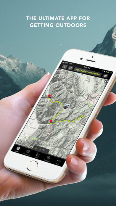
Só não dou 5 * porque o mapa não roda para indicar a direcção do percurso...
GPS Kit is not free (it costs 9.99), however it doesn't contain in-app purchases or subscriptions.
🤔 The GPS Kit app's quality is mixed. Some users are satisfied, while others report issues. Consider reading individual reviews for more context.
The price of GPS Kit is 9.99.
To get estimated revenue of GPS Kit app and other AppStore insights you can sign up to AppTail Mobile Analytics Platform.

4.38 out of 5
8 ratings in Portugal
Só não dou 5 * porque o mapa não roda para indicar a direcção do percurso...
Map should rotate for better navigation, will give 5 stars when have that, anyway it's a good app.
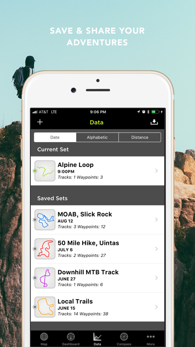
It does replace a standard dedicated gps. I am using it for offroading and it is fantastic. Good features: great integration with google earth (kmz). Great offline navigation. Very easy to use. Nice to have different paths visible or hidden. Includes maps of the entire world free of charge. Only minor suggestions: 1) better way of downloading offline maps. It is not very pratical. It would be great to overlap your route with offline map downloading feature. Overall it saved me 200euros because I did not need buy a garmin device. Great app!!!
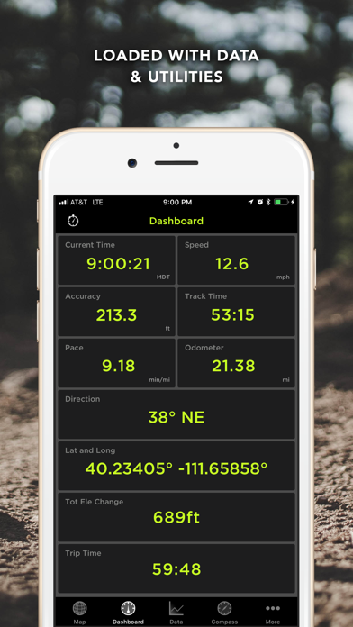
It's an interesting application but needs some improvements. The (it seams to me) SIRF Altitude correction is missing, whish makes the altitude information useless. As an example, my Garmin 60CSx shows 90 m at my place, the same as my HTC p3600 when in Oziexplorer CE with SIRF Altitude correction. When the HTC is not using the correction it shows the same altitude as the iphone with GPS kit, i.e. 145 m. It will be nice to have information of the satellite constellation, like in a "real" GPS or in Oziexplorer CE. Also a unic dashboard field with Latitude and Longitude (together) and of course UTM Coordinates in WGS84 (for starting) would be nice.
Very nice application. I am loving it. It only takes 4 stars because there is a small bug on Dashboard. If we select the Directon (and Bearing) window there is wrong indication on Bearing. Example: - if we are heading northwest the direction indicator shows NW (which is correct) but the bearing shows 135 degrees (which is wrong) - if we are heading southeast it shows SE/315 degrees - if we are heading south it shows S/270 - if we are heading east it shows E/360 - etc
I’ve been using GPS kit for few years now, this week it started to crash when I try to export saved tracks, I hope the developer could fix this Thanks
Company is gone. Web site is gone. Hasn’t been updated in 6 years. Don’t spend your money on this!
After I update my iOS version,this app is not working,after open it the app will be crashing. I can’t use this app and my tracking will not be able to access
Experiencing a significant issue with gpskit on iOS 17 – unfortunately, the application owner seems to have discontinued support. Save your money for now. The app fails to import or record tracks, and attempts to contact support via email have gone unanswered. If you’re on an older iOS version, it performs flawlessly. Hoping for an update or resolution soon.
Please update the APP … its not fit in new iphone screens …also update icons please …
|
Chart
|
Category
|
Rank
|
|---|---|---|
|
Top Paid
|

|
2
|
|
Top Paid
|

|
4
|
|
Top Paid
|

|
5
|
|
Top Paid
|

|
5
|
|
Top Paid
|

|
6
|
| Name | Downloads (30d) | Monthly Revenue | Reviews | Ratings | Recent release | |
|---|---|---|---|---|---|---|

Theodolite
AR Navigation Viewfinder
|
Unlock
|
Unlock
|
1
|
|
1 year ago | |
Maps 3D PRO - Outdoor GPS
GPS for Bike, Hike & Ski
|
Unlock
|
Unlock
|
7
|
|
7 months ago | |

Tactical NAV
Precision MGRS Navigation
|
Unlock
|
Unlock
|
0
|
|
1 month ago | |

GPS Tracks
GPS Tracker and Offline Maps
|
Unlock
|
Unlock
|
3
|
|
1 week ago | |

Map Plus
A Powerful Map and GIS tool
|
Unlock
|
Unlock
|
6
|
|
8 months ago | |

4WD Maps - Offline Topo Maps
Offroad 4x4 GPS Navigation
|
Unlock
|
Unlock
|
0
|
|
2 years ago | |

BackCountry Navigator XE
Topo Maps and GPS for Outdoors
|
Unlock
|
Unlock
|
0
|
|
3 weeks ago | |

GPX Viewer PRO
Trilhas e pontos de referência
|
Unlock
|
Unlock
|
1
|
2
|
3 months ago | |

Military GPS Survival Kit
MGRS SAR Tactical Navigation
|
Unlock
|
Unlock
|
0
|
|
2 weeks ago | |

Global Mapper Mobile
|
Unlock
|
Unlock
|
0
|
|
1 month ago |
