
Description
Download the app for a 30-day free trial by signing in with your Apple ID. You can then request a full trial version via email.
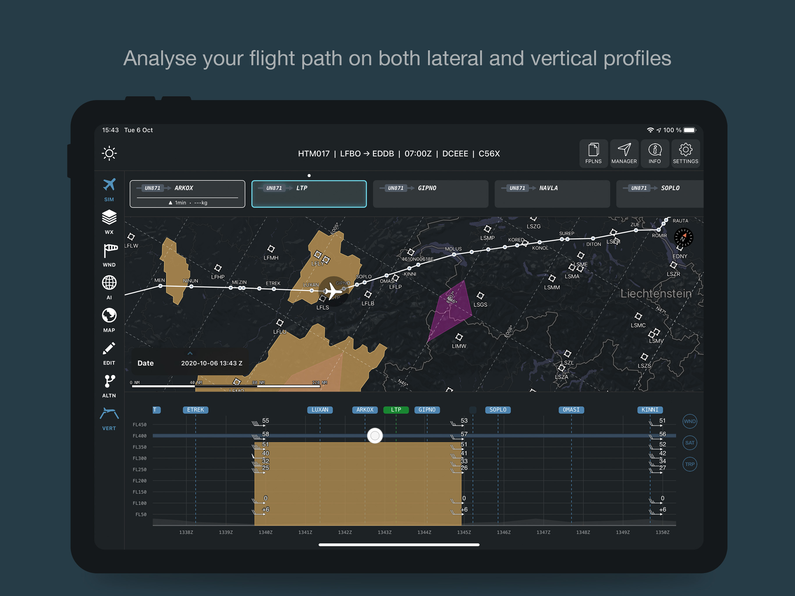
Guidor offers an intuitive and detailed representation of a flight path and the whole environment surrounding it. E.g. lateral and vertical profile, surrounding waypoints and airports, surrounding weather phenomenons etc...
It merges and aggregates several databases and report systems in order to display the most precise and relevant information (weather, Taf/Metar, ADS-B)...
Guidor uses certified file format and protocols (ARINC), so that it can easily communicate with avionics for instance and get even more precise computations.
It also offers powerful tools to optimise trajectories and save up flight time, fuel and money (vertical optimisation, lateral re-routing, real-time update of the estimated fuel consumption and estimated time of arrival, notification and alerts of upcoming turbulences or airport status).
Hide
Show More...
Guidor offers an intuitive and detailed representation of a flight path and the whole environment surrounding it. E.g. lateral and vertical profile, surrounding waypoints and airports, surrounding weather phenomenons etc...
It merges and aggregates several databases and report systems in order to display the most precise and relevant information (weather, Taf/Metar, ADS-B)...
Guidor uses certified file format and protocols (ARINC), so that it can easily communicate with avionics for instance and get even more precise computations.
It also offers powerful tools to optimise trajectories and save up flight time, fuel and money (vertical optimisation, lateral re-routing, real-time update of the estimated fuel consumption and estimated time of arrival, notification and alerts of upcoming turbulences or airport status).
Screenshots


Guidor Skyconseil FAQ
-
Is Guidor Skyconseil free?
Yes, Guidor Skyconseil is completely free and it doesn't have any in-app purchases or subscriptions.
-
Is Guidor Skyconseil legit?
Not enough reviews to make a reliable assessment. The app needs more user feedback.
Thanks for the vote -
How much does Guidor Skyconseil cost?
Guidor Skyconseil is free.
-
What is Guidor Skyconseil revenue?
To get estimated revenue of Guidor Skyconseil app and other AppStore insights you can sign up to AppTail Mobile Analytics Platform.

User Rating
App is not rated in Japan yet.
Ratings History
Guidor Skyconseil Reviews
Store Rankings
Ranking History
App Ranking History not available yet
Category Rankings
App is not ranked yet
Guidor Skyconseil Competitors
| Name | Downloads (30d) | Monthly Revenue | Reviews | Ratings | Recent release | |
|---|---|---|---|---|---|---|

AeroPlus Aviation Weather
N/A
|
Unlock
|
Unlock
|
0
|
|
3 months ago | |

RocketRoute FlightPlan
|
Unlock
|
Unlock
|
0
|
|
2 weeks ago | |

AeroWeather Pro
Current and precise weather
|
Unlock
|
Unlock
|
13
|
|
16 hours ago | |

ATIS App
Digital ATIS for US Airports!
|
Unlock
|
Unlock
|
0
|
|
3 months ago | |

Radair4D
Synthetic 4D Weather Radar
|
Unlock
|
Unlock
|
0
|
|
2 years ago | |

MentalCrosswind
|
Unlock
|
Unlock
|
0
|
|
2 years ago | |

WSI Pilotbrief Optima
|
Unlock
|
Unlock
|
0
|
|
2 weeks ago | |

SITA eWAS
|
Unlock
|
Unlock
|
0
|
|
1 week ago | |

SmartBriefing METAR,TAF,NOTAMS
Best Weather App for Pilots
|
Unlock
|
Unlock
|
0
|
|
1 year ago | |

AirportWeather.com
Weather for every airport
|
Unlock
|
Unlock
|
0
|
|
1 year ago |
Guidor Skyconseil Installs
Last 30 days
Guidor Skyconseil Revenue
Last 30 daysGuidor Skyconseil Revenue and Downloads
Gain valuable insights into Guidor Skyconseil performance with our analytics.
Sign up now to access downloads, revenue, and more.
Sign up now to access downloads, revenue, and more.
App Info
- Category
- Weather
- Publisher
-
SKYCONSEIL

- Languages
- English
- Recent release
- 1.64.5 (2 weeks ago )
- Released on
- Oct 24, 2020 (4 years ago )
- Also available in
- United Kingdom , France , Poland , South Korea , Kuwait , Kazakhstan , Lebanon , Mexico , Malaysia , Nigeria , Norway , New Zealand , Peru , Philippines , Pakistan , India , Portugal , Romania , Russia , Saudi Arabia , Sweden , Singapore , Thailand , Türkiye , Taiwan , Ukraine , United States , Vietnam , South Africa , Germany , Argentina , Austria , Australia , Azerbaijan , Belgium , Brazil , Belarus , Canada , Switzerland , Chile , China , Colombia , Czechia , Japan , Denmark , Dominican Republic , Algeria , Ecuador , Egypt , Finland , Greece , Hong Kong SAR China , Indonesia , Ireland , Israel , United Arab Emirates
- Last Updated
- 6 days ago
This page includes copyrighted content from third parties, shared solely for commentary and research in accordance with fair use under applicable copyright laws. All trademarks, including product, service, and company names or logos, remain the property of their respective owners. Their use here falls under nominative fair use as outlined by trademark laws and does not suggest any affiliation with or endorsement by the trademark holders.