
Hawaiian Islands Looksee AR
Explore with Augmented Reality
#1 Keyword Rankings
Today
Top 10 Rankings
Today
Top 30 Rankings
Today
Top 100 Rankings
Today
Description
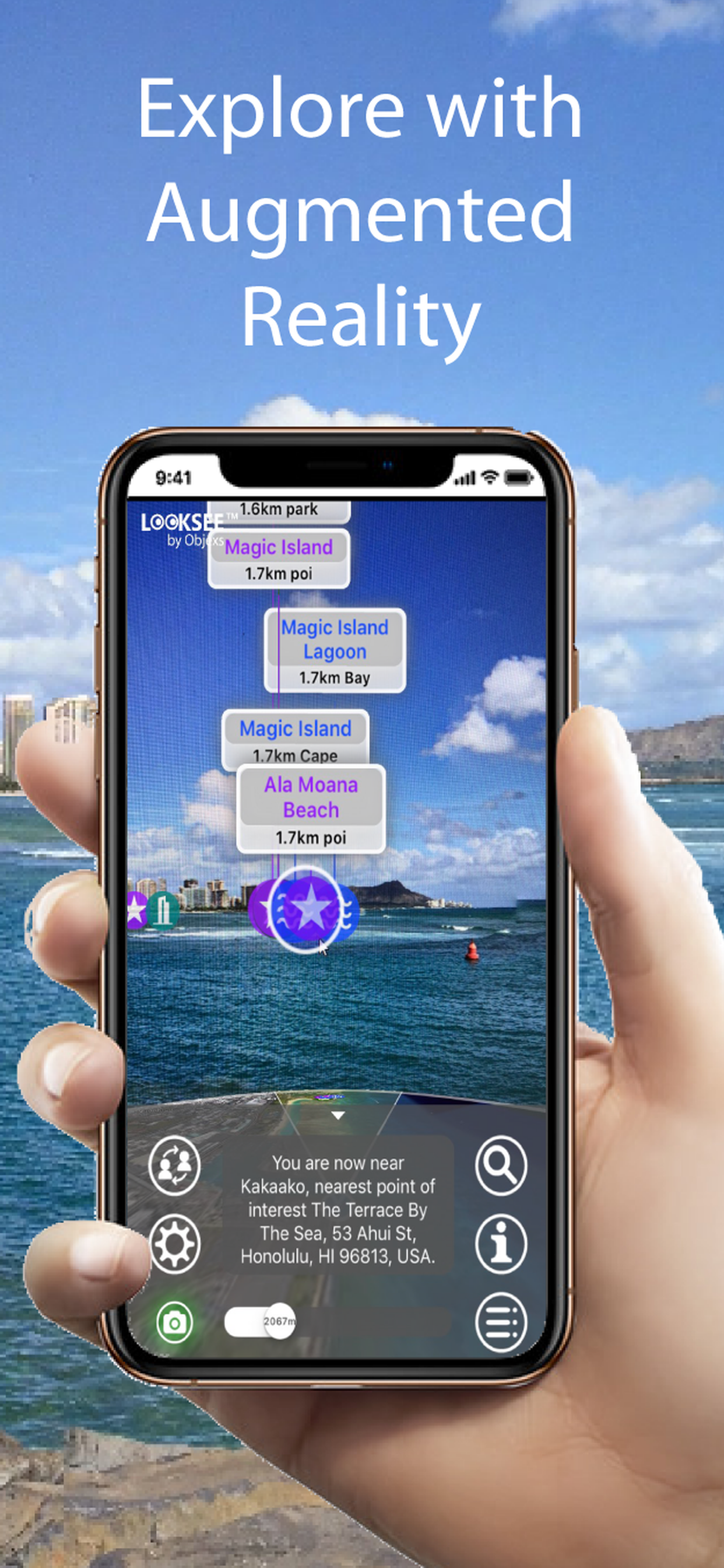
Looksee AR for the Hawaiian Island, USA, is an Augmented Reality (AR) viewer used to find places of interest from close up to 10km away directly within your phone's camera view and add fun, knowledge and interest to your adventures and tours.
Ideal for both tourists and locals wishing to explore and find out more about their surroundings and beyond: whether by foot, bicycle,car, taxi or Uber!
It's simple to use - you just point and go! It includes a choice of Map or Satellite Image in view and a Search function to help locate things.
Once downloaded no wi-fi or cellular network is necessary, so you can use when out and about in the Hawaiian Islands, even when there is no or poor signal coverage.
This version, for the Hawaiian Islands, locates places on all islands including Hawaii, Niihau, Kauai, Oahu, Maui, Molokai, Lanai and Kahoolawe. In fact the area covered encompasses a rectangle stretching north-west from Nihau and Kanai to south-east at Hawaii. This is an area of over 80,000 sq miles (200,000 km2).
All towns and districts within the region are covered including: Hana, Hilo, Honolulu, Lihue and Waimea.
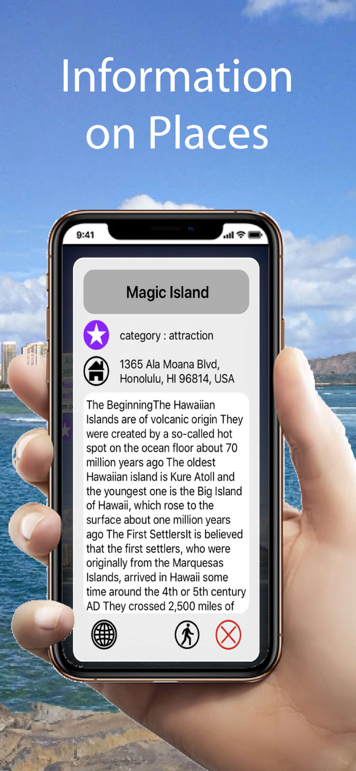
In fact there are around 10,000 places of interest viewable within the App including Mono Loa, Mona Kea, the Waipio park, Waikiki, Hapuna Beach and Rainbow Falls.
Categories that can be viewed and selected include Tourist Attractions, Hills, Lakes, Parks & Woodlands, Cities, Towns, Suburban Areas, Villages & Hamlets, Cafes, Restaurants, Cafes, Airports, Train & Major Bus Stations, Municipal Buildings, Places of Worship, Historic Sites and Museums & Arts.
Some of the helpful Looksee features include:
- Interactive objects (that you can touch for more information on them)
- Magic EYE (to declutter the visuals and select only objects within)
- Satellite or Map image in view (can select which or disable completely)
- Search menu (with on-screen directional arrow and indicator graphics)
- Filters menu (using which the categories of points of interest you wish to display can be easily filtered out or selected)
- Distance slider (for an interactive depth of view filter up to 10km)
- Zoom (using an on screen pinch to zoom gesture)
- Snap-shot camera (for annotating your photos)
- Video recorder for saving and sharing interesting places on social media (accessed by holding the camera icon for 1 second)
- Radar view of everything around you on map (hold face down)
So please enjoy adding interest to your Hawaiian Island outdoors adventures!
As seen at AWE USA 2019
Hide..
Show more..
Ideal for both tourists and locals wishing to explore and find out more about their surroundings and beyond: whether by foot, bicycle,car, taxi or Uber!
It's simple to use - you just point and go! It includes a choice of Map or Satellite Image in view and a Search function to help locate things.
Once downloaded no wi-fi or cellular network is necessary, so you can use when out and about in the Hawaiian Islands, even when there is no or poor signal coverage.
This version, for the Hawaiian Islands, locates places on all islands including Hawaii, Niihau, Kauai, Oahu, Maui, Molokai, Lanai and Kahoolawe. In fact the area covered encompasses a rectangle stretching north-west from Nihau and Kanai to south-east at Hawaii. This is an area of over 80,000 sq miles (200,000 km2).
All towns and districts within the region are covered including: Hana, Hilo, Honolulu, Lihue and Waimea.
In fact there are around 10,000 places of interest viewable within the App including Mono Loa, Mona Kea, the Waipio park, Waikiki, Hapuna Beach and Rainbow Falls.
Categories that can be viewed and selected include Tourist Attractions, Hills, Lakes, Parks & Woodlands, Cities, Towns, Suburban Areas, Villages & Hamlets, Cafes, Restaurants, Cafes, Airports, Train & Major Bus Stations, Municipal Buildings, Places of Worship, Historic Sites and Museums & Arts.
Some of the helpful Looksee features include:
- Interactive objects (that you can touch for more information on them)
- Magic EYE (to declutter the visuals and select only objects within)
- Satellite or Map image in view (can select which or disable completely)
- Search menu (with on-screen directional arrow and indicator graphics)
- Filters menu (using which the categories of points of interest you wish to display can be easily filtered out or selected)
- Distance slider (for an interactive depth of view filter up to 10km)
- Zoom (using an on screen pinch to zoom gesture)
- Snap-shot camera (for annotating your photos)
- Video recorder for saving and sharing interesting places on social media (accessed by holding the camera icon for 1 second)
- Radar view of everything around you on map (hold face down)
So please enjoy adding interest to your Hawaiian Island outdoors adventures!
As seen at AWE USA 2019
In-Apps
- View All Categories
- 4,99 zł
Screenshots


 User Rating
0 out of 5
0 ratings in Poland
Ratings History
Reviews
App doesn't have any reviews yet
Store Rankings
Ranking History
App Ranking History not available yet
Category Rankings
App is not ranked yet
Keywords
Users may also like
| Name | Reviews | Recent release | |
|---|---|---|---|

Lead The Way
From A to B
|
0
|
1 year ago | |

Kona Royal Footsteps
|
0
|
7 months ago | |

Honolulu Travel Guide .
Honolulu Tourism Map and Guide
|
0
|
1 year ago | |

Hawaii Travel Guide ..
Hawaii Travel Guide Offline
|
0
|
1 year ago | |

Oahu Grand Circle Map Guide
Honolulu + Waikiki Audio Tours
|
0
|
3 months ago | |

Destination New Zealand
|
0
|
6 months ago | |

Hawaii Pocket Maps
Hawaii Outdoor Guide
|
0
|
2 months ago | |

DeRussy
A walk around Fort DeRussy.
|
0
|
6 months ago | |

Hitntdir
Hawaii's Transport Directory
|
0
|
2 years ago | |

Oahu Island - Tourism
Oahu Island - Tourism
|
0
|
2 years ago |
Show More
Revenue and Downloads
Gain valuable insights into Hawaiian Islands Looksee AR performance with our analytics. Sign up now
to
access downloads, revenue, and more.
App Info
- Category
- Travel
- Publisher
- OBJEXS LIMITED
- Languages
- English
- Recent version
- 9.3 (2 years ago )
- Released on
- Jul 20, 2017 (6 years ago )
- Also available in
- United Kingdom, Peru, United Arab Emirates, Italy, Japan, South Korea, Kuwait, Kazakhstan, Lebanon, Mexico, Nigeria, Netherlands, Norway, New Zealand, India, Pakistan, Poland, Portugal, Romania, Russia, Saudi Arabia, Sweden, Singapore, Thailand, Turkey, Ukraine, United States, South Africa, Ireland, Argentina, Austria, Australia, Azerbaijan, Belgium, Brazil, Belarus, Canada, Chile, China, Colombia, Czechia, Germany, Dominican Republic, Algeria, Egypt, Spain, Finland, Greece, Hong Kong, Hungary, Indonesia, Denmark, Philippines, Malaysia, Switzerland, France, Vietnam, Israel
- Last updated
- 1 month ago