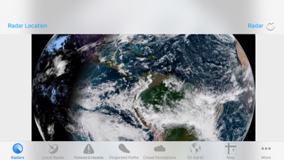
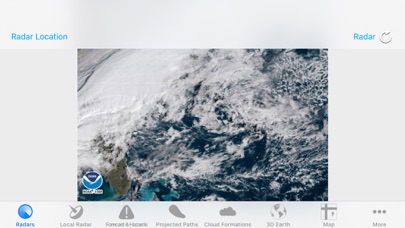
Hurricane Track 3.0 is the most advanced, modern, and easiest to use Hurricane Tracking and Radar application! Hurricane Track 3.0 features incredible new features such as 18 World Radars featuring the newly launched GOES-16 Satellite, a new customizable dynamic Local Radar using NEXRAD "next-generation radar" technology, Forecast and Hazard warnings, future projected tropical cyclone paths, Lightning Intensity Radars, Sea Temperatures, Cloud Formations that can potentially turn into tropical cyclones, Maps, an interactive 3D Earth, detailed tropical storm information and discussion, and much much more! Hurricane Track 3.0 brings the most advanced hurricane tracking technology to your fingertips, and the best part is Hurricane Track is Free!
Innovative Features!
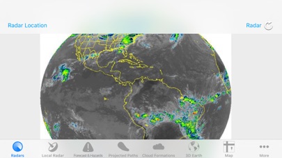
- 300+ World Radars: 18 Radar Locations around the globe with 17 Radars per Location
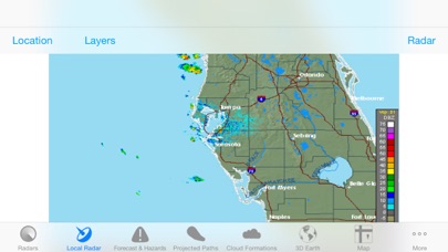
- Customizable Advanced Local Radar using NEXRAD technology (U.S. only)
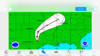
- Projected Tropical Storm paths: Future tropical storm paths for the next five days
- Forecast and Hazards give you detailed forecasts for different periods of the day, and hazards that you should look out for (Tornado Watch, Flood Warning, High Tide, etc.) (U.S. only, Updated hourly)
- Innovative Lightning Intensity Radars
- Interactive Map with Tropical Cyclones, Live Clouds, and Earthquakes
- Sea Surface Temperatures for the past two months
- Graphical outlines of cloud formations that can turn into potential Tropical Storms
- 3D Earth with Live Clouds, Tropical Storms, and Earthquakes
- Tropical Storm and Weather Information, Summaries, Discussions, and Outlooks
8 World Radars for 12 different Locations around the Globe!
- Visible - Unenhanced visible imagery that transitions to IR2 overnight
- Shortwave - Channel 2 Shortwave Infrared imagery - Shortwave, sometimes considered "night visible"
- Water Vapor - IR Channel 3
- Aviation - Aviation color enhancement
- Dvorak - Used for tropical classifications with the Dvorak technique
- JSL - Used to bring out low level and high level clouds in tropical cyclones
- Funktop - Higlights intense areas of precipitation
- Rainbow - Rainbow enhancement curve, colorful enhancement
Seven years ago, this was a hurricane app for the Atlantic only until I approached the developer to make some overall positive changes to this app to include the Eastern and Central Pacific including a radar map for the Hawaiian Islands.
Since that time, we’ve seen several GOES satellites come and go in which we lost some key features over the years.
On March 1,2022, NOAA launched the new GOES-T Satellite to be renamed to GOES-18 once it reaches it’s final orbit, which it did on May 13-22, 2022 after some orbital adjustments. This satellite will be renamed again in May 2023 to GOES-West after the next satellite launch here in a few months in the cue.
Some of those key features will come back with the next satellite launch such as the world Sea Surface Temperature Map( SST) Interactive and the South Eastern Pacific Radar Map Interactive with the next several weeks. This entire app is interactive and it much easier to sense the direction, speed, size and intensity of a named hurricane.
It’s a lot of labor and hard work involved to connect, match up data and update this interactive real time hurricane radar maps to this new GOES-18 Satellite feed but you will notice that these interactive Doppler Radar maps are like no other in Apple’s App Store currently.
Currently, the Hawaiian Islands are under hurricane threats from Bonnie, which was downgraded and Darby, which was just upgraded to a CAT 3 but will hopefully pass south of the Hawaiian Islands this weekend while we are experiencing Kings Tides.
On this Saturday, July 16 from 9am to 12noon, the Makani ‘Ino ARES Hurricane Drill will happen at the same time along with the RIMPAC 2022 Military Exercise to add some possible realistic data and Amateur Radio EmComm Communications that couldn’t have any better timing than this to add some realism to these important exercises.
With that said, this Hurricane App with be playing a key role with us doing mobile operations including on several military bases this coming Saturday morning. As the Net Controller for the Honolulu NWS SKYWARN Program at the University of Hawaii-Manoa Campus, this app is going to play a vital role for me while on the road and while going to each mobile preplanned location on my iPhone.
Please support this app as improvements will be made over the next couple of months. A big Mahalo!
Buggy
Every time I want to see the predicted hurricane track, it has to “load” 30-50 images. Why? Just show the hurricane of interest (let me “pin” it)
Also, in the hurricane forecast and discussion, the entire text is on ONE LINE. This is impossible to read.
Where’s the Hurricane
Hurricane Dorian is almost non-existent on this app. This was my favorite hurricane app for years but something has drastically change. When you open the app it automatically goes to the global weather which would be good if you could actually interact with it and zoom in or select an area of interest...
Please fix
On the main map, it shows a track for Isaac while completely omitting tracks for Florence, Helene and Gordon!
Too much missing, yet vital, weather and hurricane info. Deleting.
Awful data hog. Slow
Removing now. Forces to load 50 maps EVERY time I open it and every time I tap to choose a radar etc. And is worst data hog of any weather type app I have ever used and maybe any app. It just used about 40 megs of data in less than one minute!
App Will Not Load
First names storm of the year, so I was looking forward to opening up this app and tracking the storm. Of course, the app won’t open. It goes to the loading screen then crashes.
Hurricane Tracker
You must fix the lighting tab because when you click on the tab the app goes off. That is not supposed to happen. I just downloaded this app and I give it four stars. Can you also have in the radar maps Atlantic and Pacific areas. Can you also go through the entire app and see what tabs are work and which one are not working and fix then all. Make the app more realistic on everything that is in it and possibly add new features.
Where's Irma?
Can't find Irma, most dangerous storm and I can't track it!
Where is Irma?
It is September 5th, the big news of the day is Irma a Cat. 5 hurricane. Looking at the Atlantic I see the track for Jose but where is Irma the more imminent threat?
Bad app!!
This app is horrible! Takes forever and a day to load! Freezes up. Info not up to date as your local weather! Do not get!
Loaded with ads that block the page!