Description
This App offers access to marine vector covering German waters (derived from BSH data). First marine GPS app to have route assistance with Voice Prompts for marine navigation. You can create new boating routes or import existing GPX/KML routes. It supports Nautical Charts course up orientation. Includes Tide & Currents prediction.
►FEATURES
√ Beautiful and detailed Hardware/GPU accelerated vector charts (text stays upright on rotation)
√ Long press to query the details of Marine object (Buoy, Lights, Obstruction etc).
√ Customizable depth(Ft/Fathom/Meter) and distance units (km/mi/NM)
√ Customizable Shallow Depth.
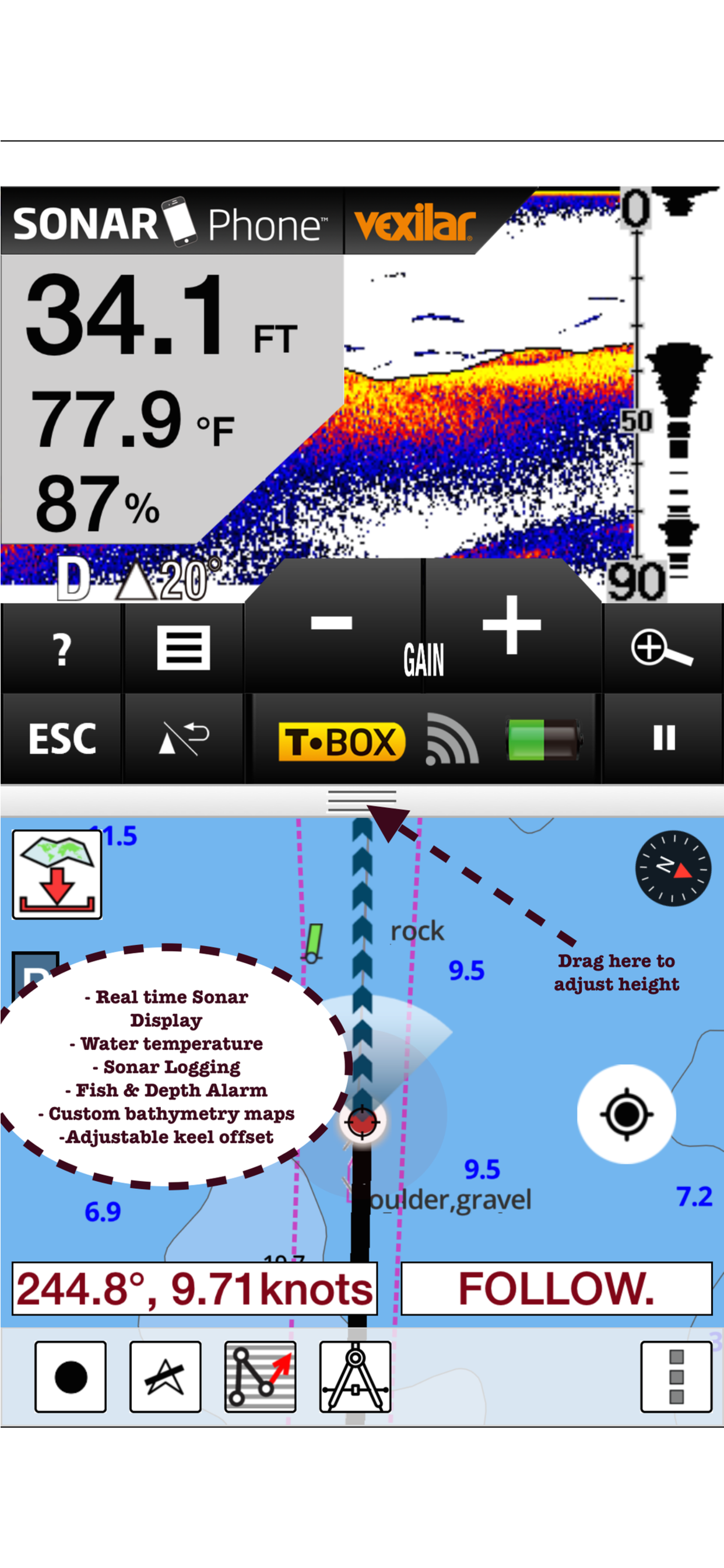
√ Record tracks, Autofollow with real-time track overlay & predicted path vector.
√ Voice Prompts for marine navigation (requires GPS )
√ 1ft / 3ft depth contour maps for anglers for selected lake maps.
√ Supports GPX/KML for boating route editing/import.
√ Tide & Currents prediction.
√ Seamless chart quilting of marine charts
√ Enter or import Waypoints.
► MAPS
The maps include coverage of Germany (both coastal and inland waters) (derived from BSH data).
►ROUTE MANAGEMENT / TRIP PLANNING
√ Create New Route/Edit Existing Routes
√ Move Points
√ Add points to an existing route leg
√ Delete / Rename points
√ Import GPX, KML & KMZ files
√ Plot/Edit Routes
√ Enter Waypoints
√ Share/Export Routes, Tracks & Markers
√ Reverse Routes
►GPS FEATURES
√ Auto Follow
* Real Time Track Overlay
* Predicted Path Vector
* Course Up (Text stays upright)
* Speed & Heading
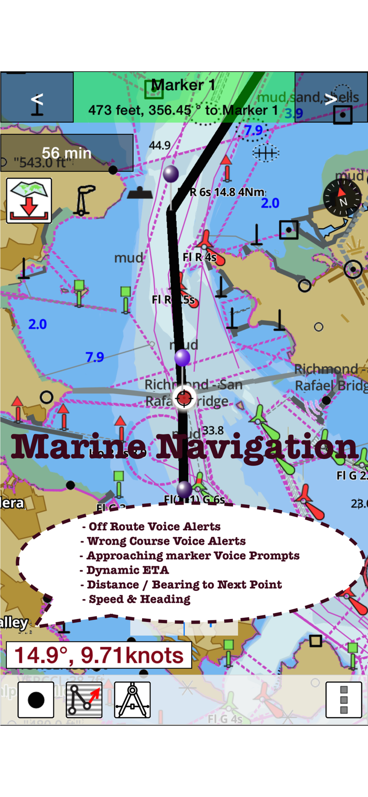
√ Route Assistance With Voice Prompts
* Prompts when approaching a boating route marker
* Continous distance and ETA updates
* Alerts when sailing/boating off route
* Alerts when boating in wrong direction
√ Record Tracks
►TIDE & CURRENTS
* For US, Canada, UK, Germany & New Zealand
* High/Low Tides
* Tidal Current Prediction
* Active Current Stations
► SHARING
* Share tracks/routes/markers on Facebook & Twitter
* Export tracks/routes/markers as compressed GPX files.
Sample Nautical Charts (please visit http://gpsnauticalcharts.com/main/de-nautical-charts-by-folio.html)
►Dysentery
►Berlin-Spandau navigation canal
►Spree-Oder Waterway
►Rhine-Herne Canal
►Wesel-Datteln Canal
►Elbe-Havel Canal
►Lower Havel Waterway (Spandau - Plaue)
►Saar
►Dortmund-Ems Canal
►Elbe Lateral Canal
►Weser
►Rhine-Main-Danube Canal
►Havel-Oder Waterway
►West Or
►Neckar
►Danube
►Moselle
►Mittellandkanal
►Main
►North Sea
►Rhine
►Elbe
►Baltic Sea
Hide
Show More...
►FEATURES
√ Beautiful and detailed Hardware/GPU accelerated vector charts (text stays upright on rotation)
√ Long press to query the details of Marine object (Buoy, Lights, Obstruction etc).
√ Customizable depth(Ft/Fathom/Meter) and distance units (km/mi/NM)
√ Customizable Shallow Depth.
√ Record tracks, Autofollow with real-time track overlay & predicted path vector.
√ Voice Prompts for marine navigation (requires GPS )
√ 1ft / 3ft depth contour maps for anglers for selected lake maps.
√ Supports GPX/KML for boating route editing/import.
√ Tide & Currents prediction.
√ Seamless chart quilting of marine charts
√ Enter or import Waypoints.
► MAPS
The maps include coverage of Germany (both coastal and inland waters) (derived from BSH data).
►ROUTE MANAGEMENT / TRIP PLANNING
√ Create New Route/Edit Existing Routes
√ Move Points
√ Add points to an existing route leg
√ Delete / Rename points
√ Import GPX, KML & KMZ files
√ Plot/Edit Routes
√ Enter Waypoints
√ Share/Export Routes, Tracks & Markers
√ Reverse Routes
►GPS FEATURES
√ Auto Follow
* Real Time Track Overlay
* Predicted Path Vector
* Course Up (Text stays upright)
* Speed & Heading
√ Route Assistance With Voice Prompts
* Prompts when approaching a boating route marker
* Continous distance and ETA updates
* Alerts when sailing/boating off route
* Alerts when boating in wrong direction
√ Record Tracks
►TIDE & CURRENTS
* For US, Canada, UK, Germany & New Zealand
* High/Low Tides
* Tidal Current Prediction
* Active Current Stations
► SHARING
* Share tracks/routes/markers on Facebook & Twitter
* Export tracks/routes/markers as compressed GPX files.
Sample Nautical Charts (please visit http://gpsnauticalcharts.com/main/de-nautical-charts-by-folio.html)
►Dysentery
►Berlin-Spandau navigation canal
►Spree-Oder Waterway
►Rhine-Herne Canal
►Wesel-Datteln Canal
►Elbe-Havel Canal
►Lower Havel Waterway (Spandau - Plaue)
►Saar
►Dortmund-Ems Canal
►Elbe Lateral Canal
►Weser
►Rhine-Main-Danube Canal
►Havel-Oder Waterway
►West Or
►Neckar
►Danube
►Moselle
►Mittellandkanal
►Main
►North Sea
►Rhine
►Elbe
►Baltic Sea
Screenshots


I-Boating FAQ
-
Is I-Boating free?
Yes, I-Boating is completely free and it doesn't have any in-app purchases or subscriptions.
-
Is I-Boating legit?
Not enough reviews to make a reliable assessment. The app needs more user feedback.
Thanks for the vote -
How much does I-Boating cost?
I-Boating is free.
-
What is I-Boating revenue?
To get estimated revenue of I-Boating app and other AppStore insights you can sign up to AppTail Mobile Analytics Platform.

User Rating
App is not rated in New Zealand yet.
Ratings History
I-Boating Reviews
Store Rankings
Ranking History
App Ranking History not available yet
Category Rankings
|
Chart
|
Category
|
Rank
|
|---|---|---|
|
Top Paid
|

|
359
|
|
Top Paid
|

|
427
|
I-Boating Competitors
| Name | Downloads (30d) | Monthly Revenue | Reviews | Ratings | Recent release | |
|---|---|---|---|---|---|---|

SkippersNotes: Boat trip log
nautical journal & speedometer
|
Unlock
|
Unlock
|
0
|
|
2 months ago | |

SeaHelp
Sea assistance service
|
Unlock
|
Unlock
|
0
|
|
2 months ago | |

MyCaravaning
|
Unlock
|
Unlock
|
0
|
|
1 month ago | |
Port-Guide
Der Hafenführer für unterwegs.
|
Unlock
|
Unlock
|
0
|
|
2 years ago | |

Yacht Navigator|Kartenplotter
Plotter für Sportbootkarten
|
Unlock
|
Unlock
|
0
|
|
1 year ago | |

FindShip Pro - Track vessels
AIS Ship Tracking
|
Unlock
|
Unlock
|
0
|
|
1 month ago | |

Skippers Log
The logbook for your yacht
|
Unlock
|
Unlock
|
0
|
|
2 weeks ago | |
Canaux - Tourisme fluvial
Guide de navigation fluviale
|
Unlock
|
Unlock
|
0
|
|
3 weeks ago | |

Camping Village Šimuni
N/A
|
Unlock
|
Unlock
|
0
|
|
5 months ago | |

Megapark Official
|
Unlock
|
Unlock
|
0
|
|
7 months ago |
I-Boating Installs
Last 30 days
I-Boating Revenue
Last 30 daysI-Boating Revenue and Downloads
Gain valuable insights into I-Boating performance with our analytics.
Sign up now to access downloads, revenue, and more.
Sign up now to access downloads, revenue, and more.
App Info
- Category
- Travel
- Publisher
-
Bist

- Languages
- Dutch, English, Finnish, French, German, Norwegian Bokmål, Russian, Swedish
- Recent release
- 114.0.0 (2 years ago )
- Released on
- Nov 5, 2015 (9 years ago )
- Also available in
- Germany , Italy , Israel , Japan , South Korea , Kuwait , Kazakhstan , Lebanon , Mexico , Malaysia , Nigeria , Netherlands , Norway , New Zealand , Peru , Philippines , Pakistan , Poland , Portugal , Romania , Russia , Saudi Arabia , Sweden , Singapore , Thailand , Türkiye , Taiwan , Ukraine , United States , Vietnam , South Africa , Denmark , Argentina , Austria , Australia , Azerbaijan , Belgium , Bulgaria , Brazil , Belarus , Canada , Switzerland , Chile , China , Colombia , Czechia , India , Dominican Republic , Algeria , Ecuador , Egypt , Spain , Finland , France , United Kingdom , Greece , Hong Kong SAR China , Hungary , Indonesia , Ireland , United Arab Emirates
- Last Updated
- 5 days ago
This page includes copyrighted content from third parties, shared solely for commentary and research in accordance with fair use under applicable copyright laws. All trademarks, including product, service, and company names or logos, remain the property of their respective owners. Their use here falls under nominative fair use as outlined by trademark laws and does not suggest any affiliation with or endorsement by the trademark holders.