Inutile
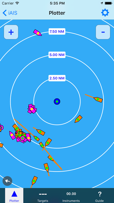
Cette appli ne montre pas les cibles sur l’écran. Je n’en vois donc pas l’intérêt.


Yes, iAIS is free to download, however it contains in-app purchases or subscription offerings.
🤔 The iAIS app's quality is mixed. Some users are satisfied, while others report issues. Consider reading individual reviews for more context.
iAIS has several in-app purchases/subscriptions, the average in-app price is €9.99.
To get estimated revenue of iAIS app and other AppStore insights you can sign up to AppTail Mobile Analytics Platform.

2.5 out of 5
8 ratings in France
Cette appli ne montre pas les cibles sur l’écran. Je n’en vois donc pas l’intérêt.
Just missing a collision course alarm.
cette appli vous renvoie sur une autre payante .... procédé malhonnête.... mauvais point pour digital yacht vaudrait mieux arrêter de genre de bidouille pas digne de pro..
pas grand intérêt, vous obligé à payer une option chez navionics pour voir les cartes. malgré la wifi, les cibles AIS n’apparaissent pas alors que c’est le seul intérêt de cette appli !!! seulement les indications de vitesse et de position donc aucun intérêt.
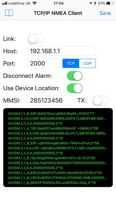
Ça marche vraiment. Suffit d'avoir un miniplex 2wi et un récepteur ais. Après, pas besoin de mode d'emplois. C'est une très belle réalisation car simple, rapide et efficace. Maintenant, vu ce qui est nécessaire pour le faire fonctionner, je doute de l'importance d'une telle application...
App stürzt sofort ab sobald mit ais Transponder verbunden. Also komplett nutzlos
Leider kann man den Bildschirm nicht gewohnt zoomen Der ais Receiver ist erforderlich da die Daten über das Internet nur dann erscheinen wenn es jemand freundlicher weise einstellt Beim Fahren mit einem Schiff nicht zu gebrauchen und zu gefährlich
Warum man heute noch einen zusätzlichen WLAN fähigen Receiver benötigt, erschließt sich mir nicht. Gerade Binnen oder küstennah könnte man das über die Datenverbindung abrufen... Die Anbindung an NAVIONICS kostete mich auch noch 10 Euro... So ist die Software völlig sinnlos...
I have a Kannad SafeLink R10 AIS Recovery System fitted to the lifejacket of the lonely man on the nightwatch. I can See the R10 on your App. It would be very good to have an alert, when the R10 (or any other AIS SART) is sending it's special MOB code. Tank you. :-)
Zum Empfang der Daten ist zusätzlich der Receiver erforderlich, der über den Handel zu beziehen ist. Dieser gibt wohl die Daten per eingebautem WLAN an das IPad iPhone weiter. Digital Yacht iAIS 2 Kanal AIS Receiver mit WIFI USB I/O Ca 489,- EUR
|
Chart
|
Category
|
Rank
|
|---|---|---|
|
Top Grossing
|

|
58
|
|
Top Free
|

|
443
|
|
Top Free
|

|
491
|
| Name | Downloads (30d) | Monthly Revenue | Reviews | Ratings | Recent release | |
|---|---|---|---|---|---|---|

AIS Maps: Marine & Lake charts
Detailed nautical & topo maps
|
Unlock
|
Unlock
|
5
|
|
1 month ago | |

Atlas Cartes Nautiques
Mers et Lacs Cartes Nautiques
|
Unlock
|
Unlock
|
1
|
|
1 year ago | |

SailFreeGPS
Sailing navigation intruments
|
Unlock
|
Unlock
|
3
|
|
4 weeks ago | |

NV Charts GPS Navigation AIS
Navigation maritime et boating
|
Unlock
|
Unlock
|
18
|
3
|
5 months ago | |

B&G: Companion App for Sailors
La cartographie de navigation
|
Unlock
|
Unlock
|
14
|
|
1 month ago | |

SeaNav
Marine Charts and Navigation
|
Unlock
|
Unlock
|
4
|
|
1 month ago | |

qtVlm
Navigation et routage météo
|
Unlock
|
Unlock
|
20
|
|
2 weeks ago | |

Radar de Navire
|
Unlock
|
Unlock
|
10
|
|
3 days ago | |

OnCourse - boating & sailing
Navigation - mAIS
|
Unlock
|
Unlock
|
3
|
|
1 week ago | |

Marine Radar
|
Unlock
|
Unlock
|
3
|
|
7 months ago |
