iSailGPS NZ : NZ Marine Charts
New Zealand RNC Marine Charts
#1 Keyword Rankings
Today
Top 10 Rankings
Today
Top 30 Rankings
Today
Top 100 Rankings
Today
Description
Unleash the navigation potential of your iPhone or iPad with SailGPS NZ! Turn your device into a high-performance GPS receiver with LINZ RNC Nautical Charts, even without a cell signal!
Caught in a storm on the water and your chart plotter fails? Don't worry! Download this app now and regain navigation capabilities to safely return to port. Better yet, buy iSailGPS NZ today ensuring you're prepared for any situation, even in areas with no cell service.
One Low Price! Everything included. No sign-ups, ads, subscriptions or in-app purchases. Completely respects your privacy.
Unrivaled Features to Enhance Your Journey:
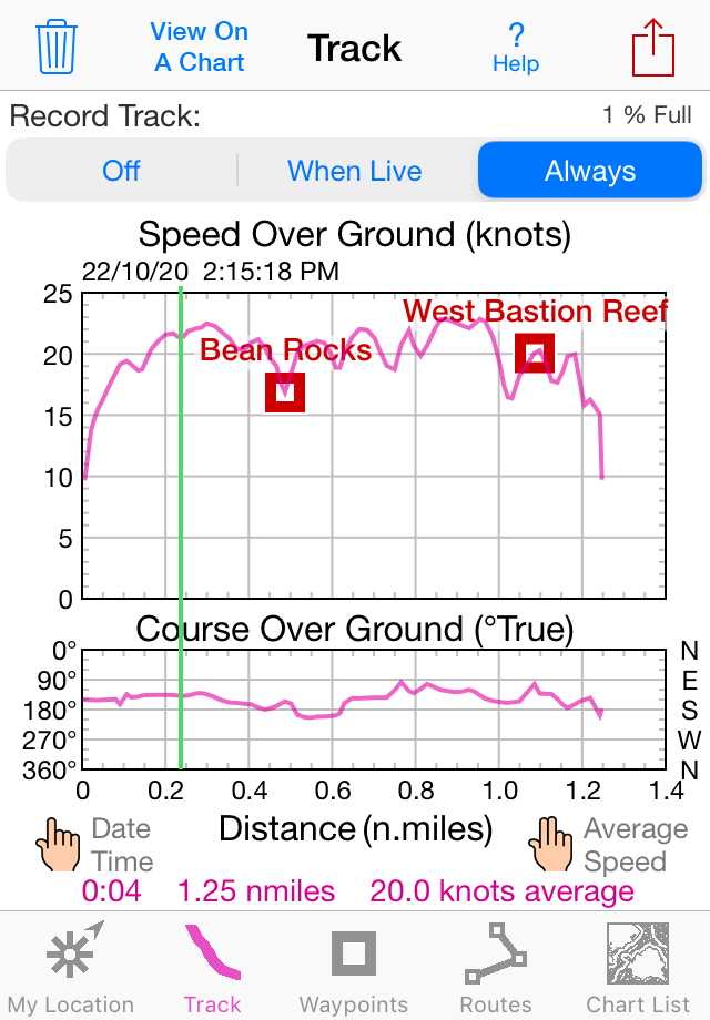
TRACKS, WAYPOINTS & ROUTES
Record tracks as you sail, even in the background. View them on the chart and in a Speed & Course Over Ground graph.
Mark waypoints precisely using charts or satellite maps, place names or addresses, geotagged photos, or by projecting from a known point.
Set a quick GoTo waypoint or a full route and see the course (COG), heading (HDG), bearing (BRG), direction, distance, cross track error (XTE), Velocity Made Good (VMG) and Estimated Time of Arrival (ETA) at your destination and intermediate points. Perfect for racing enthusiasts.
In a Man Overboard (MOB) emergency a single button press marks your current position & starts navigating to it.
Create customized routes using waypoints, recorded tracks, or imported GPX, KML or TCX files. Advanced route editing.
Send GPX and KML waypoint, route, track and map list files via AirDrop, eMail, Messages or iCloud Drive.
View the sun & moon position, rise times & set times for any date and place on earth.
Send data to other apps such as Google Earth.
LAND INFORMATION NEW ZEALAND MARINE CHARTS
Access all LINZ NZ Raster Nautical Charts with no extra charge. These charts had their final update on 7/12/23. There will be no further updates.
Our charts are optimized to download faster using WiFi or cell service. Store a few charts or charts for the whole country to use anytime without cell service.
Stitches Mercator charts & automatically switches between downloaded charts as you sail. Choose detailed or overview charts.
Enjoy the high resolution and what's-all-around detail of these NZ Nautical Charts (RNC). They are a welcome advantage over Vector Charts, which only show a coastline, depths, navigation aids, and minimal details.
Print and Share chart images overlaid with waypoints, routes & tracks.
Measure distance between any two points.
USE YOUR PREFERRED UNITS
Kilometers, Miles or Nautical Miles.
Meters or Feet.
Degrees, Degrees/Minutes, Degrees/Minutes/Seconds, UTM or NZTM2000 grid.
°True or °Magnetic.
HOW TOS
Tap Help in the app.
Online Manual: iSailGPS.com/nz
Email developer: [email protected]
RASTER CHARTS vs. VECTOR CHARTS
The Land Information New Zealand Raster Nautical Charts in iSailGPS NZ differ from computer-drawn vector ENC charts in that each chart covers a specific area, the same way a paper nautical chart does. Switches automatically to a new chart when you leave the area covered by the previous chart. For many locations, there are multiple charts at different scales with different levels of detail & areas of coverage.
Paper charts can contain multiple panels, each showing a different area or scale. Each digital panel is individually displayed by iSailGPS NZ with a north-up orientation.
iSail GPS NZ is priced to make it readily available to all boating enthusiasts.
iSailGPS NZ and the charts that it includes do NOT meet the legal requirements for navigation using charts that you may be required to carry.
DEVICE REQUIREMENTS
Use iSailGPS on any iOS device even if you don't have a cellular data plan for it. iPhones & WiFi+cellular iPads support all features. For WiFi-only iPads, an iOS-compatible external GPS receiver is required to show your location & record tracks. You can view charts using the iOS device alone.
Discover a safer and more enjoyable sailing experience with iSailGPS NZ!
Hide..
Show more..
Caught in a storm on the water and your chart plotter fails? Don't worry! Download this app now and regain navigation capabilities to safely return to port. Better yet, buy iSailGPS NZ today ensuring you're prepared for any situation, even in areas with no cell service.
One Low Price! Everything included. No sign-ups, ads, subscriptions or in-app purchases. Completely respects your privacy.
Unrivaled Features to Enhance Your Journey:
TRACKS, WAYPOINTS & ROUTES
Record tracks as you sail, even in the background. View them on the chart and in a Speed & Course Over Ground graph.
Mark waypoints precisely using charts or satellite maps, place names or addresses, geotagged photos, or by projecting from a known point.
Set a quick GoTo waypoint or a full route and see the course (COG), heading (HDG), bearing (BRG), direction, distance, cross track error (XTE), Velocity Made Good (VMG) and Estimated Time of Arrival (ETA) at your destination and intermediate points. Perfect for racing enthusiasts.
In a Man Overboard (MOB) emergency a single button press marks your current position & starts navigating to it.
Create customized routes using waypoints, recorded tracks, or imported GPX, KML or TCX files. Advanced route editing.
Send GPX and KML waypoint, route, track and map list files via AirDrop, eMail, Messages or iCloud Drive.
View the sun & moon position, rise times & set times for any date and place on earth.
Send data to other apps such as Google Earth.
LAND INFORMATION NEW ZEALAND MARINE CHARTS
Access all LINZ NZ Raster Nautical Charts with no extra charge. These charts had their final update on 7/12/23. There will be no further updates.
Our charts are optimized to download faster using WiFi or cell service. Store a few charts or charts for the whole country to use anytime without cell service.
Stitches Mercator charts & automatically switches between downloaded charts as you sail. Choose detailed or overview charts.
Enjoy the high resolution and what's-all-around detail of these NZ Nautical Charts (RNC). They are a welcome advantage over Vector Charts, which only show a coastline, depths, navigation aids, and minimal details.
Print and Share chart images overlaid with waypoints, routes & tracks.
Measure distance between any two points.
USE YOUR PREFERRED UNITS
Kilometers, Miles or Nautical Miles.
Meters or Feet.
Degrees, Degrees/Minutes, Degrees/Minutes/Seconds, UTM or NZTM2000 grid.
°True or °Magnetic.
HOW TOS
Tap Help in the app.
Online Manual: iSailGPS.com/nz
Email developer: [email protected]
RASTER CHARTS vs. VECTOR CHARTS
The Land Information New Zealand Raster Nautical Charts in iSailGPS NZ differ from computer-drawn vector ENC charts in that each chart covers a specific area, the same way a paper nautical chart does. Switches automatically to a new chart when you leave the area covered by the previous chart. For many locations, there are multiple charts at different scales with different levels of detail & areas of coverage.
Paper charts can contain multiple panels, each showing a different area or scale. Each digital panel is individually displayed by iSailGPS NZ with a north-up orientation.
iSail GPS NZ is priced to make it readily available to all boating enthusiasts.
iSailGPS NZ and the charts that it includes do NOT meet the legal requirements for navigation using charts that you may be required to carry.
DEVICE REQUIREMENTS
Use iSailGPS on any iOS device even if you don't have a cellular data plan for it. iPhones & WiFi+cellular iPads support all features. For WiFi-only iPads, an iOS-compatible external GPS receiver is required to show your location & record tracks. You can view charts using the iOS device alone.
Discover a safer and more enjoyable sailing experience with iSailGPS NZ!
Screenshots


 User Rating
0 out of 5
0 ratings in Canada
Ratings History
Reviews
App doesn't have any reviews yet
Store Rankings
Ranking History
App Ranking History not available yet
Category Rankings
|
Chart
|
Category
|
Rank
|
|---|---|---|
|
Top Paid
|

|
13
|
|
Top Grossing
|
|
91
|
|
Top Paid
|

|
104
|
|
Top Paid
|

|
156
|
|
Top Paid
|

|
181
|
Keywords
Users may also like
| Name | Reviews | Recent release | |
|---|---|---|---|

Rankers Camping NZ
Legit NZ campsites
|
9
|
5 days ago | |

NZ Traffic Cameras & Updates
New Zealand Live Traffic Cam
|
0
|
4 months ago | |

Orca: Boat GPS, Charts, Routes
GPS Chart Route Sail Powerboat
|
1
|
1 week ago | |

SailFreeGPS
Sailing navigation intruments
|
0
|
11 months ago | |

WinGPS Marine
|
1
|
1 month ago | |

SEAiq
|
8
|
2 weeks ago | |

PredictWind Race Tracker
|
1
|
4 weeks ago | |

NMEA GPS Tether
|
0
|
2 years ago | |

SailTies: Logbook GPS Tracking
Sailing Resume, Qualifications
|
2
|
4 weeks ago | |

Cruise Guide for Marlborough
|
0
|
2 months ago |
Show More
Revenue and Downloads
Gain valuable insights into iSailGPS NZ : NZ Marine Charts performance with our analytics. Sign up now
to
access downloads, revenue, and more.
App Info
- Category
- Navigation
- Publisher
- James Associates Inc.
- Languages
- English
- Recent version
- 9.4.8 (2 weeks ago )
- Released on
- Sep 14, 2014 (9 years ago )
- Also available in
- New Zealand, Australia, Pakistan, Italy, Japan, South Korea, Kuwait, Kazakhstan, Lebanon, Mexico, Malaysia, Nigeria, Netherlands, Norway, Peru, Philippines, India, Poland, Portugal, Romania, Saudi Arabia, Sweden, Singapore, Thailand, Turkey, Taiwan, Ukraine, United States, Vietnam, South Africa, Dominican Republic, Argentina, Austria, Azerbaijan, Belgium, Brazil, Canada, Switzerland, Chile, China, Colombia, Czechia, Germany, Denmark, United Arab Emirates, Algeria, Ecuador, Egypt, Spain, Finland, France, United Kingdom, Greece, Hong Kong, Hungary, Indonesia, Ireland, Israel
- Last updated
- 2 weeks ago