
Japan Chart Navi
#1 Keyword Rankings
Today
Top 10 Rankings
Today
Top 30 Rankings
Today
Top 100 Rankings
Today
Description
***********************
This is a free version for tests. Please try this before you purchase the paid version.
AppStore search screen "map of the sea" to search on other series will be displayed. All 45 will be commercialized by Japan in the Y map charts a single unit. Please wait for a while.
***********************
(To use a lot of memory, iPhone3GS is officially supported or more)
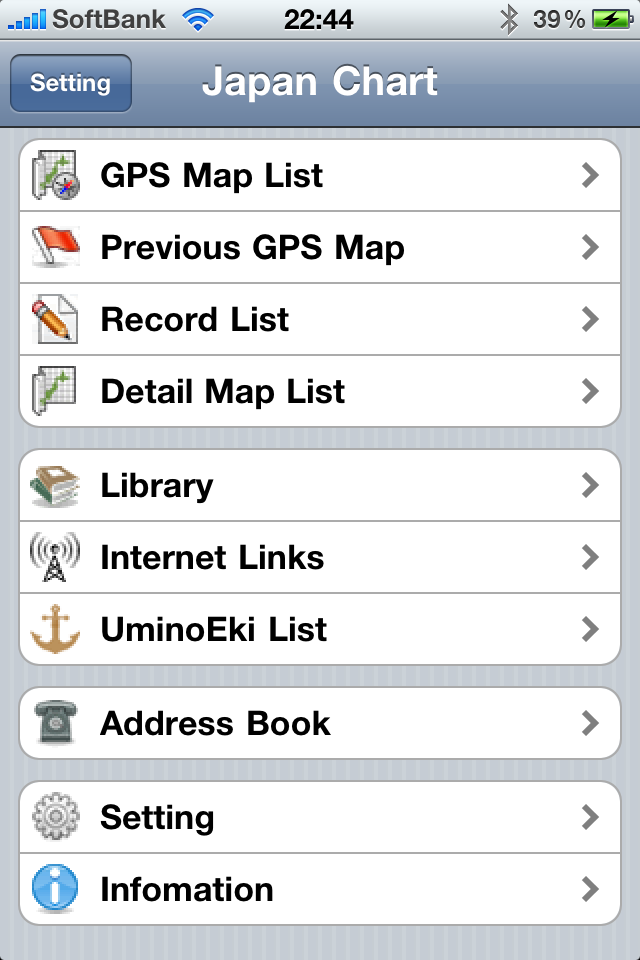
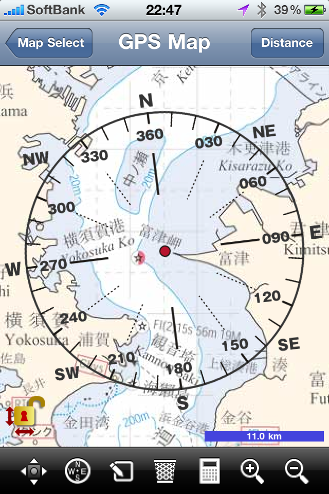
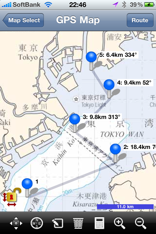
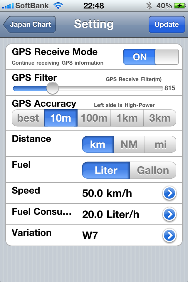
"The iPhone in the sea!" We developed this product based on this slogan. "Navigation map of the sea" is, GPS measured at sea using the current position, orientation to the destination, distance, and for marine navigation applications use to measure the approximate fuel.
Even out of radio at sea, map (Y chart), so in the application has data to confirm the orientation can determine the current location and destination. Jet ski (Jet Marine), and motorboats as, GPS was not designed for use with small boats. iPhone waterproof pack (sold separately) into, the sea is also please phone us. Pick up a signal in coastal areas of Mobile, GPS to locate the precise, you can also request a quick rescue. It also features fuel and easy calculation, you can drift by as much as possible to prevent gas. (Thank you for such use to reference only)
This app, like the Coast Guard Authorization "number of 222 505 Coast Guard permit" (based on publications like Business Law Article 25 water) has received. Partnership with Japan Hydrographic Association also like the latest "for example - motorboat yacht (Y Chart)" is used.
The information is displayed to confirm the position of own ship. For more information about the time of sailing, please use the chart. Datum is used in this figure, "Datum world."
"Map of the Sea Navigation (Select 1)" There are 45 in all. Check the map, like the site Hydrographic Association, "Internet shopping chart" Please confirm. "For example - yacht and motorboat (Y Chart)" You can see a map of the 45 items. The paper map also "Internet shopping chart" I have sold, according Please utilize.
All content and maps please reference purposes only. Regarding the accident using this app, we can not assume any responsibility.
GPS in commercial vessels is common in the leisure boat or jet ski facilities are still not common. The accidents in Japan, I really wish to reduce a little.
Hide..
Show more..
This is a free version for tests. Please try this before you purchase the paid version.
AppStore search screen "map of the sea" to search on other series will be displayed. All 45 will be commercialized by Japan in the Y map charts a single unit. Please wait for a while.
***********************
(To use a lot of memory, iPhone3GS is officially supported or more)
"The iPhone in the sea!" We developed this product based on this slogan. "Navigation map of the sea" is, GPS measured at sea using the current position, orientation to the destination, distance, and for marine navigation applications use to measure the approximate fuel.
Even out of radio at sea, map (Y chart), so in the application has data to confirm the orientation can determine the current location and destination. Jet ski (Jet Marine), and motorboats as, GPS was not designed for use with small boats. iPhone waterproof pack (sold separately) into, the sea is also please phone us. Pick up a signal in coastal areas of Mobile, GPS to locate the precise, you can also request a quick rescue. It also features fuel and easy calculation, you can drift by as much as possible to prevent gas. (Thank you for such use to reference only)
This app, like the Coast Guard Authorization "number of 222 505 Coast Guard permit" (based on publications like Business Law Article 25 water) has received. Partnership with Japan Hydrographic Association also like the latest "for example - motorboat yacht (Y Chart)" is used.
The information is displayed to confirm the position of own ship. For more information about the time of sailing, please use the chart. Datum is used in this figure, "Datum world."
"Map of the Sea Navigation (Select 1)" There are 45 in all. Check the map, like the site Hydrographic Association, "Internet shopping chart" Please confirm. "For example - yacht and motorboat (Y Chart)" You can see a map of the 45 items. The paper map also "Internet shopping chart" I have sold, according Please utilize.
All content and maps please reference purposes only. Regarding the accident using this app, we can not assume any responsibility.
GPS in commercial vessels is common in the leisure boat or jet ski facilities are still not common. The accidents in Japan, I really wish to reduce a little.
In-Apps
- TOKYO - CHIBA
- £11.99
- Sanin Simple Map
- £0.99
- Tohoku Simple Map
- £0.99
- TATEYAMA - CHIKURA
- £11.99
- TSURUGA - TAKAHAMA
- £11.99
- YOKOHAMA - KISARAZU
- £11.99
- KARATSU WAN - IKI SHIMA
- £11.99
- SHIMODA - SHIKINE SHIMA
- £11.99
- EASTERN PART of SURUGA WAN
- £11.99
- East Japan Yachting Charts Package
- £189.99
Screenshots

 User Rating
0 out of 5
0 ratings in United Kingdom
Ratings History
Reviews
App doesn't have any reviews yet
Store Rankings
Ranking History
App Ranking History not available yet
Category Rankings
|
Chart
|
Category
|
Rank
|
|---|---|---|
|
Top Free
|

|
500
|
Keywords
Users may also like
| Name | Reviews | Recent release | |
|---|---|---|---|

Toward
shows distance and direction
|
1
|
3 years ago | |

Aisea PRO - アイシア
船舶の業務をサポートし、安全性を向上します
|
0
|
5 months ago | |

Aisea - Sailing support app.
For all boat operators.
|
0
|
2 years ago | |
海の駅
|
0
|
6 months ago | |

AR Island Map
島や海岸にかざすとARで名前が表示されます
|
0
|
2 months ago | |

マリンコンパス - 小型船舶やボートの安全・安心ネットワーク
|
0
|
1 week ago | |

フィッシング & ボート BLUE
釣り&ボートライフをサポート!
|
0
|
1 year ago | |

umico / ウミコ Lite
|
0
|
1 year ago |
Show More
Revenue and Downloads
Gain valuable insights into Japan Chart Navi performance with our analytics. Sign up now
to
access downloads, revenue, and more.
App Info
- Category
- Navigation
- Publisher
- FujiDenshiDotCom
- Languages
- English, Japanese
- Recent version
- 4.0 (8 years ago )
- Released on
- Jul 20, 2010 (14 years ago )
- Also available in
- Japan, United States, Russia, France, Australia, Brazil, Israel, Romania, Saudi Arabia, Nigeria, Philippines, Peru, New Zealand, Norway, Netherlands, Portugal, Malaysia, Lebanon, Kazakhstan, Pakistan, Poland, Italy, Sweden, Singapore, Thailand, Turkey, Taiwan, Ukraine, Vietnam, South Africa, South Korea, Azerbaijan, Belgium, Belarus, Switzerland, China, Czechia, Germany, Denmark, Dominican Republic, Algeria, Egypt, Spain, Finland, United Kingdom, Greece, Hong Kong, Hungary, Indonesia, Ireland, India, United Arab Emirates, Kuwait, Austria, Argentina
- Last updated
- 1 month ago