Top end trip
I found this app was a tremendous backup on my recent trip across the top end from Broome to Cape York, then down to Brisbane

Yes, Compass 55 is free to download, however it contains in-app purchases or subscription offerings.
✅ The Compass 55 app appears to be high-quality and legitimate. Users are very satisfied.
Compass 55 has several in-app purchases/subscriptions, the average in-app price is $9.99.
To get estimated revenue of Compass 55 app and other AppStore insights you can sign up to AppTail Mobile Analytics Platform.

4.56 out of 5
78 ratings in Australia
I found this app was a tremendous backup on my recent trip across the top end from Broome to Cape York, then down to Brisbane
Its a great back up for flying as well.!! Great. Highly recommended.
I won't to be truthful about this compass It's the best I have ever used in my life There are more & more people getting . Lost every day if you had this compass You would be safe & find it so useful But get to no this compass first There's a lot of tools on here to help you So please get to no your tool first Thank you for such a great compass As I am in the R.F.S.A I have used this Compass & I'm still here DAVID
It’s kool
A very well designed and acutely handy app for all things navigation. Got disoriented in the bush one day but Compass 55 got me out of the mess. Recommended
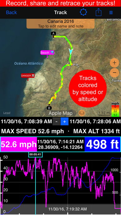
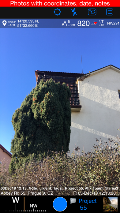
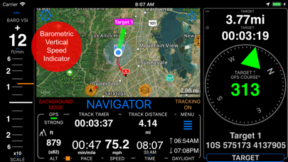
That’s what I use it for mostly. It is simple to use once you work it out and the Developer was quick to respond when I had a query. That it works when there’s no ph service is important to me; once back in service, all the Maps show but importantly when not in service, you will always be taken to your Target even tho no map shows - the ‘rubber band’ guide draws you towards your Target. You can download maps if u rarely have service and want to see terrain but I haven’t really had the need. Good info of distance, speed, ave speed, times, coordinates and alt. Excellent excellent App. Excellent storage for previous trips. All in all, very nice App for any traveling and only a one off cost of few dollars.
i have been using this tracker for nearly 2years now and cant fault it always gets me back definately the best tracker on iphone
Love this app. Does everything I need it to do. Would be good to get some augmented reality for waypoints though. Otherwise keep up the good work
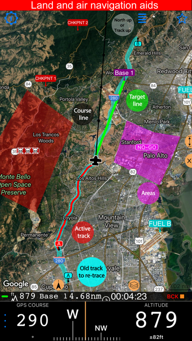
Our CFS brigade volunteers use this app on their iPhones since it lets us work in UTM for both display of our location as well as the entry of coordinates for waypoints to navigate to. Being able to navigate by baring and distance or Google maps is perfect. Thanks for the great app!
Great app I do a lot of gold detecting and this app saves me buying a gps
|
Chart
|
Category
|
Rank
|
|---|---|---|
|
Top Grossing
|

|
17
|
|
Top Grossing
|

|
22
|
|
Top Grossing
|

|
33
|
|
Top Grossing
|

|
44
|
|
Top Grossing
|

|
45
|
| Name | Downloads (30d) | Monthly Revenue | Reviews | Ratings | Recent release | |
|---|---|---|---|---|---|---|

Guru Maps - Offline Navigation
Route Planner, Offroad Trails
|
View
|
View
|
20
|
|
1 week ago | |

Commander Compass Go
Compass, GPS & Offline Maps
|
View
|
View
|
0
|
|
2 years ago | |

GPS & Maps: Location Tracker
Find Coordinates, Compass, POI
|
View
|
View
|
20
|
|
1 year ago | |

Navitel Navigator
GPS navigation & Offline maps
|
View
|
View
|
0
|
|
9 months ago | |

Topo Maps+
Offline Topographic Maps & GPS
|
View
|
View
|
8
|
|
2 days ago | |

Private Tracker
Minimalist OSM
|
View
|
View
|
0
|
|
10 months ago | |

Dane z GPS
|
View
|
View
|
0
|
|
2 months ago | |

Navigator for pedestrians
Voice Navigator for forest
|
View
|
View
|
0
|
|
2 years ago | |

Where2Go: Easy GPS Navigation
Compass for hiking and walking
|
View
|
View
|
0
|
|
3 years ago | |

3D Offline Maps: GPS tracker
Navigation,hiking trails, gpx
|
View
|
View
|
0
|
|
2 months ago |
