Topo Maps+
Offline Topographic Maps & GPS
#1 Keyword Rankings
Today
Top 10 Rankings
Today
Top 30 Rankings
Today
Top 100 Rankings
Today

Description

Designed and tested on real dirt, Topo Maps+ is packed with good planning tools, trustworthy maps, on-trail tools, and tips to plan big and return safe & sound.
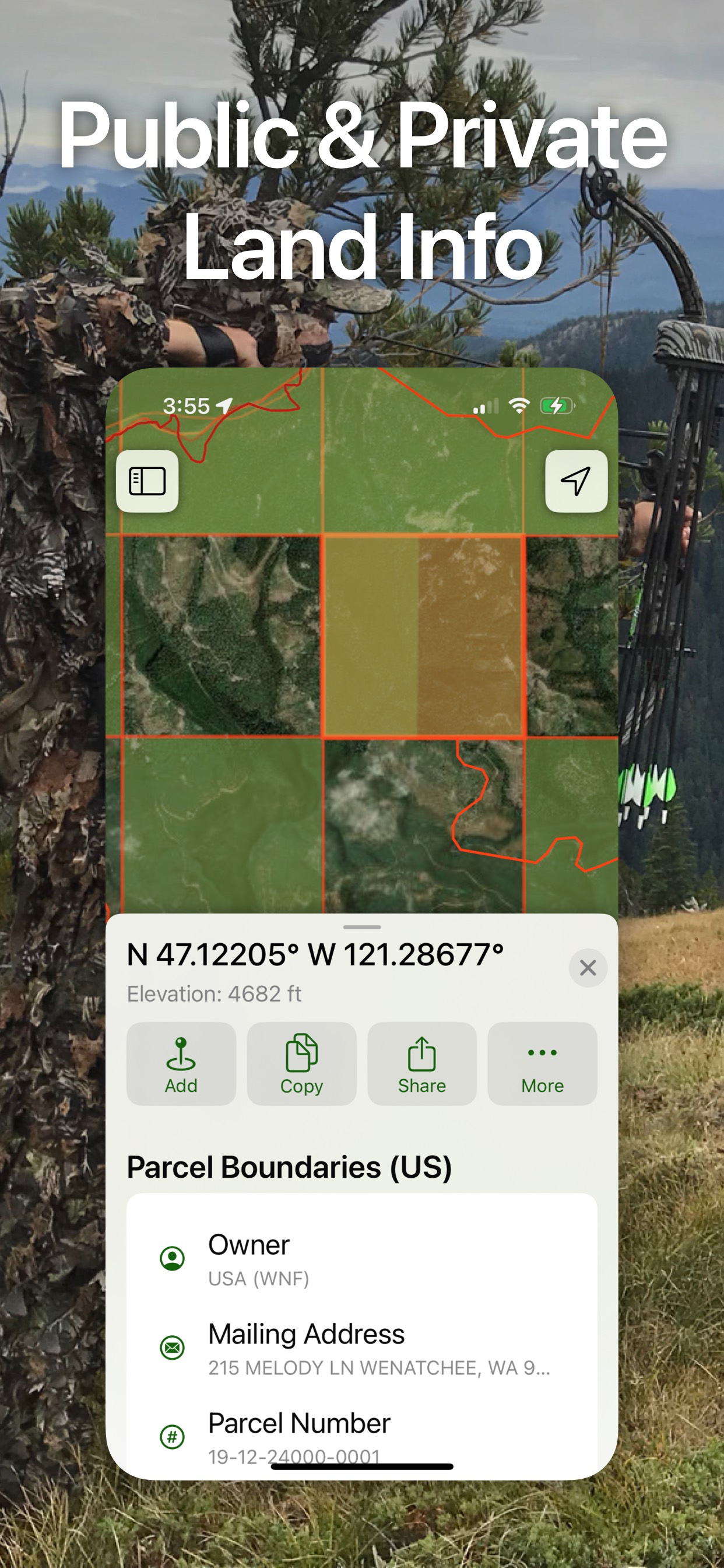
‣‣ TRUSTWORTHY MAPS
Worldwide backcountry maps such as Accuterra, Thunderforest, and New Zealand’s LINZ maps are just two of the high resolution maps available! Open Cycle, ESRI’s ArcGIS including Topo, Street, and Satellite maps are there as well!

Add definition to your maps with custom overlays like:
‣ Worldwide Elevation Heat map (color the map based on elevations)
‣ Hill Shading
‣Hybrid Maps - mix satellite and contour lines

‣‣ PLANNING TOOLS
‣ Compare and Download maps for use offline.
‣ Combine overlays to customise your map view
‣ Smart route-building tools
‣ Unlimited waypoints
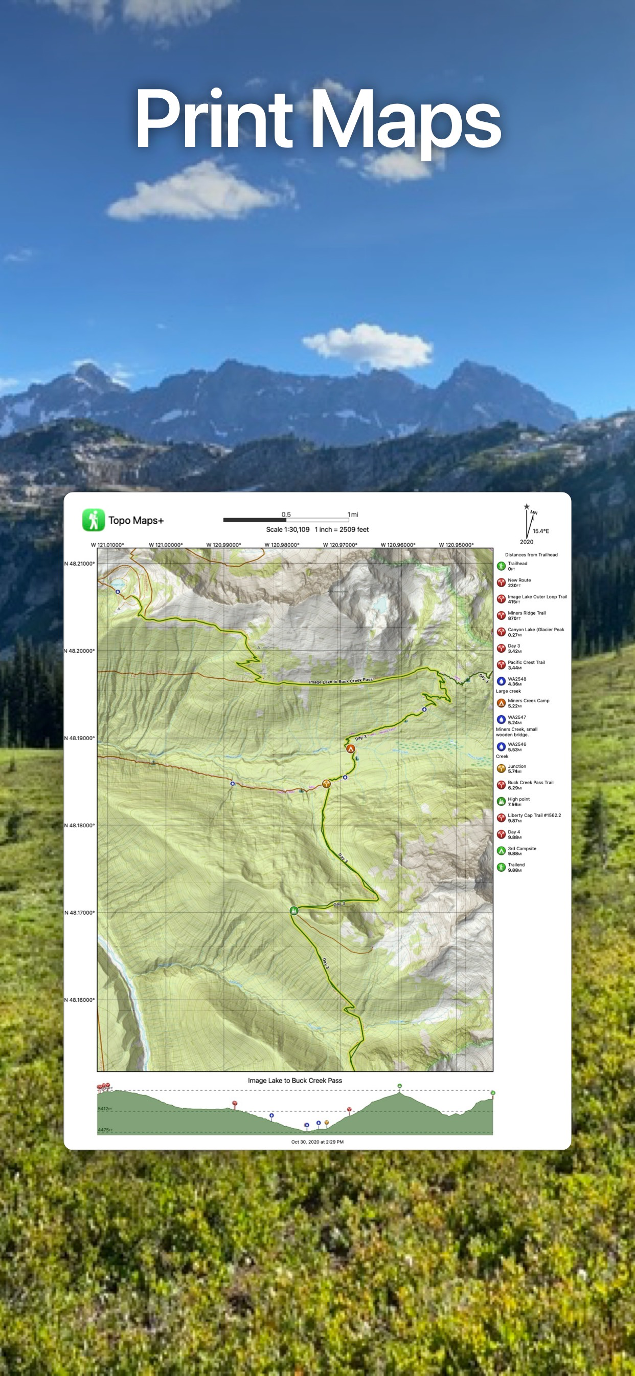
Print, email or share custom maps and routes

‣‣ ON-TRAIL TOOLS (Offline)
‣ View your current location
‣ Record your tracks
‣ Proximity Alerts - notify me when I’m close to a waypoint, trail, or region
‣ Line of Sight - what am I looking at?
‣ Progress on Trail - how much further on the trail
‣ Guide Me to a waypoint
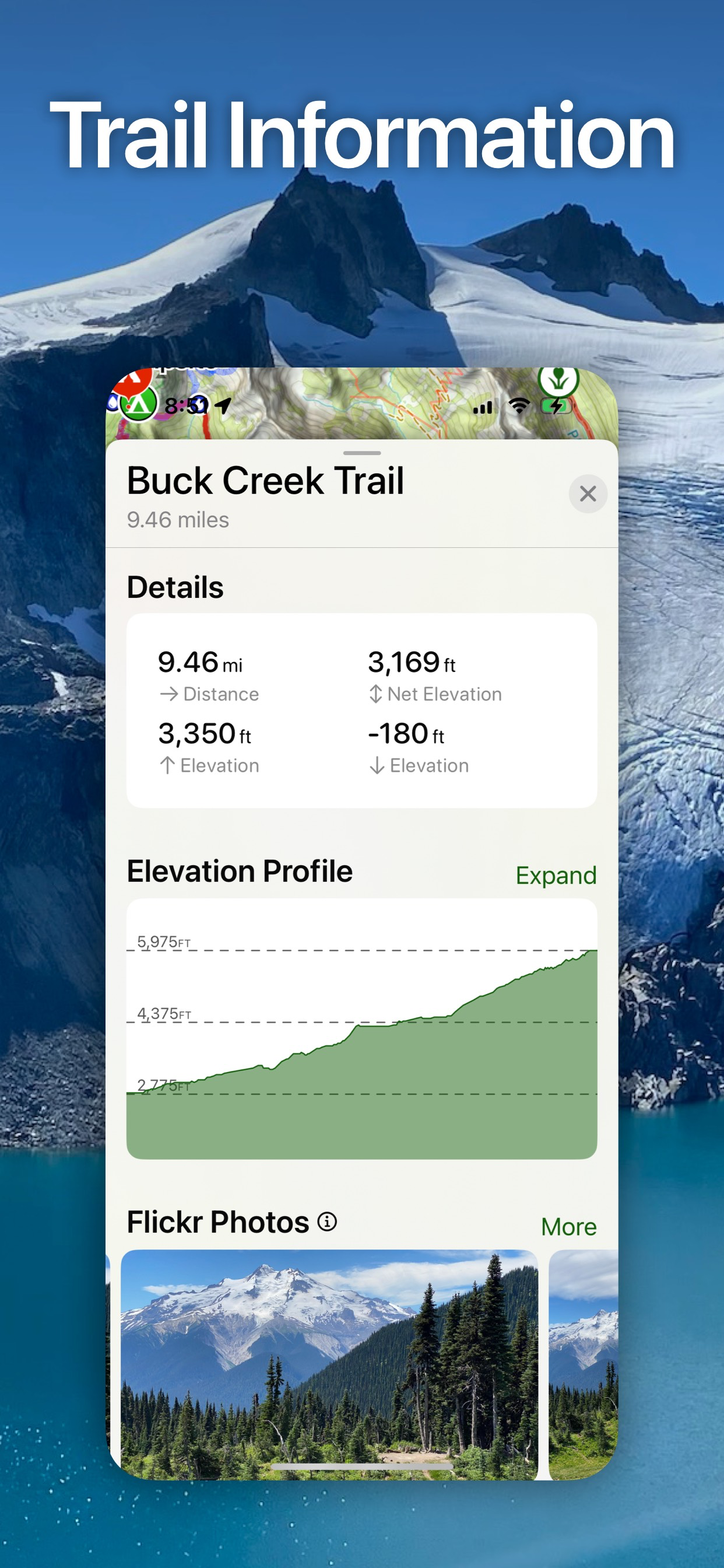
‣ Downloaded elevation data for route-creation on the trail
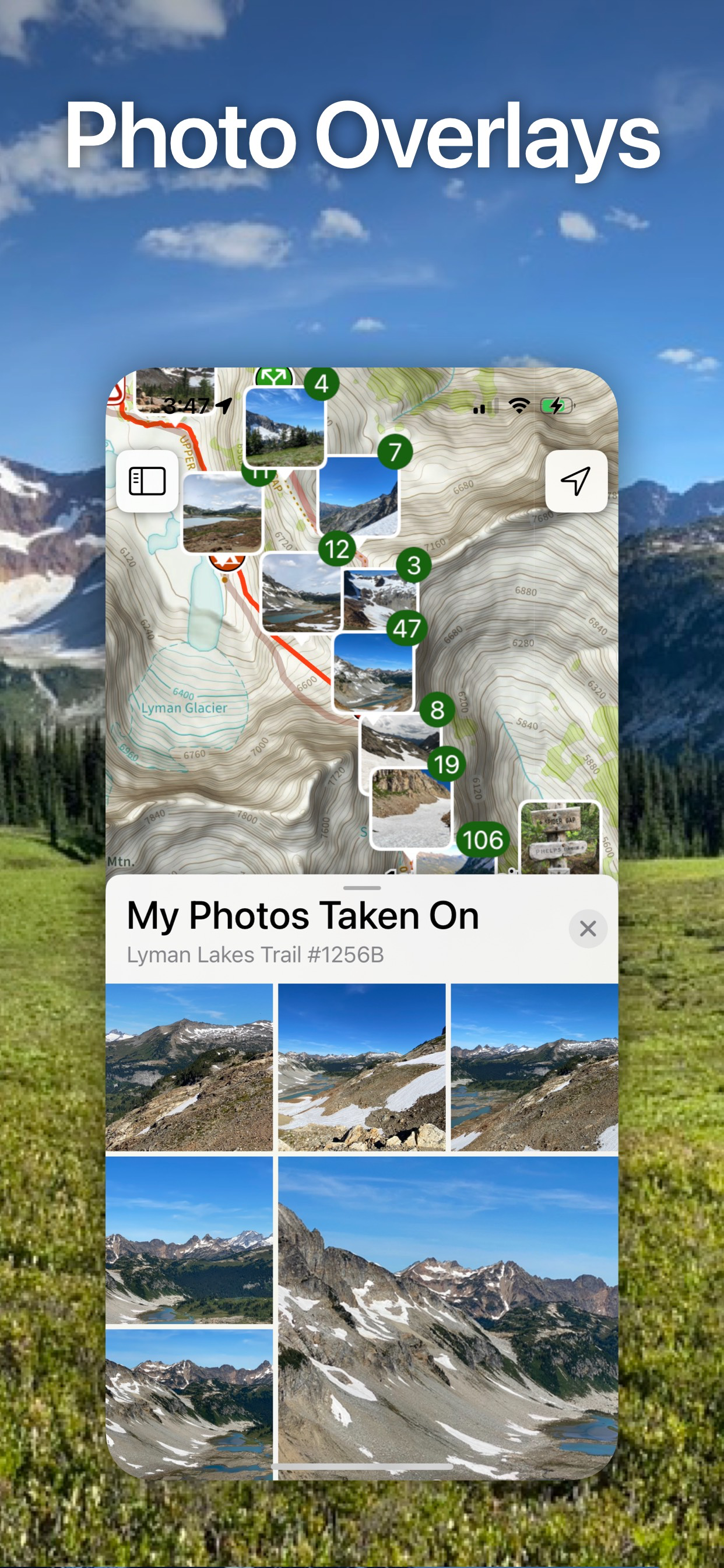
Photo Waypoints - snap a pic and instantly shows on the map

‣‣ NAVIGATIONAL MINDSET - helpful tips and tricks for keeping you safe in the backcountry!

SUBSCRIPTION LEVELS:
FREE level: view low resolution maps, record your tracks, and limited features
FREE all access 7- day trial of all features and maps.

Topo Maps+ Pro: high resolution maps, download maps, planning & on-trail tools, driving mode, import geospatial PDFs and TIFFS
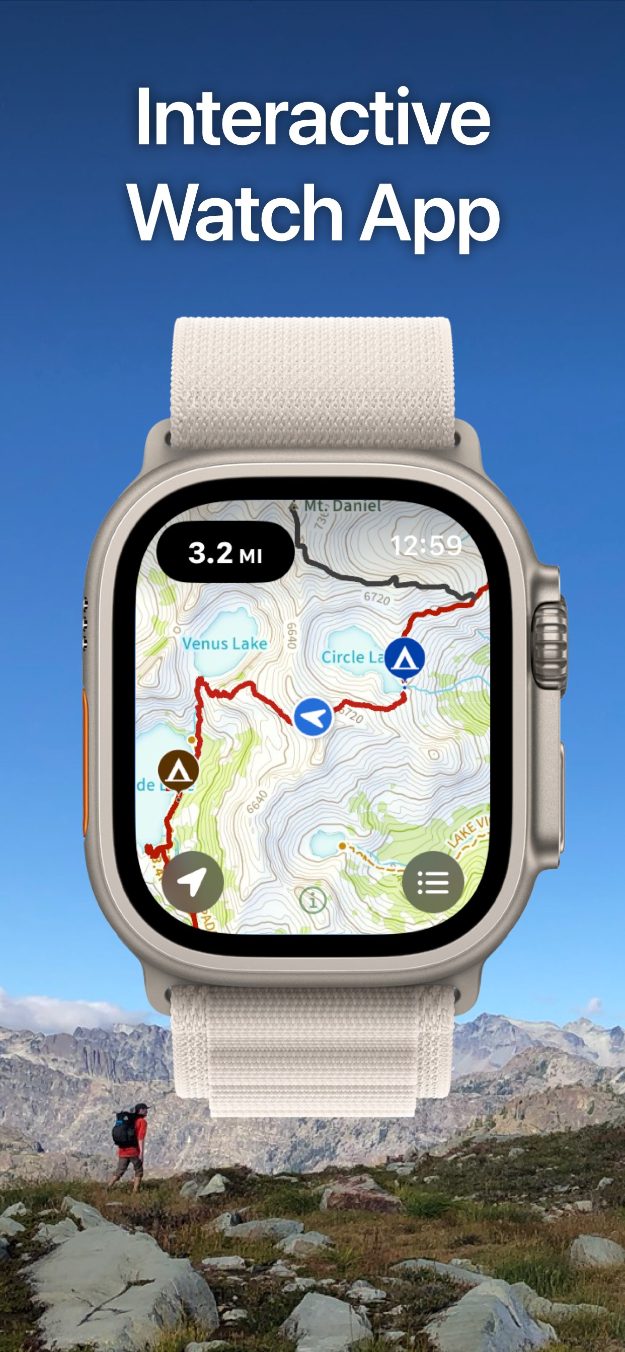
APPLE WATCH
View your offline maps and current location just by glancing down at your wrist.
CLOUD
Sync your routes, trips, subscriptions, and waypoints between all of your iOS and Mac devices.

SUBSCRIPTION PAYMENT INFORMATION
Topo Maps+ subscriptions will be charged to your Apple ID account at the confirmation of purchase. Subscription automatically renews unless it is canceled at least 24 hours before the end of the free trial or current period. Your account will be charged for renewal within 24 hours prior to the end of the current period. You can manage and cancel your subscriptions by going to your account settings on the App Store after purchase.
Privacy Policy: https://glacierpeak.app/privacy.html
Terms of Service: https://glacierpeak.app/tos.html
Continued use of GPS running in the background can dramatically decrease battery life.
Hide.. Show more..

In-Apps

Topo Maps+
$0.00
12 Months PRO
$99.99
Topo Maps+ Pro
$81.99
3 Month Map Pass
$19.99
6 Month Map Pass
$22.99
Topo Maps+ Elite
$114.99
12 Month Map Pass
$29.99
Topo Maps+ Essentials
$39.99
Topo Maps+ Pro: 3 Months
$40.99
Topo Maps+ Essentials 3 Months
$22.99

Screenshots

User Rating

4.61 out of 5

185 ratings in Australia

5 star
135
4 star
38
3 star
7
2 star
0
1 star
5

Ratings History

Reviews

Not enough of Aus

GruntyG on

It looks like a really solid tool for people who live in USA, Canada and NZ; but if you want to use it outside of those countries you’re stuck with the world map. Unfortunately there just is not enough landmarks and features on the world map to make it a reliable navigational aid. I’ll happily revisit this review if the developer can partner with an Australian map provider.

Doesn’t cut it for serious back country

adventuresofcaro on

Ive tried and tried with this app. Excessive battery use Errors is renewing map passes Tracking drop outs when it matters Poor map coverage for places that are not the usa. Basically if you are serious about safety in tracking back country in all conditions, try something else.

So convenient it’s ridiculous

Agentcombat on

I started using this app in Australia and I was sceptical about what I’d experience. I’ve been using it for almost a year now I’m really remote areas and I’m finding trails everywhere as soon as I hit regular hiking areas. I’ve also realised more recently that it has a whole bunch of features I didn’t notice at first like the ability to geo-tag photos and record trail progress. I now use it when I’m trailrunning to track elevation, speed and progress at the same time as checking I’m heading in the right direction. Naming and saving trails is also easy and quick. Just make sure you download all the maps of the area you are on your way to visit BEFORE you get there so that once you lose phone reception and the satellites kick in, you’ll have detailed maps for reference. 😉

Subscription?

Mvyrmnd on

Why can’t I have a perpetual licence? Why don’t you have a perpetual licence so I don’t have to pay every year to cache some maps?

Trail over a cliff?

Kubrickau on

This App saved the day. A while back, hiking in fresh snow, I was following cairns and found myself at the top of a cliff. Not a person within 100 kilometres. Looking back and trying to discover where I went wrong I realised I was not going to find the buried trail. Then I remembered I had loaded this App in my phone. No service there but the maps were all there and the GPS placed me on the map. As I zoomed in I found the trail I was hiking. That was unexpected as it was a rather esoteric trail that not many know about. I was able to immediately find my way back to the trail and relied on the App, rather than the cairns, for the rest of the trip. Thanks!

New trail maker

Whatarat on

I have been using topo maps for about 8-9 mths now and it has been an excellent land navigation tool and a very ease app to play with. I am a member of the Phuket HHH and this is reflected in my nickname. I love walking and running and especially finding new exciting places for my running club to explore. I am one of many who set the trails for others to follow. Topo maps has made my work in the field and back on the desktop so much easier. I plan to use for many years to come and look forward to more great ideas and upgrades. Thanks topo maps, its awsome. Just an update. I am a regular user of this awsome app and each time I use it I find new ways to make my hiking experience better. Keep the good trails coming

Excellent

Adventurer+ on

Great App

Very disappointing

Pete Tarca on

To those thinking about this app option: Don't spend your money here. Just do the free version if you must. 1. I Paid for High Resolution... & got nothing different. 2. Maps take waaaaay toooo long to load (you don't want to wait 2 minutes just for a single view to load do you?) My connection is plenty fast enuff - maybe there's a server problem?. To the developers of this app: you have got to lift your speeds and map detail quality.

Store Rankings

Ranking History

Category Rankings

Chart
Category
Rank
Top Grossing
42
Top Grossing
45
Top Grossing
46
Top Grossing
48
Top Free
49

Keywords

Users may also like

Name
Guru Maps - Offline Navigation
Route Planner, Offroad Trails
Commander Compass Go
Compass, GPS & Offline Maps
Avenza Maps: Offline Mapping
GPS, Trails, Hiking, Offroad
GPS Tracks
GPS Tracker and Offline Maps
Topo GPS - Topographic maps
Topographic maps
FarOut Guides
GPS Maps: Hiking Biking Paddle
Compass 55. Map & GPS kit.
Land, air, marine navigation
Gaia GPS: Mobile Trail Maps
Hiking, Overlanding, Camping
CalTopo
Backcountry mapping evolved
Topo Maps US
Show More

Revenue and Downloads

Gain valuable insights into Topo Maps+ performance with our analytics. Sign up now to access downloads, revenue, and more.

App Info

Category
Navigation
Languages
English, French, German, Italian, Japanese, Russian, Chinese
Recent version
8.1.1 (5 days ago )
Released on
Jul 30, 2013 (10 years ago )
Last updated
2 days ago