
Map Data Explorer
#1 Keyword Rankings
Today
Top 10 Rankings
Today
Top 30 Rankings
Today
Top 100 Rankings
Today
Description
Map Data Explorer is a advanced mapping app powered by vector tile basemaps (TMG OSM vector tiles, MapBox and others) with configurable stylesheets
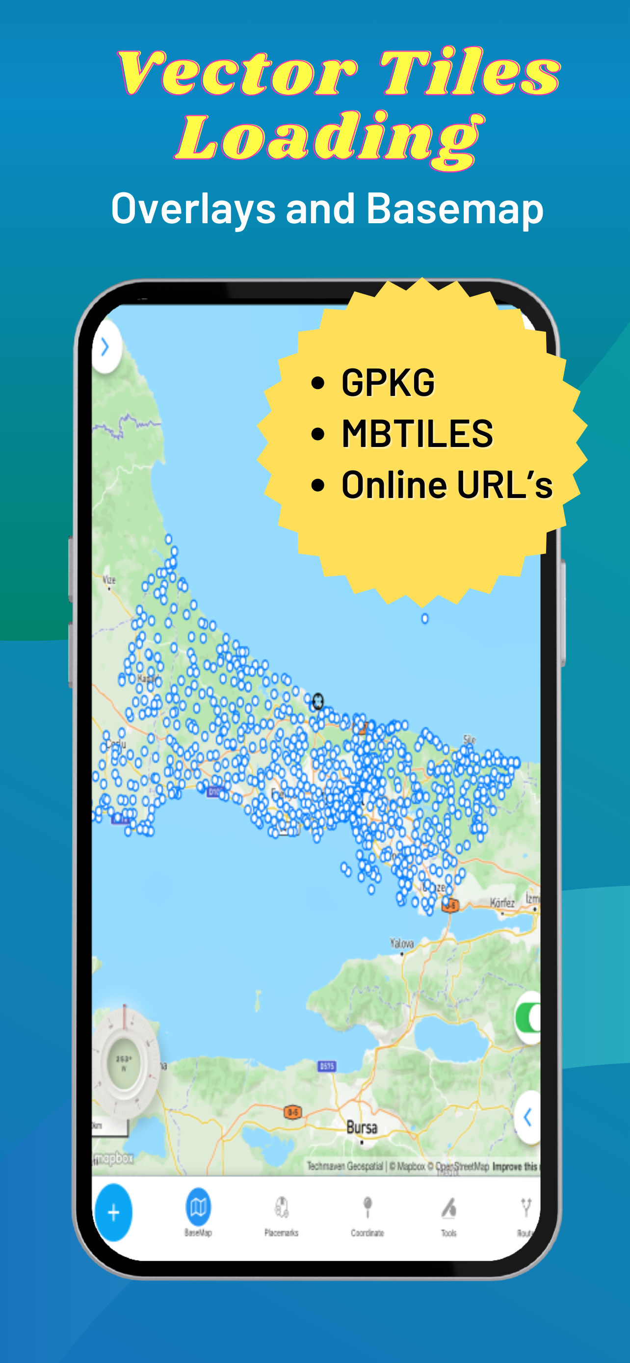
Supports user loaded device GeoJSON,Raster tiles from MBTILES and GPKG and vector tiles from MBTILES.
Supports user loaded Map Catalog (JSON) of internet mapping content (with catalog building screen)
XYZ PNG/JPG Raster Tiles
PBF Vector Tiles
GeoJSON
Local map tiles in mbtiles and gpkg
Includes additional layers users can enable:
vector overlays (Reference Grids, TimeZones and US State Boundaries)
Draw/digitize vector data and support editing and assigning attributes.
Map Supports Tilting to display 3D terrain and 3D Buildings (only some basemaps support 3D buildings )
Currently, terrain is not available offline.
Map Tools:
- Search - places, addresses
- Advanced dynamic data collection forms with form builder
- Draw/Digitize Data Creation and Editing and export as GeoJSON
- Information Box for geojson data
- Measure linear and Area
- Geolocation & Coordinate Widget (Lat Long and MGRS and zoom level) and share location
- Go to Lat Long
- Placemarks (spatial bookmarks) (with import and export of Waypoints GeoJSON, KML and GPX)
- Basic Route Planning with import of Waypoints (KML and GPX)
- Connection to other Navigation Apps
- GPS Recorder with background recording and export or track
- View Spot Elevation
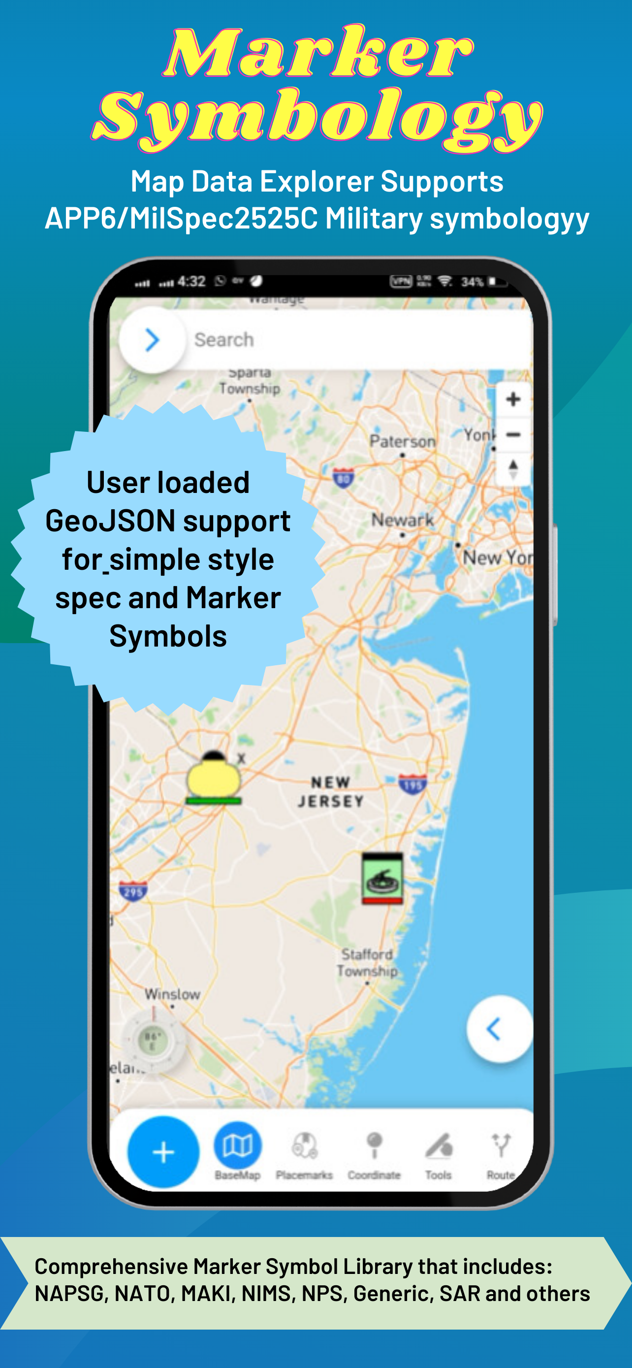
- Display Military Symbology (App6/MilSpec2525C) GeoJSON Schema easily shared with other apps
- Radius Ruler/Range Rings
- Coordinate Converter (to/from projected coordinates or geographic and GRIDS - MGRS, GARS, WHAT3WORD)
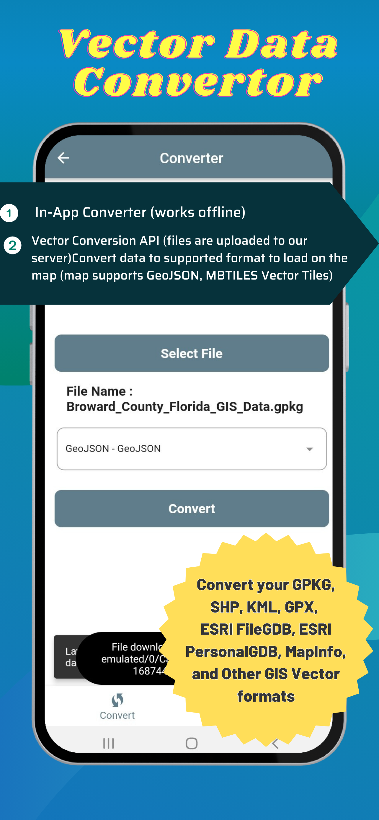
Includes an in-app vector converter to convert GIS data (Shapefiles, GPKG, GPX, KML, CSV, WKT to GeoJSON) must be 4326
Includes in-app coordinate converter to convert to /from different coordinate systems and GRIDS (MGRS,GARS, etc)
Wifi Sharing - access device files from web browser
File Manager To manage files
Create Forms with in-app or web form designer with JSON Schema
Load a form design and swap between forms
Collect any form data
Other features:
Vector Conversion and Publishing API to convert local vector GIS Data and also publish to PostGIS database tables.
Added Button links to TMG Map Data Explorer website for all in-app purchase screen
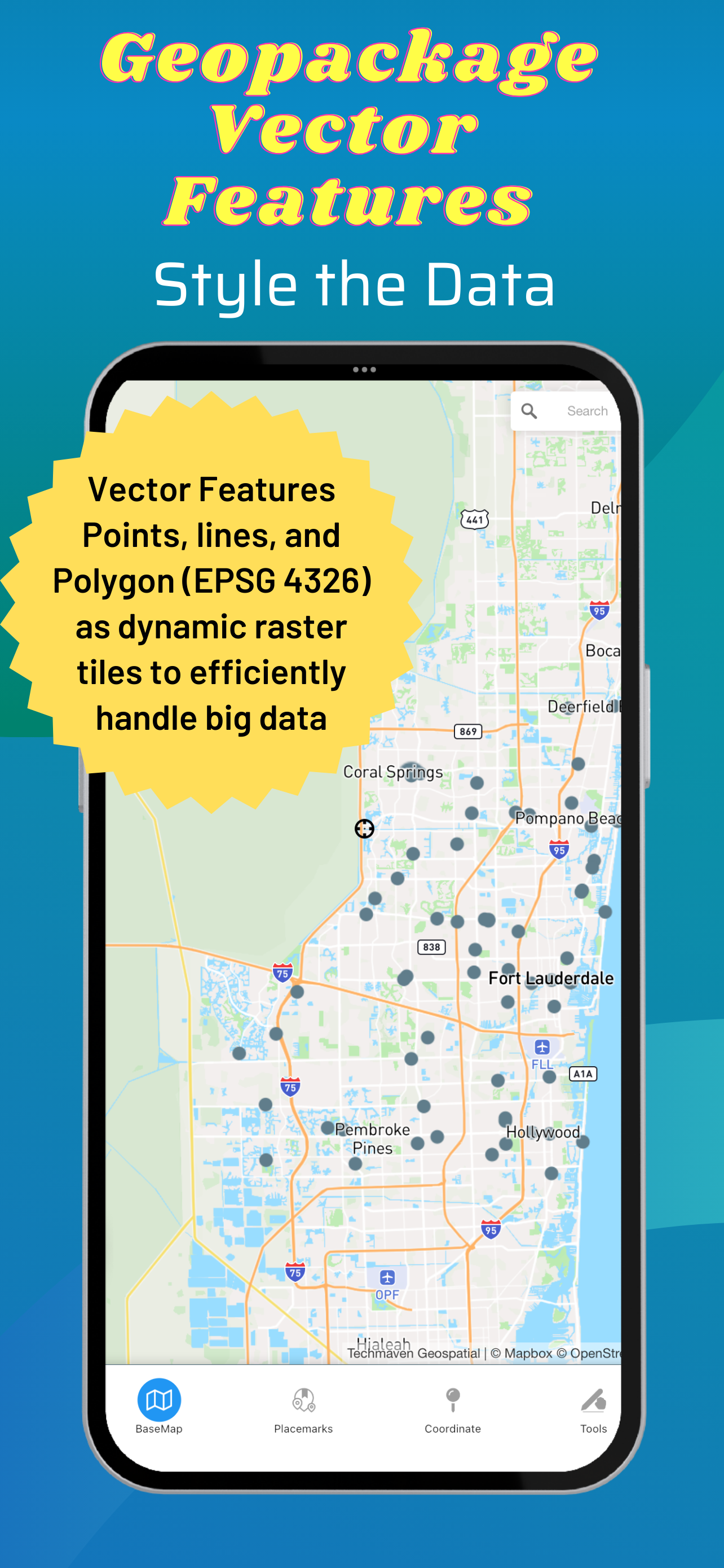
Serve OGC GPKG -GeoPackage with Vector Tiles new OGC extensions
Support for any SRS for raster tiles in GPKG (tested with 3857 and 3395)
Support for any SRS for Vector Tiles in GPKG (tested with 3857 and 3395)
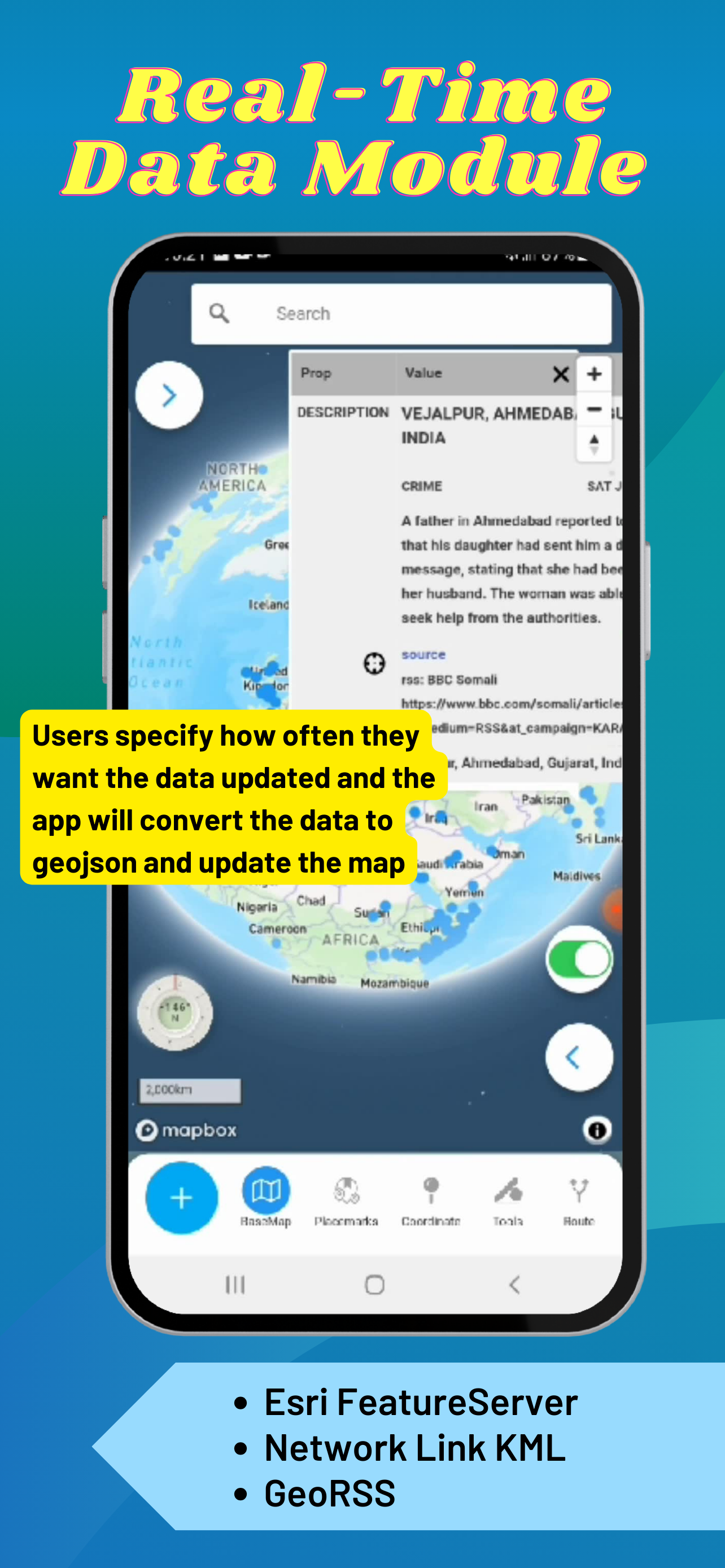
Real-Time Data Module (Network Link KML and Internet KML, ESRI GeoServices REST API and GeoRSS) display on the map and update at set frequency
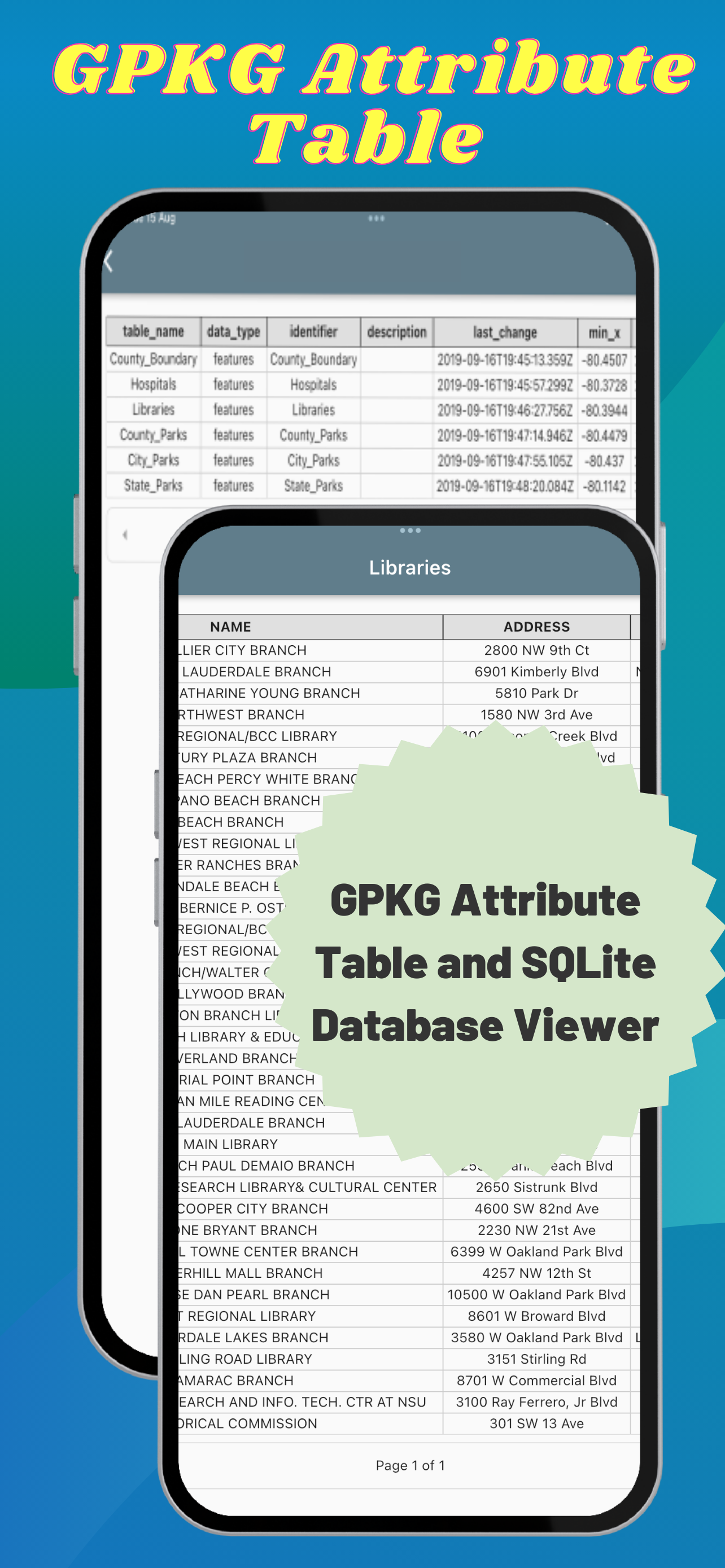
Button to view attributes from GPKG Vector Features
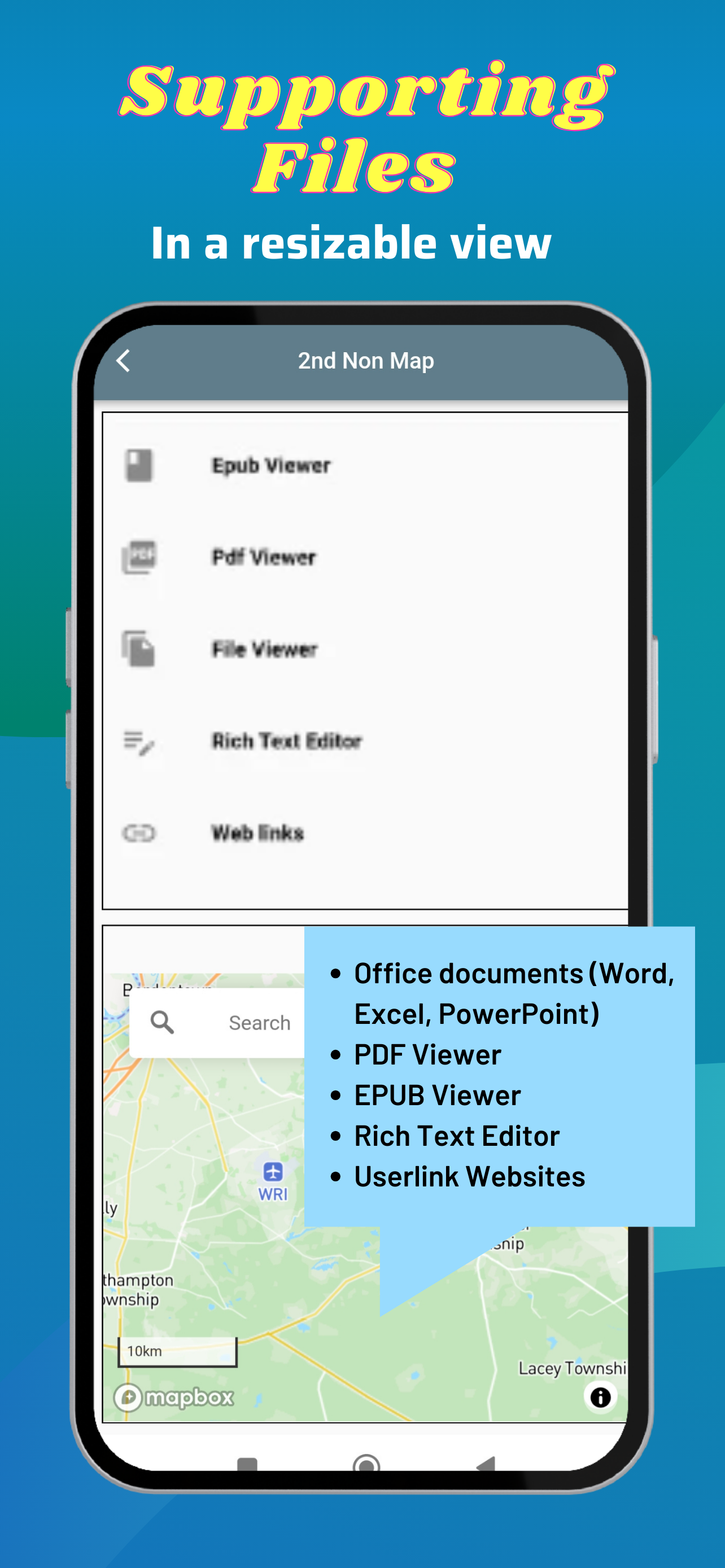
2nd Non Map View – Office documents (Word, Excel, Powerpoint), PDF Viewer, EPUB Viewer, User links web pages and File Manager
User loaded GeoJSON support for simple style spec and Marker Symbols
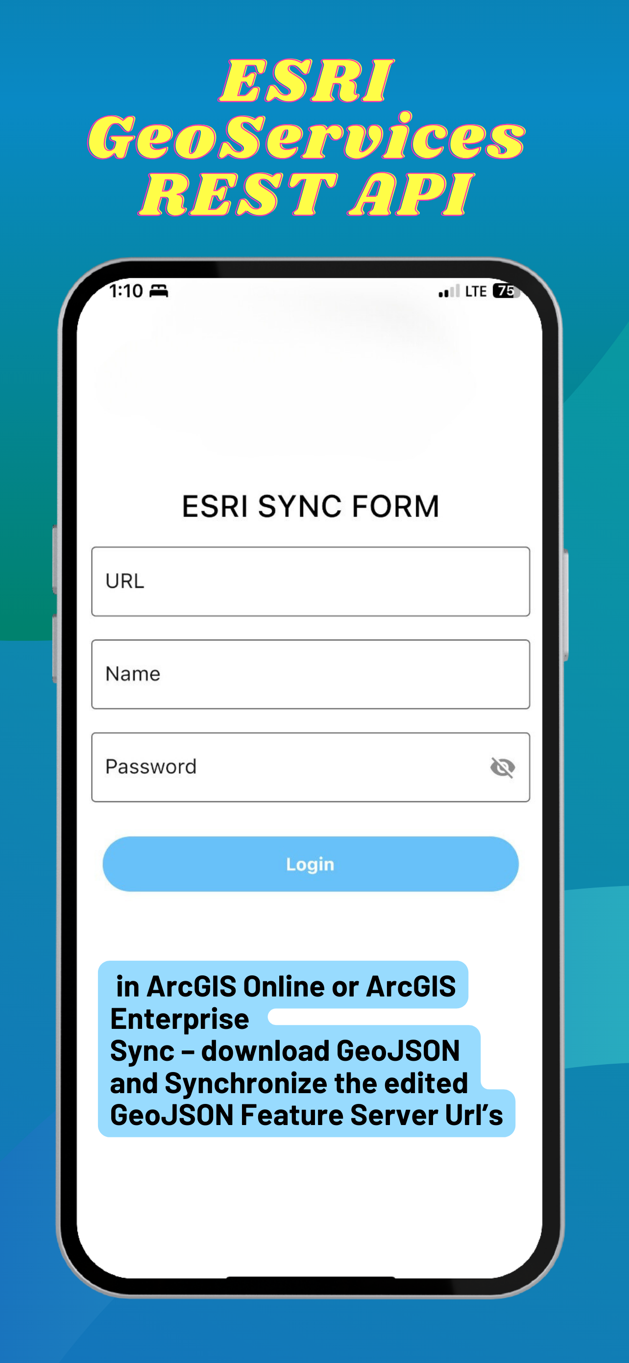
ESRI GeoServices REST API (FeatureServer) in ArcGIS Online or ArcGIS Enterprise Sync – download GeoJSON and Synchronize edited GeoJSON.
Elevate API - submit geojson point and return back with Elevation, MGRS, GARS, What3Words, PlaceKey, Pluscode properties
GeoRequest Area of Interest API for submitting jobs for offline data
Pre-staged data downloading of ready to download data
Area of interest downloading of online map data:
Tile Downloader that supports building mbtiles from tile layers (XYZ/TMS, WMTS and Dynamic and cached mapping services (ESRI MapServer, ImageServer, OGC WMS) and downloading GeoJSON from WFS and MapServer and FeatureServer.
Terms of Use: https://mapexplorer.techmaven.net/eula/
Hide..
Show more..
Supports user loaded device GeoJSON,Raster tiles from MBTILES and GPKG and vector tiles from MBTILES.
Supports user loaded Map Catalog (JSON) of internet mapping content (with catalog building screen)
XYZ PNG/JPG Raster Tiles
PBF Vector Tiles
GeoJSON
Local map tiles in mbtiles and gpkg
Includes additional layers users can enable:
vector overlays (Reference Grids, TimeZones and US State Boundaries)
Draw/digitize vector data and support editing and assigning attributes.
Map Supports Tilting to display 3D terrain and 3D Buildings (only some basemaps support 3D buildings )
Currently, terrain is not available offline.
Map Tools:
- Search - places, addresses
- Advanced dynamic data collection forms with form builder
- Draw/Digitize Data Creation and Editing and export as GeoJSON
- Information Box for geojson data
- Measure linear and Area
- Geolocation & Coordinate Widget (Lat Long and MGRS and zoom level) and share location
- Go to Lat Long
- Placemarks (spatial bookmarks) (with import and export of Waypoints GeoJSON, KML and GPX)
- Basic Route Planning with import of Waypoints (KML and GPX)
- Connection to other Navigation Apps
- GPS Recorder with background recording and export or track
- View Spot Elevation
- Display Military Symbology (App6/MilSpec2525C) GeoJSON Schema easily shared with other apps
- Radius Ruler/Range Rings
- Coordinate Converter (to/from projected coordinates or geographic and GRIDS - MGRS, GARS, WHAT3WORD)
Includes an in-app vector converter to convert GIS data (Shapefiles, GPKG, GPX, KML, CSV, WKT to GeoJSON) must be 4326
Includes in-app coordinate converter to convert to /from different coordinate systems and GRIDS (MGRS,GARS, etc)
Wifi Sharing - access device files from web browser
File Manager To manage files
Create Forms with in-app or web form designer with JSON Schema
Load a form design and swap between forms
Collect any form data
Other features:
Vector Conversion and Publishing API to convert local vector GIS Data and also publish to PostGIS database tables.
Added Button links to TMG Map Data Explorer website for all in-app purchase screen
Serve OGC GPKG -GeoPackage with Vector Tiles new OGC extensions
Support for any SRS for raster tiles in GPKG (tested with 3857 and 3395)
Support for any SRS for Vector Tiles in GPKG (tested with 3857 and 3395)
Real-Time Data Module (Network Link KML and Internet KML, ESRI GeoServices REST API and GeoRSS) display on the map and update at set frequency
Button to view attributes from GPKG Vector Features
2nd Non Map View – Office documents (Word, Excel, Powerpoint), PDF Viewer, EPUB Viewer, User links web pages and File Manager
User loaded GeoJSON support for simple style spec and Marker Symbols
ESRI GeoServices REST API (FeatureServer) in ArcGIS Online or ArcGIS Enterprise Sync – download GeoJSON and Synchronize edited GeoJSON.
Elevate API - submit geojson point and return back with Elevation, MGRS, GARS, What3Words, PlaceKey, Pluscode properties
GeoRequest Area of Interest API for submitting jobs for offline data
Pre-staged data downloading of ready to download data
Area of interest downloading of online map data:
Tile Downloader that supports building mbtiles from tile layers (XYZ/TMS, WMTS and Dynamic and cached mapping services (ESRI MapServer, ImageServer, OGC WMS) and downloading GeoJSON from WFS and MapServer and FeatureServer.
Terms of Use: https://mapexplorer.techmaven.net/eula/
In-Apps
- TMG Elevate API
- S$ 7.48
- Tile Downloader Module
- S$ 6.98
- TMG Vector Conversion API
- S$ 21.98
- Pre-Staged Data Downloading
- S$ 299.98
- GeoRequest Area of Interest
- S$ 148.98
- Map Data Explorer Subscription
- S$ 6.98
- MapBox RGB PNG Elevation Tiles
- S$ 36.98
Screenshots


 User Rating
0 out of 5
0 ratings in Singapore
Ratings History
Reviews
App doesn't have any reviews yet
Store Rankings
Ranking History
App Ranking History not available yet
Category Rankings
|
Chart
|
Category
|
Rank
|
|---|---|---|
|
Top Free
|

|
447
|
Keywords
Users may also like
| Name | Reviews | Recent release | |
|---|---|---|---|

Route3D 3.0
Topo map navigation
|
0
|
1 year ago | |

Map Stretch
|
0
|
1 year ago | |

Lim Geomatics Prism
|
0
|
1 month ago | |

CartoLake - Map Studio
Map Viewer and Authoring Tool
|
0
|
1 year ago | |

Flight LTE
|
0
|
1 year ago | |

Walkr Hike Overlay
|
0
|
1 year ago | |

OsmoTagger
OpenStreetMap editor
|
0
|
2 months ago | |

GPXLAB
GPS Track Editor
|
0
|
7 months ago | |

eLiteMap
Offline maps & data collection
|
0
|
2 months ago | |

3D Mappa - GIS & Contour Maps
|
0
|
1 month ago |
Show More
Revenue and Downloads
Gain valuable insights into Map Data Explorer performance with our analytics. Sign up now
to
access downloads, revenue, and more.
App Info
- Category
- Navigation
- Publisher
- Tech Maven Geospatial, LLC
- Languages
- English
- Recent version
- 1.4 (1 month ago )
- Released on
- Oct 31, 2022 (1 year ago )
- Also available in
- Poland, India, United Arab Emirates, Japan, Kuwait, Kazakhstan, Lebanon, Mexico, Netherlands, Norway, Peru, Philippines, Pakistan, Italy, Romania, Russia, Saudi Arabia, Sweden, Singapore, Thailand, Turkey, Taiwan, Ukraine, United States, Vietnam, South Africa, Dominican Republic, Argentina, Austria, Australia, Brazil, Belarus, Canada, Switzerland, China, Colombia, Czechia, Germany, Denmark, Israel, Algeria, Ecuador, Egypt, Finland, France, United Kingdom, Hong Kong, Hungary, Indonesia, Portugal, Nigeria, Malaysia, Greece, Ireland
- Last updated
- 3 weeks ago