Description
Plan orienteering events by placing and fine tuning control locations in the field.
Create your own instant offline maps.
Create geolocated maps from photos and pictures, either with your own photos of maps, or with maps imported from elsewhere.
Open geolocated KMZ map images created by Map Snapper or other programs. Just copy it to Map Snapper.
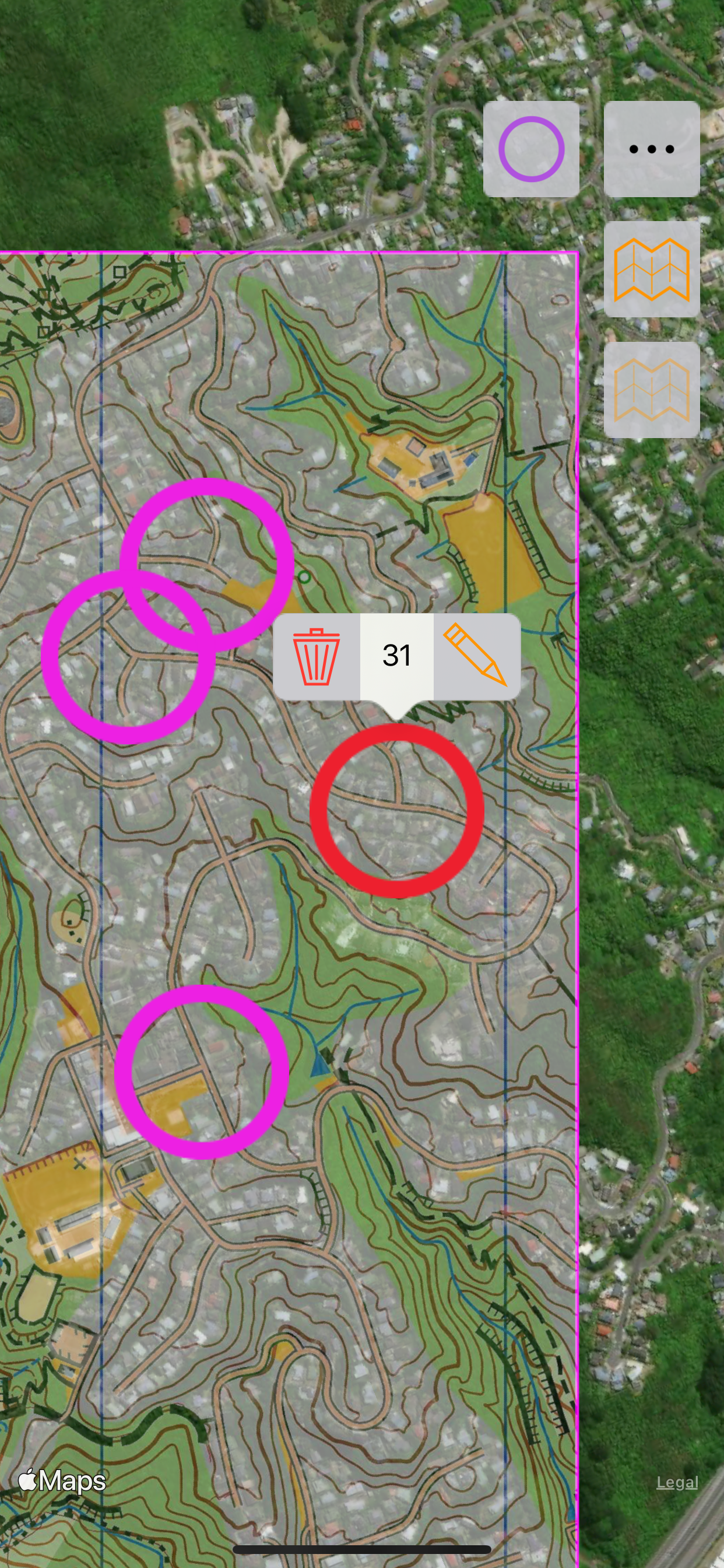
Import Controls (placemarks) from KMZ, KML and IOF XML files, as well as create your own.
Check your control placement against the map, and satellite images. Fine tune the control locations while in the field.
Export your controls to KML files. Either export all controls, or create a MapRun compatible file with S1, numbered controls and F1 (if no F1, S1 location will be used for finish).
Export your controls to a Condes compatible file, then import to Condes to update the control locations.
Import Courses from IOF XML files, or create your own. These are simply a list of control codes in order and are used to create MapRun compatible KML files. Hubs are supported by repeating the control code for the hub for subsequent visits.
Map Snapper Pro (optional In-App Purchase)
With Map Snapper Pro, you can export your map with embedded location data as JPG or KMZ.
Map Snapper Pro also allows you to open multiple maps at once.
How to Geolocate a Map:
1. Take a photo of the map (or copy a picture to Map Snapper).
2. Choose an obvious location on your photo, and line up the purple crosshairs.
3. Find the same location on the map, and line up the purple crosshairs on the map.
4. Press the Purple crosshair button to lock this location.
5. Repeat for another location with the blue crosshairs.
6. Check your alignment, and use your map.
Note: Most maps on information boards are accurate enough for this simple alignment method to work - they just have to be drawn to scale.
How to work with Condes
https://condes.net (c) Finn Arildsen Software (not affiliated with Map Snapper):
1. From Condes, Export a KMZ or Bitmap Image as JPG.
2. Copy map (KMZ or JPG) to Map Snapper.
3. For JPG, geolocate the Map as described above.
4. Optional: export IOF XML Event Data with controls and send to Map Snapper.
5. Edit and add controls in Map Snapper as desired.
6. From Map Snapper, Export the Controls to Condes File.
7. Import the Controls into Condes, overwriting controls that have moved.
Note: Map Snapper defaults the Condes map location bottom left corner to (0,0).
In Condes, Either:
1. Make sure print area is at (0,0) - adjust the canvas map details East & North if not.
2. Or, for a geolocated map, export IOF XML Event Data with at least 2 Controls, send to Map Snapper, and update the map location.
Hide..
Show more..
Create your own instant offline maps.
Create geolocated maps from photos and pictures, either with your own photos of maps, or with maps imported from elsewhere.
Open geolocated KMZ map images created by Map Snapper or other programs. Just copy it to Map Snapper.
Import Controls (placemarks) from KMZ, KML and IOF XML files, as well as create your own.
Check your control placement against the map, and satellite images. Fine tune the control locations while in the field.
Export your controls to KML files. Either export all controls, or create a MapRun compatible file with S1, numbered controls and F1 (if no F1, S1 location will be used for finish).
Export your controls to a Condes compatible file, then import to Condes to update the control locations.
Import Courses from IOF XML files, or create your own. These are simply a list of control codes in order and are used to create MapRun compatible KML files. Hubs are supported by repeating the control code for the hub for subsequent visits.
Map Snapper Pro (optional In-App Purchase)
With Map Snapper Pro, you can export your map with embedded location data as JPG or KMZ.
Map Snapper Pro also allows you to open multiple maps at once.
How to Geolocate a Map:
1. Take a photo of the map (or copy a picture to Map Snapper).
2. Choose an obvious location on your photo, and line up the purple crosshairs.
3. Find the same location on the map, and line up the purple crosshairs on the map.
4. Press the Purple crosshair button to lock this location.
5. Repeat for another location with the blue crosshairs.
6. Check your alignment, and use your map.
Note: Most maps on information boards are accurate enough for this simple alignment method to work - they just have to be drawn to scale.
How to work with Condes
https://condes.net (c) Finn Arildsen Software (not affiliated with Map Snapper):
1. From Condes, Export a KMZ or Bitmap Image as JPG.
2. Copy map (KMZ or JPG) to Map Snapper.
3. For JPG, geolocate the Map as described above.
4. Optional: export IOF XML Event Data with controls and send to Map Snapper.
5. Edit and add controls in Map Snapper as desired.
6. From Map Snapper, Export the Controls to Condes File.
7. Import the Controls into Condes, overwriting controls that have moved.
Note: Map Snapper defaults the Condes map location bottom left corner to (0,0).
In Condes, Either:
1. Make sure print area is at (0,0) - adjust the canvas map details East & North if not.
2. Or, for a geolocated map, export IOF XML Event Data with at least 2 Controls, send to Map Snapper, and update the map location.
In-Apps
- Map Snapper Pro
- S/ 2.90
Screenshots


User Rating
App is not rated in Peru yet.
Ratings History
Map Snapper Installs
Last 30 days
Map Snapper Revenue
Last 30 daysMap Snapper Reviews
Store Rankings
Ranking History
App Ranking History not available yet
Category Rankings
|
Chart
|
Category
|
Rank
|
|---|---|---|
|
Top Free
|

|
125
|
Keywords
Map Snapper Competitors
| Name | Reviews | Recent release | |
|---|---|---|---|
GPS Trail Map
Add GPS to any Trail Map
|
0
|
1 year ago | |

MMV Les vacances Club
|
0
|
4 months ago | |

NaVida
Maps for and by enthusiasts
|
0
|
6 months ago | |

MyGIS
Your Navigation Companion
|
0
|
8 months ago | |
OkMap Mobile
Un navegador GPS off-road
|
0
|
1 month ago | |

Nomina Locum AR
Locate places next to you AR
|
0
|
1 day ago | |

Map Stretch
|
0
|
1 year ago | |

Compass - Maps
GPS Compass Navigator
|
0
|
1 year ago | |

GPS-Trk 3
Pro-grade Remote Realtime GPS
|
0
|
1 month ago | |

Terra Incógnita
|
0
|
1 year ago |
Map Snapper Revenue and Downloads
Gain valuable insights into Map Snapper performance with our analytics.
Sign up now to access downloads, revenue, and more.
Sign up now to access downloads, revenue, and more.
App Info
- Category
- Navigation
- Publisher
- Mark Malone
- Languages
- English
- Recent version
- 2.1 (4 years ago )
- Released on
- Dec 18, 2019 (4 years ago )
- Also available in
- United Kingdom, France, New Zealand, Pakistan, Japan, South Korea, Kuwait, Kazakhstan, Lebanon, Mexico, Malaysia, Nigeria, Netherlands, Norway, Peru, Philippines, India, Poland, Portugal, Romania, Russia, Saudi Arabia, Sweden, Singapore, Thailand, Turkey, Taiwan, Ukraine, United States, Vietnam, South Africa, Denmark, Argentina, Austria, Australia, Azerbaijan, Belgium, Brazil, Belarus, Canada, Switzerland, Chile, China, Colombia, Czechia, Germany, Italy, Dominican Republic, Algeria, Ecuador, Egypt, Spain, Finland, Greece, Hong Kong, Hungary, Indonesia, Ireland, Israel, United Arab Emirates
- Last updated
- 1 week ago