Maps 3D PRO - Outdoor GPS
GPS for Bike, Hike & Ski
#1 Keyword Rankings
Today
Top 10 Rankings
Today
Top 30 Rankings
Today
Top 100 Rankings
Today

Description

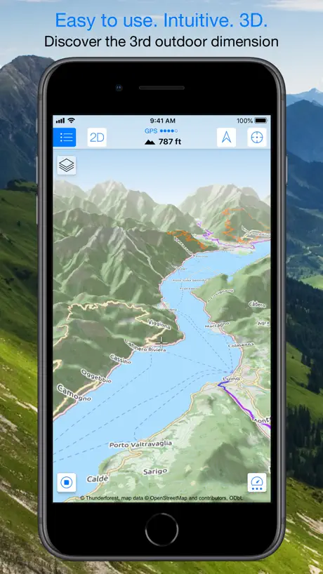
Enjoy exploring the great outdoors? If you’re a fan of biking, hiking and running then Maps 3D is the ideal app designed for planning your outdoor adventures. Whereas other mapping apps are primarily designed for cities and roads, displaying hills and mountains as flat and lifeless features, Maps 3D is packed with amazing features that brings the great outdoors to vibrant life with valleys, hills, mountains and footpaths displaying in full 3D so you’ll know your exact elevation.

*** Featured by Apple with a main banner in the US App Store Navigation category! (02/2013)
*** 3rd place at the '2013 Best App Ever Awards' by 148apps.com in 'Best Outdoors Apps'
*** Over 1,700,000 global users!
*** TOP 1 App in Navigation in 75+ countries (as of 01/2017)

*** "The functions are helpful; the compilation of 3D maps is impressive." Macwelt.de – Score: 1.8
*** "An app recommended for hikers, cyclists and horse enthusiasts..." iPhone & iPad apps in Test Magazine, issue 3/2011 – Score: 8/10


STORE ROUTES & USE OFFLINE

With Maps 3D you’ll have the option to plan, record and share your routes, turning your iPhone into a fully-fledged GPS device so you can log key coordinates and elevations. You’ll also have offline access to worldwide 3D map data which limits the drain on the battery and means that you can pre-load maps to store when you don’t have a signal.


SEARCHABLE MAPS

As an added bonus Maps 3D offers 3D terrain and trip planning, so you’ll never need to worry about getting lost. Towns, streets, mountain peaks and lakes are all searchable, with an accurate and precise map display based on NASA scans of the Earth’s surface combined with the outdoor map OSM (Open Street Map) and the Official USGS topo maps.


LOAD YOUR TRIPS & SHARE

GPX-tracks can be imported via iTunes, email, URL or Dropbox, and recorded tracks can be shared via email, Facebook and Twitter, great for showing your friends your latest outdoor accomplishments.


MORE FEATURES

+++ Load maps in advance over WIFI or 4G before your trek, no internet connection needed thereafter
+++ Record your routes by GPS, all coordinates and exact elevations are logged
+++ Plan and evaluate routes directly in the 3D map view
+++ Search for towns, streets , mountain peaks, lakes - offline
+++ Distance traveled, current and average speeds all displayed for an ideal trek


GENERAL / NOTES

Background GPS recording can significantly cut battery life


* * * * *
If you like Maps 3D, please remember to leave a positive rating on iTunes!

The movingworld team is working constantly to improve Maps 3D. Any suggestions? We'd love to hear them! Just e-mail them to us at [email protected]. We'll try to answer you within 24 hours!

Thank you for using Maps 3D!
Hide.. Show more..

In-Apps

Offline Routing
£3.99
Maps Plus Package
£12.99

Screenshots

User Rating

4.35 out of 5

43 ratings in United Kingdom

5 star
29
4 star
7
3 star
3
2 star
1
1 star
3

Ratings History

Reviews

Great App

VirtualMountains.co.uk on

An amazingly powerful app, and hats of to all involved. One request would be to improve the management of the downloaded maps; 1) Refresh - to reload the map with the latest tiles, 2) Unload - to keep the map name and area information but to delete the tiles and save space on the phone, 3) Reload - to reload an unloaded map.

Adequate

Glasserton459 on

Well defined routes and pretty accurate but the contours in 3D are sometimes well off the mark. Too many times it looks almost flat between two way points but in reality there can be hundreds of feet of difference. As for mapping out routes always add about 15-20% extra to the total, every time I’ve mapped out a route the final distance is always way more, no matter how accurate i try to be.

Only one thing missing…. Watch support

DonaldKiddick on

I’ve used this app for years. Provided me with memory of holiday trips, days out walks. Would It be possible to show coordinates, bearing and track offset on the Apple Watch?

3D maps for the 3D world we live in...

NWW6550 on

Discovering that these 3D maps existed was a revelation! See at a glance the terrain and having the ability to revolve your perspective around areas and features on the map is really useful.

Very good app

w@kille on

Not perfect but well worth the money. It allowed me to find the nearest hills to where I live in Oxfordshire, UK, which is all I wanted. The ability to increase the apparent gradient is an essential and well implemented feature.

Countryside Walks

Mrk48776 on

Fantastic for planning walks. Apple Watch integration works well.

Good app, but no version for the iPad

Draeysta on

Good app. I really like its 3D layout of maps, but unfortunately you can’t get a full screen version for the iPad even though I paid for it.

Terrible clunky app

Medion5019 on

This is one of the least intuitive apps I’ve ever used. The interface is clunky and tries to over complicate things when it would be better just sticking to being an offline open source map. Trying to find a location in somewhere like Canada is nearly impossible in the fly as place names only appear when you hover over the location for a while. Even on wifi half the maps don’t load fully. Waste of even the small amount of money it cost to get the ‘pro’ version, I won’t be trusting it on a hike.

Great app! Had no issues at all even at the top of Scarfell pike

jeremysmith69 on

This app successfully helped us navigate around the 5 highest peaks of the Lake District in severe rain fast winds and even worse visibility and the app still never dropped gps or bugged out, and barely uses any battery so thank you making a reliable easy to use and relatively cheap app!!

Not impressed by quality of the maps

nejad on

The design of the app and its interface is quite good but the maps are absolutely no match to the Ordinance Survey maps. Map colour is pale, tracks are barely visible and most of the place names are too small and to make the matter worse the more you zoom in, smaller they get! And for 3D view, I haven’t tried the app on mountains but on hills the 3D view of the app is just a useless gimmick

Store Rankings

Ranking History

App Ranking History not available yet

Category Rankings

Chart
Category
Rank
Top Paid
1
Top Paid
1
Top Paid
2
Top Paid
3
Top Paid
3

Keywords

Users may also like

Name
Outdoor Navigation ape@map
Hiking, Biking & Ski tours
MapOut
Beautiful hiking & cycling map
Pocket Earth PRO
Offline Maps & Travel Guides
Topo GPS - Topographic maps
gpx route viewer and planner
Terra Map - Trail Explorer
Outdoor trails & topo charts
bergfex: hiking & tracking
Tour planner & GPS navigation
Mappa Digitale Sentiero Italia
La mappa digitale ufficiale
KOMPASS Outdoor & Hiking Maps
Rother: Hiking & Bike
The best hikes.
RealityMaps 3D tour planner
Ski, Hike, Bike, Mountaineer
Show More

Revenue and Downloads

Gain valuable insights into Maps 3D PRO Wandern & Fahrrad performance with our analytics. Sign up now to access downloads, revenue, and more.

App Info

Category
Navigation
Publisher
movingworld GmbH
Languages
German, Spanish, English, Italian, French, Dutch
Recent version
6.8 (1 month ago )
Released on
Mar 25, 2011 (13 years ago )
Last updated
2 weeks ago