Marine Navigation UK Ireland
Gps Nautical Charts+ Lake Maps
#1 Keyword Rankings
Today
Top 10 Rankings
Today
Top 30 Rankings
Today
Top 100 Rankings
Today
Description
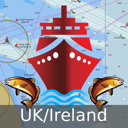
GPS Nautical Charts App offers access to RNC charts covering United Kingdom / Ireland waters (derived from UKHO data) with POI layers created from ENC charts. Only marine GPS app to have route assistance with Voice Prompts for marine navigation. It has route manager to create new boating routes or import existing GPX/KML routes. It supports Nautical Charts course up orientation.
Please visit http://www.gpsnauticalcharts.com/main/uk-nautical-charts-by-folio.html for complete list. If you don't find the chart for United Kingdom / Ireland, please contact us at support at gpsnauticalcharts.com.
* Voice Prompts for marine navigation (requires GPS )
-prompts when approaching a boating route marker
-Continous distance and ETA updates
-Alerts when sailing/boating off route
-Alerts when boating in wrong direction
*Route Editing/Creation
-Create routes from scratch
-Edit existing GPX/KML routes.
-Add custom description to any route point.
-Drop markers along route.
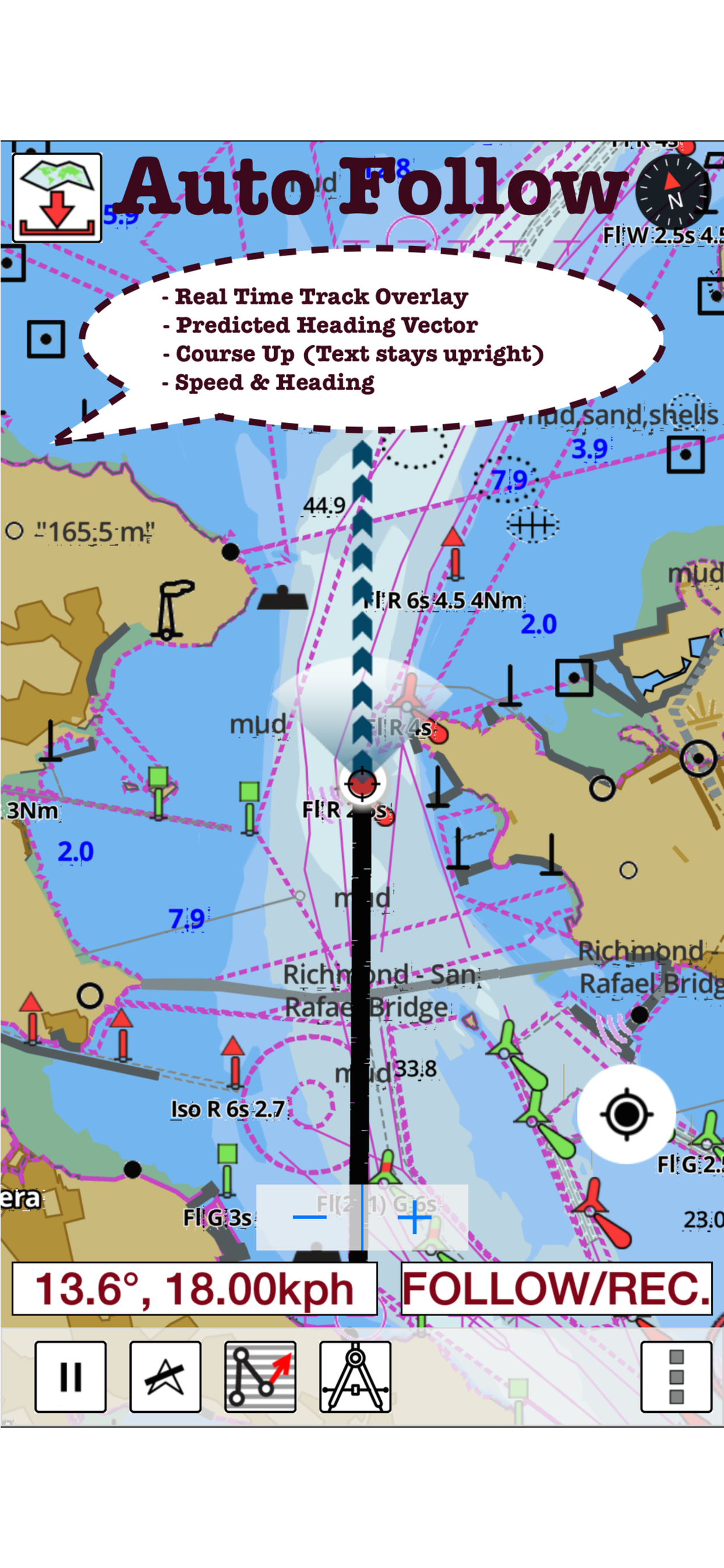
*Real time track overlay with projected heading vector
►SLIP TO SLIP AUTO ROUTING
►Instrumentation
√ Marine AIS & (NMEA AIS and GPS over TCP/UDP)
√ Wind direction & Speed,Marine Sonar depth,Water temperature
* Offline charts derived from UKHO data.
-Visually draw area to download
-Textual search
-Catalog (By state, region and coast guard district)
-Charts reprojected for WGS84 datum
*Seamless chart quilting of marine charts
*Distance Bearing tool
*Create custom way points
- Using GPS
-Select point on map
-Manually enter latitude & longitude coordinates
*Search POIs/Way points
*Tidal Prediction
*Pan/Zoom/My Location
* Record Marine GPS tracks
* View tracks overlay
* Live track animation
* Track analytics/stats
* Export GPX tracks.
-Export to SDCard
-Share GPX trakcs with friends.
* Auto Follow Mode (Course up)
-Continuously updates boat's location on chart
- Adjustable update frequency
Sample Nautical Charts (please visit http://www.gpsnauticalcharts.com/main/uk-nautical-charts-by-folio.html for complete list)
The Solent and Southampton Water
A Beaulieu River
Western Approaches to The Solent
Approaches to Portsmouth
Bill of Portland to the Needles
Bill of Portland to Anvil Point
Eastern Approaches to the Solent
G Lymington River
A Continuation of River Medina
Southampton Water and Approaches
Outer Approaches to the Solent
Port of Southampton
Selsey Bill to Beachy Head
Approaches to Portland and Weymouth
Cowes Harbour and River Medina
Berry Head to Bill of Portland
Entrance to River Hamble
Thames Estuary
B River Medina Folly Point to Newport
Portsmouth Harbour
Ashlett Creek
Yarmouth Harbour
Approaches to Keyhaven
Alum Bay
Newtown River
Approaches to Felixstowe, Harwich and Ipswich with the Rivers Stour, Orwell and Deben
Falmouth to Plymouth
G Hillhead Harbour
Dartmouth Harbour
Poole Harbour and Approaches
Poole Bay
Falmouth to Truro
B Upper Reaches of Beaulieu River
Continuation of Fareham Lake
River Yar
Wootton Creek
Langstone and Chichester Harbours
Lyme Regis Harbour
Brighton Marina
Land's End to Falmouth
Portsmouth Harbour Southern Part
Bembridge Harbour
Continuation of Holes Bay
Eddystone Rocks to Berry Head
Approaches to Padstow
Thames Estuary Northern Part
Freshwater Bay
Helford River Continuation to Gweek
Tor Bay
Portsmouth Harbour Northern Part
Lizard Point
Continuation to Port Solent
Start Point to Brixham
Continuation to Blackness Point
Newquay Bay
Salcombe to Start Point
Charlestown Harbour
Portland Harbour
River Thames Sea Reach
Penzance Bay
Caernarfon Bay
Bristol Channel
Mevagissey
Linney Head to Oxwich Point
Salcombe Harbour
Harwich and Felixstowe
Salcombe
Approaches to Falmouth
Par Harbour
Hide..
Show more..
Please visit http://www.gpsnauticalcharts.com/main/uk-nautical-charts-by-folio.html for complete list. If you don't find the chart for United Kingdom / Ireland, please contact us at support at gpsnauticalcharts.com.
* Voice Prompts for marine navigation (requires GPS )
-prompts when approaching a boating route marker
-Continous distance and ETA updates
-Alerts when sailing/boating off route
-Alerts when boating in wrong direction
*Route Editing/Creation
-Create routes from scratch
-Edit existing GPX/KML routes.
-Add custom description to any route point.
-Drop markers along route.
*Real time track overlay with projected heading vector
►SLIP TO SLIP AUTO ROUTING
►Instrumentation
√ Marine AIS & (NMEA AIS and GPS over TCP/UDP)
√ Wind direction & Speed,Marine Sonar depth,Water temperature
* Offline charts derived from UKHO data.
-Visually draw area to download
-Textual search
-Catalog (By state, region and coast guard district)
-Charts reprojected for WGS84 datum
*Seamless chart quilting of marine charts
*Distance Bearing tool
*Create custom way points
- Using GPS
-Select point on map
-Manually enter latitude & longitude coordinates
*Search POIs/Way points
*Tidal Prediction
*Pan/Zoom/My Location
* Record Marine GPS tracks
* View tracks overlay
* Live track animation
* Track analytics/stats
* Export GPX tracks.
-Export to SDCard
-Share GPX trakcs with friends.
* Auto Follow Mode (Course up)
-Continuously updates boat's location on chart
- Adjustable update frequency
Sample Nautical Charts (please visit http://www.gpsnauticalcharts.com/main/uk-nautical-charts-by-folio.html for complete list)
The Solent and Southampton Water
A Beaulieu River
Western Approaches to The Solent
Approaches to Portsmouth
Bill of Portland to the Needles
Bill of Portland to Anvil Point
Eastern Approaches to the Solent
G Lymington River
A Continuation of River Medina
Southampton Water and Approaches
Outer Approaches to the Solent
Port of Southampton
Selsey Bill to Beachy Head
Approaches to Portland and Weymouth
Cowes Harbour and River Medina
Berry Head to Bill of Portland
Entrance to River Hamble
Thames Estuary
B River Medina Folly Point to Newport
Portsmouth Harbour
Ashlett Creek
Yarmouth Harbour
Approaches to Keyhaven
Alum Bay
Newtown River
Approaches to Felixstowe, Harwich and Ipswich with the Rivers Stour, Orwell and Deben
Falmouth to Plymouth
G Hillhead Harbour
Dartmouth Harbour
Poole Harbour and Approaches
Poole Bay
Falmouth to Truro
B Upper Reaches of Beaulieu River
Continuation of Fareham Lake
River Yar
Wootton Creek
Langstone and Chichester Harbours
Lyme Regis Harbour
Brighton Marina
Land's End to Falmouth
Portsmouth Harbour Southern Part
Bembridge Harbour
Continuation of Holes Bay
Eddystone Rocks to Berry Head
Approaches to Padstow
Thames Estuary Northern Part
Freshwater Bay
Helford River Continuation to Gweek
Tor Bay
Portsmouth Harbour Northern Part
Lizard Point
Continuation to Port Solent
Start Point to Brixham
Continuation to Blackness Point
Newquay Bay
Salcombe to Start Point
Charlestown Harbour
Portland Harbour
River Thames Sea Reach
Penzance Bay
Caernarfon Bay
Bristol Channel
Mevagissey
Linney Head to Oxwich Point
Salcombe Harbour
Harwich and Felixstowe
Salcombe
Approaches to Falmouth
Par Harbour
In-Apps
- GPS Nautical Charts - UK /Ireland
- 12,990.00₸
Screenshots


 User Rating
0 out of 5
0 ratings in Kazakhstan
Ratings History
Reviews
App doesn't have any reviews yet
Store Rankings
Ranking History
App Ranking History not available yet
Category Rankings
|
Chart
|
Category
|
Rank
|
|---|---|---|
|
Top Paid
|

|
131
|
|
Top Paid
|

|
142
|
|
Top Paid
|

|
281
|
|
Top Paid
|

|
439
|
|
Top Paid
|

|
482
|
Keywords
Users may also like
| Name | Reviews | Recent release | |
|---|---|---|---|

SeaNav
Marine Charts and Navigation
|
0
|
3 weeks ago | |

Seawell Navigation Charts
Sea Navigation Marine Offline
|
0
|
2 years ago | |

Boat Watch Pro
Ship,Ferry & Cruise spotting
|
0
|
7 months ago | |

Nautical Charts & Maps
Nautical Charts & Marine Maps
|
0
|
3 months ago | |

Boat Beacon
AIS Marine Navigation
|
0
|
6 months ago | |

smartCHECK
|
0
|
4 months ago | |

SeaNav UK & Ireland
HD Marine Navigation & Charts
|
0
|
2 weeks ago | |

Wild Swimming Spain
|
0
|
1 month ago | |

SailTies: Logbook GPS Tracking
Sailing Resume, Qualifications
|
0
|
3 weeks ago | |

UK Ireland Nautical Charts HD
Same detail as a Chart plotter
|
0
|
2 years ago |
Show More
Revenue and Downloads
Gain valuable insights into Marine Navigation UK Ireland performance with our analytics. Sign up now
to
access downloads, revenue, and more.
App Info
- Category
- Travel
- Publisher
- Bist LLC
- Languages
- Russian, English, Dutch, German, Norwegian Bokmål, Finnish, French, Swedish
- Recent version
- 122.0.0 (2 years ago )
- Released on
- Aug 9, 2013 (10 years ago )
- Also available in
- United Kingdom, Pakistan, Italy, Japan, South Korea, Kuwait, Kazakhstan, Lebanon, Mexico, Malaysia, Nigeria, Netherlands, Norway, New Zealand, Peru, Philippines, India, Poland, Portugal, Romania, Russia, Saudi Arabia, Sweden, Singapore, Thailand, Turkey, Taiwan, Ukraine, United States, Vietnam, South Africa, Denmark, Argentina, Austria, Australia, Azerbaijan, Belgium, Brazil, Belarus, Canada, Switzerland, Chile, China, Colombia, Czechia, Germany, United Arab Emirates, Dominican Republic, Algeria, Ecuador, Egypt, Spain, Finland, France, Greece, Hong Kong, Hungary, Indonesia, Ireland, Israel
- Last updated
- 1 day ago