Mergin Maps: QGIS in pocket

QGIS field data collection app

Published by: LUTRA CONSULTING

Description

Simplify your field survey by capturing GPS field data on your mobile or tablet. Create mobile forms with the fields you require and invite your survey teams to complete them on their phones or tablets. Captured data, along with their location can be surveyed offline, then synced back to the QGIS in seconds.
Enter your data once, with ease, in the field. Mergin Maps aims to remove the pain of transcribing paper field notes, manually georeferencing photos and transcribing GPS coordinates.
The data you capture in the field survey is shown on a map and can be exported to a wide variety of formats including CSV, Microsoft Excel, ESRI Shapefile, Mapinfo, GeoPackage, PostGIS, AutoCAD DXF, KML and many more.
Mergin Maps Input is an extension of the free and open source GIS software QGIS. It allows you to open, interrogate and edit your QGIS projects on your mobile. Map layers look the same as in QGIS desktop and you can sync your data back and forward with QGIS desktop using the Mergin Maps QGIS plugin.
Mergin Maps supports offline field data capture and can be configured to use either offline or web-based background maps and contextual layers.
Perks of the Mergin Maps sync system:
- No need for cables to get your data on/off your device
- Share projects with others for collaborative working
- Safely work together on the same datasets, even offline
- Updates from different surveyors are intelligently merged
- Push data back from the field in real time
- Version history and cloud-based backup
- Fine-grained access control
- Sync with your PostGIS datasets
Supported field types for forms are:
- Text (single or multi-line)
- Numeric (plain, with +/- buttons or with slider)
- Date / time (with calendar picker)
- Photo
- Checkbox (yes/no values)
- Drop-down with predefined values
- Drop-down with values from another table
Forms can even be configured to perform data validation using custom rules.
Works with device internal GPS receiver and third-party Bluetooth GPS receivers.
Supported field types for forms are:
- Text (single or multi-line)
- Numeric (plain, with +/- buttons or with slider)
- Date / time (with calendar picker)
- Photo
- Checkbox (yes/no values)
- Drop-down with predefined values
- Drop-down with values from another table

Forms can even be configured to perform data validation using custom rules.

Works with device internal GPS receiver and third-party Bluetooth GPS receivers.
Hide Show More...

In-Apps

Mergin Individual Plan
¥248.00
Mergin Professional Plan
¥508.00

Screenshots

Mergin Maps FAQ

  • Is Mergin Maps free?

    Yes, Mergin Maps is free to download, however it contains in-app purchases or subscription offerings.

  • Is Mergin Maps legit?

    Not enough reviews to make a reliable assessment. The app needs more user feedback.

    Thanks for the vote

  • How much does Mergin Maps cost?

    Mergin Maps has several in-app purchases/subscriptions, the average in-app price is ¥378.00.

  • What is Mergin Maps revenue?

    To get estimated revenue of Mergin Maps app and other AppStore insights you can sign up to AppTail Mobile Analytics Platform.

User Rating
App is not rated in China yet.
Ratings History

Mergin Maps Reviews

Great App

TimB223456 on

United Kingdom

Easy to setup projects and use out in the field. Love it

Can’t down load App for iPhone

grassytile on

United Kingdom

Not a review but a request for help!!!! This app looks exactly what I need for work for plotting a variety of positions, however through the I store app or on line the app only sais “open”, I cannot find anyway to down load it. Am I missing something?? Thanks

Five star

Easyjetuser on

United Kingdom

Brilliant little app for field surveys. Obviously there’s always more things that could be added but it’s under active development so can’t wait to see what new features arrive. Thank you Lutra Consulting!

Brilliant for soil sampling

Becky Willson on

United Kingdom

This app has made my job so much easier and quicker! We use input for logging soil sample locations and observations in field. It works and is brilliant. So simple to use and has revolutionised field work!

Does exactly what you expect

Tarek Ball on

United Kingdom

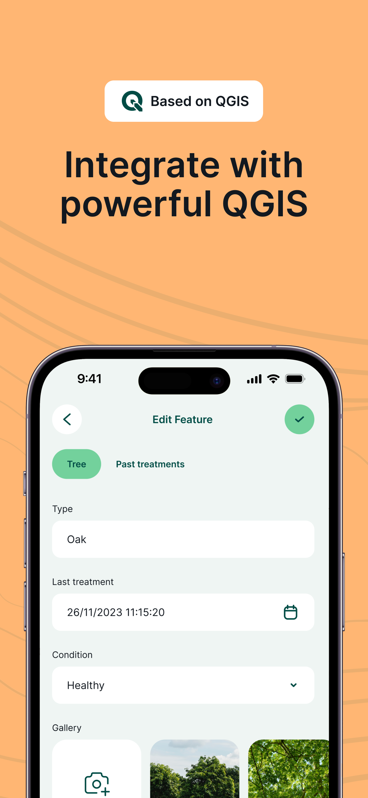
I have been using Input for surveying trees for the last few months now and it really is a lifesaver. The UI is simple and easy to understand and the cloud service offered, Mergin, works really very well. Once you’ve set up a project inside QGIS and any forms you wish to be filled out you can just plot items to you hearts content. Very impressed. The only improvement I could see atm would be to include a zoom slider on screen so that you can zoom in and put using a stylus. Other than that A++ 👌🏻

Great app - but no zoom controls

Ozlo24 on

United Kingdom

We have started to use this app for our surveying work on the UK uplands. The app is great - simple to use. The synchronisation with Mergin and QGIS projects has saved us a lot of time! One feature it is missing though is a dedicated zoom in and out control. It is possible to pinch to zoom, but we often need to wear gloves when surveying in the winter and having buttons for zoom controls would help massively. Also, the option to turn layer visibility on and off would be a useful addition.

Nice product, straightforward set up and good support.

postgrad design student on

United Kingdom

This app is wonderful to work with and offers so many possibilities. Full marks from me.

Store Rankings

Ranking History
App Ranking History not available yet
Category Rankings
App is not ranked yet

Mergin Maps Competitors

Mergin Maps Installs

Last 30 days

Mergin Maps Revenue

Last 30 days

Mergin Maps Revenue and Downloads

Gain valuable insights into Mergin Maps performance with our analytics.
Sign up now to access downloads, revenue, and more.

App Info

Category
Utilities
Publisher
LUTRA CONSULTING
Languages
English, Arabic, Azerbaijani, Catalan, Croatian, Czech, Dutch, Estonian, Finnish, French, German, Hungarian, Indonesian, Italian, Japanese, Polish, Portuguese, Chinese, Slovak, Slovene, Spanish, Vietnamese
Recent release
2025.4.1 (1 week ago )
Released on
Nov 16, 2019 (5 years ago )
Last Updated
5 months ago
This page includes copyrighted content from third parties, shared solely for commentary and research in accordance with fair use under applicable copyright laws. All trademarks, including product, service, and company names or logos, remain the property of their respective owners. Their use here falls under nominative fair use as outlined by trademark laws and does not suggest any affiliation with or endorsement by the trademark holders.