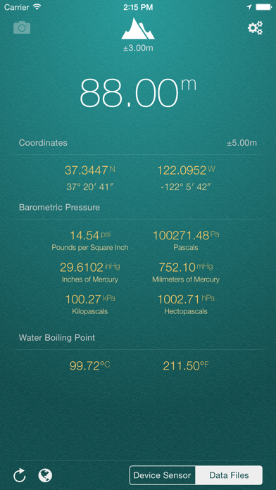
My Altitude uses GPS signals to determine your current location, showing your latitude, longitude and altitude (height from sea level) barometric pressure and water boiling point.
It's a free app and does not have any limitations. In-App purchase can be used to remove the bottom advertisement and to support us.
This application does not need an internet connection and works best in outdoors.
By default, it uses device sensor to determine the elevation from see level, but you also have the option to use NOAA data files to get the altitude of your location. On newer devices, using device sensor is more accurate.
It also allows you to get a picture of where you are and save it in photo album. Picture will be sealed with coordinates of current location along with altitude and local date/time.
Barometric Pressure is calculated based on elevation. On newer devices such as iPhone 6/6+ value is being delivered directly from device built-in barometric sensor, this behavior is configurable and you can switch back to calculation mode.
App Features:
- Elevation from see level in meter (metric) or feet (imperial)
- Change between metric and imperial systems by tapping on reported elevation
- Current location coordinates including latitude and longitude
- Barometric pressure in various units extracted from device sensor or calculated from altitude
- Water boiling point at your current location
- Current weather information including temperature, condition, humidity, wind speed and wind bearing
- World Altitude, get approximate altitude (elevation from see level) of any location in the world
- Save altitude data for reference
- Take a picture and watermark it with elevation information and share
Enjoy.
HideShow More...
Screenshots
My Altitude FAQ
Is My Altitude free?
Yes, My Altitude is completely free and it doesn't have any in-app purchases or subscriptions.
Is My Altitude legit?
🤔 The My Altitude app's quality is mixed. Some users are satisfied, while others report issues. Consider reading individual reviews for more context.
I wonder if something has changed in Apple Watch ultra which needs a change in your code.
If I loose a gps signal, the app will freeze its altitude on the ultra. In an aircraft, I would expect the app to show the cabin altitude as the aircraft climbed.
This may have worked on the Apple Watch 6 but doesn’t on the ultra.
Craig hunters app seems to be the only altimeter app working properly on my watch at the moment.
Does the job well!
A great little app for supplementary location and weather data.
Good app
The difference between sensor data and data files is significantly different it sometimes vary upto 120 meters. Not sure which one should I consider correct!??
Not sure If I believe it
Some altitudes are suspect and it does take a while to sort itself out. To be fair, I haven’t gone anywhere with a known height to compare yet.
Great
Everything it is supposed to be without the pointless frills
Awesome!!!!
Fantastic app. Very accurate and best one I have found after endless searching. Thank you.
It is great!
Simple...it is just great!
Works well but...
...needs to rotate on the iPad. Our iPads are in a case with a keyboard. Turning the head 90 degrees to view the app makes the neck ache :-)
Otherwise , useful utility and does what it does well.
Fix the rotation and we'll up it to 5 stars
Excellent app.
Does just what it says. Quick and simple.
Not that good
Even though it says it works better outside, the app never takes into account that there could wind or rain to make information accurate, should use Internet services to make this app worthwhile
This page includes copyrighted content from third parties, shared solely for commentary and research in accordance with fair use under applicable copyright laws. All trademarks, including product, service, and company names or logos, remain the property of their respective owners. Their use here falls under nominative fair use as outlined by trademark laws and does not suggest any affiliation with or endorsement by the trademark holders.