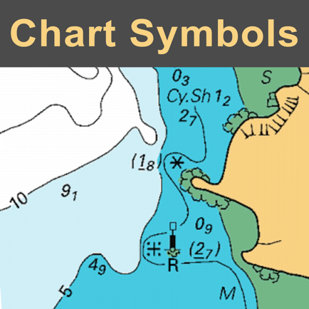
NAUTICAL CHART SYMBOLS & ABBREVIATIONS
Essential reference
#1 Keyword Rankings
Today
Top 10 Rankings
Today
Top 30 Rankings
Today
Top 100 Rankings
Today
Description
SYMBOLS USED ON NAUTICAL CHARTS SPECIFIED BY THE INTERNATIONAL HYDROGRAPHIC ORGANIZATION (IHO), PLUS INTERNATIONAL ABBREVIATIONS AND SUPPLEMENTARY NATIONAL SYMBOLS USED BY THE U.S. AND U.K. HYDROGRAPHIC OFFICES.
************ FEATURES and BENEFITS ************
- Perfect for reference, learning & revision
- Hi-res graphics
- Tap & Enlarge feature for greater detail
- Fully searchable index to all the symbols
- Always with you on your iPhone or iPad
- No internet connection needed
************ Plus FREE Bonus Content from "Safe Skipper" ************
"CHART SYMBOLS & ABBREVIATIONS" provides quick reference to the "INT 1" symbols specified by the International Hydrographic Organization (IHO) for use on International marine charts.
There are five main sections in this app, each with lettered sub-sections organized into categories to guide users through the hundreds of symbols. The main sections are:
GENERAL - chart layouts, positions, distances, directions and compass.
TOPOGRAPHY - landmarks, ports and coastal land features.
HYDROGRAPHY - tides, currents, depths, nature of the seabed, underwater obstructions, tracks, areas, limits and hydrographic terms.
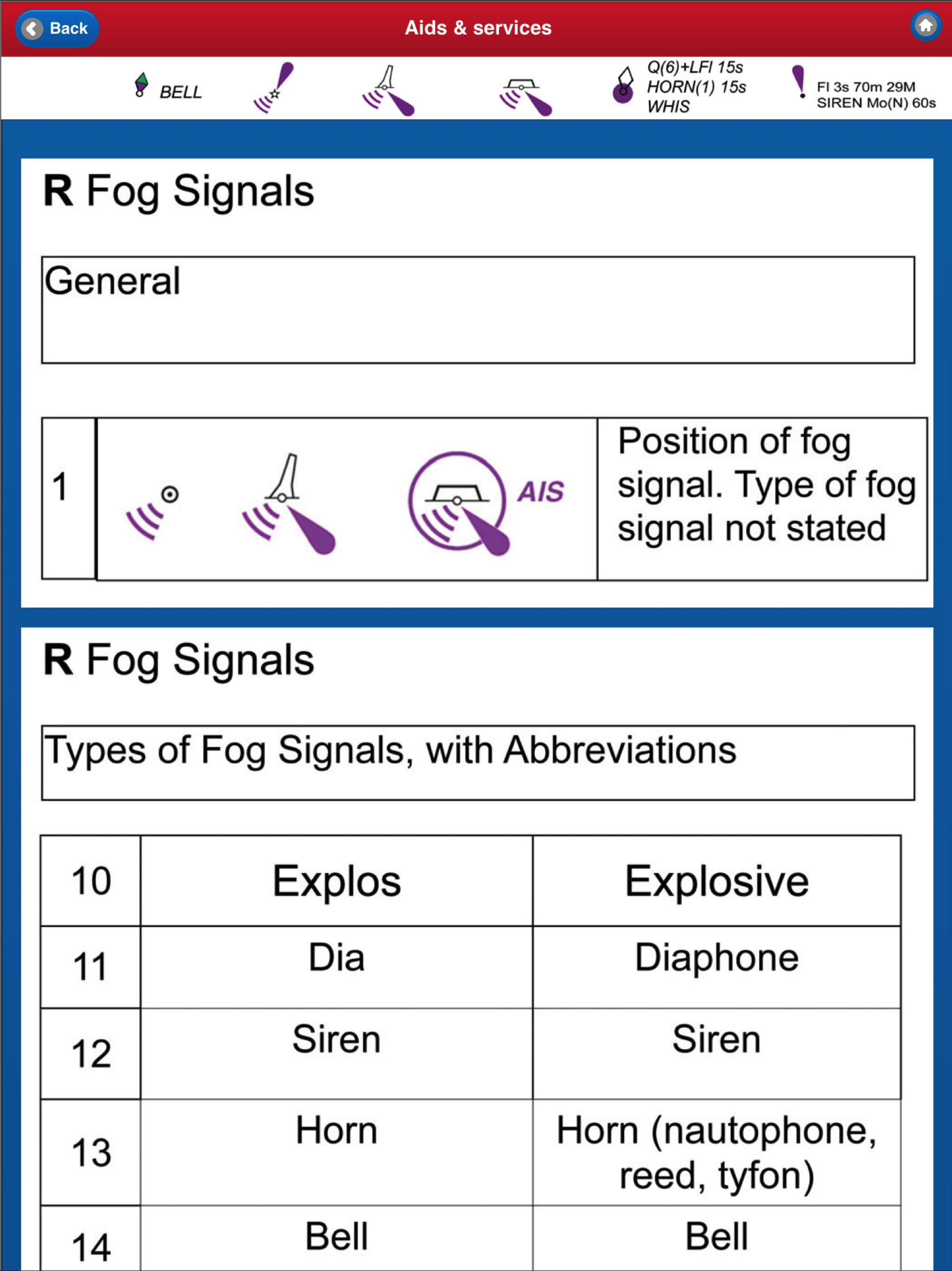
NAVIGATION AIDS & SERVICES - lights, buoys, fog signals, radar, radio, services and small craft facilities.
INDEX & ABBREVIATIONS - international abbreviations and index to symbols and abbreviations.
SUPPLEMENTARY NATIONAL SYMBOLS Supplementary National Symbols for nautical charts used by the United States and United Kingdom are included at the end of each section.
************* FREE Bonus Content from "Safe Skipper" *****************************
A bonus section has tips on how to deal with emergencies including: Abandon ship; Dismasting; Distress Signals; Engine Failure; Fire Fighting; Flares; Getting a tow; Helicopter rescue; Holed hull; Man overboard; Medical emergency; Mayday; Panpan; Securité.
INDEX The index is an A-Z of symbols and abbreviations and enables the user to quickly look up the symbols and see them in context with others in the same categories.
This app is based on the United Kingdom Hydrographic Office's print publication "Chart 5011 (INT 1) EDITION 2" Admiralty Charts Publication and "Chart No.1 United States of America Nautical Chart Symbols, Abbreviations and Terms".
NOTE: ECDIS symbols used to display Electronic Navigational Chart (ENC) data on Electronic Chart Display and Information Systems (ECDIS) as specified by the IHO are not included on this app.
We have an on-going program of marine navigation and boating safety apps, so please contact us with any ideas or features that you would like to see included.
Safe boating!
Hide..
Show more..
************ FEATURES and BENEFITS ************
- Perfect for reference, learning & revision
- Hi-res graphics
- Tap & Enlarge feature for greater detail
- Fully searchable index to all the symbols
- Always with you on your iPhone or iPad
- No internet connection needed
************ Plus FREE Bonus Content from "Safe Skipper" ************
"CHART SYMBOLS & ABBREVIATIONS" provides quick reference to the "INT 1" symbols specified by the International Hydrographic Organization (IHO) for use on International marine charts.
There are five main sections in this app, each with lettered sub-sections organized into categories to guide users through the hundreds of symbols. The main sections are:
GENERAL - chart layouts, positions, distances, directions and compass.
TOPOGRAPHY - landmarks, ports and coastal land features.
HYDROGRAPHY - tides, currents, depths, nature of the seabed, underwater obstructions, tracks, areas, limits and hydrographic terms.
NAVIGATION AIDS & SERVICES - lights, buoys, fog signals, radar, radio, services and small craft facilities.
INDEX & ABBREVIATIONS - international abbreviations and index to symbols and abbreviations.
SUPPLEMENTARY NATIONAL SYMBOLS Supplementary National Symbols for nautical charts used by the United States and United Kingdom are included at the end of each section.
************* FREE Bonus Content from "Safe Skipper" *****************************
A bonus section has tips on how to deal with emergencies including: Abandon ship; Dismasting; Distress Signals; Engine Failure; Fire Fighting; Flares; Getting a tow; Helicopter rescue; Holed hull; Man overboard; Medical emergency; Mayday; Panpan; Securité.
INDEX The index is an A-Z of symbols and abbreviations and enables the user to quickly look up the symbols and see them in context with others in the same categories.
This app is based on the United Kingdom Hydrographic Office's print publication "Chart 5011 (INT 1) EDITION 2" Admiralty Charts Publication and "Chart No.1 United States of America Nautical Chart Symbols, Abbreviations and Terms".
NOTE: ECDIS symbols used to display Electronic Navigational Chart (ENC) data on Electronic Chart Display and Information Systems (ECDIS) as specified by the IHO are not included on this app.
We have an on-going program of marine navigation and boating safety apps, so please contact us with any ideas or features that you would like to see included.
Safe boating!
Screenshots


 User Rating
0 out of 5
0 ratings in Finland
Ratings History
Reviews
App doesn't have any reviews yet
Store Rankings
Ranking History
App Ranking History not available yet
Category Rankings
|
Chart
|
Category
|
Rank
|
|---|---|---|
|
Top Paid
|

|
47
|
|
Top Paid
|

|
56
|
|
Top Paid
|

|
58
|
|
Top Paid
|

|
74
|
|
Top Paid
|

|
82
|
Keywords
Users may also like
| Name | Reviews | Recent release | |
|---|---|---|---|

StarPilot
|
1
|
2 years ago | |

TrackLink NauticEd
GPS Track Log for Sailors
|
0
|
1 year ago | |

Boat Beacon
AIS Marine Navigation
|
3
|
6 months ago | |
Compass Eye Bearing Compass
Augmented Reality compass
|
0
|
2 years ago | |

EZ Celestial Navigation
ezAlmanacOne
|
0
|
6 months ago | |

SeaNav UK & Ireland
HD Marine Navigation & Charts
|
0
|
3 weeks ago | |
iSailGPS NZ : NZ Marine Charts
New Zealand RNC Marine Charts
|
0
|
2 weeks ago | |

SailTies: Logbook GPS Tracking
Sailing Resume, Qualifications
|
0
|
1 month ago | |

UK Ireland Nautical Charts HD
Same detail as a Chart plotter
|
0
|
2 years ago | |

Navathome.com
|
0
|
3 months ago |
Show More
Revenue and Downloads
Gain valuable insights into NAUTICAL CHART SYMBOLS & ABBREVIATIONS performance with our analytics. Sign up now
to
access downloads, revenue, and more.
App Info
- Category
- Navigation
- Publisher
- The Other Hat
- Languages
- English
- Recent version
- 3.0 (6 years ago )
- Released on
- Aug 16, 2013 (10 years ago )
- Also available in
- United States, Germany, United Kingdom, Malaysia, Philippines, Peru, New Zealand, Norway, Netherlands, Nigeria, Poland, Mexico, Lebanon, Kazakhstan, Kuwait, South Korea, Japan, Pakistan, India, Portugal, Romania, Russia, Saudi Arabia, Sweden, Singapore, Thailand, Turkey, Taiwan, Ukraine, Vietnam, South Africa, Dominican Republic, Argentina, Austria, Australia, Azerbaijan, Belgium, Brazil, Belarus, Canada, Switzerland, Chile, China, Colombia, Czechia, Denmark, Italy, Algeria, Ecuador, Egypt, Spain, Finland, France, Greece, Hong Kong, Hungary, Indonesia, Ireland, Israel, United Arab Emirates
- Last updated
- 6 days ago