The first and still the best, NOAA Buoy and Tide Data allows you to retrieve weather data from NOAA's National Data Buoy Center. It also provides tide predictions for the US and Moon phase information.
The perfect tool to help plan your time on the water.
**For a map of buoys locations, go here: http://www.ndbc.noaa.gov/
* NEW - Home page lets you keep your most commonly used data in one place.
* Search for buoys by name.
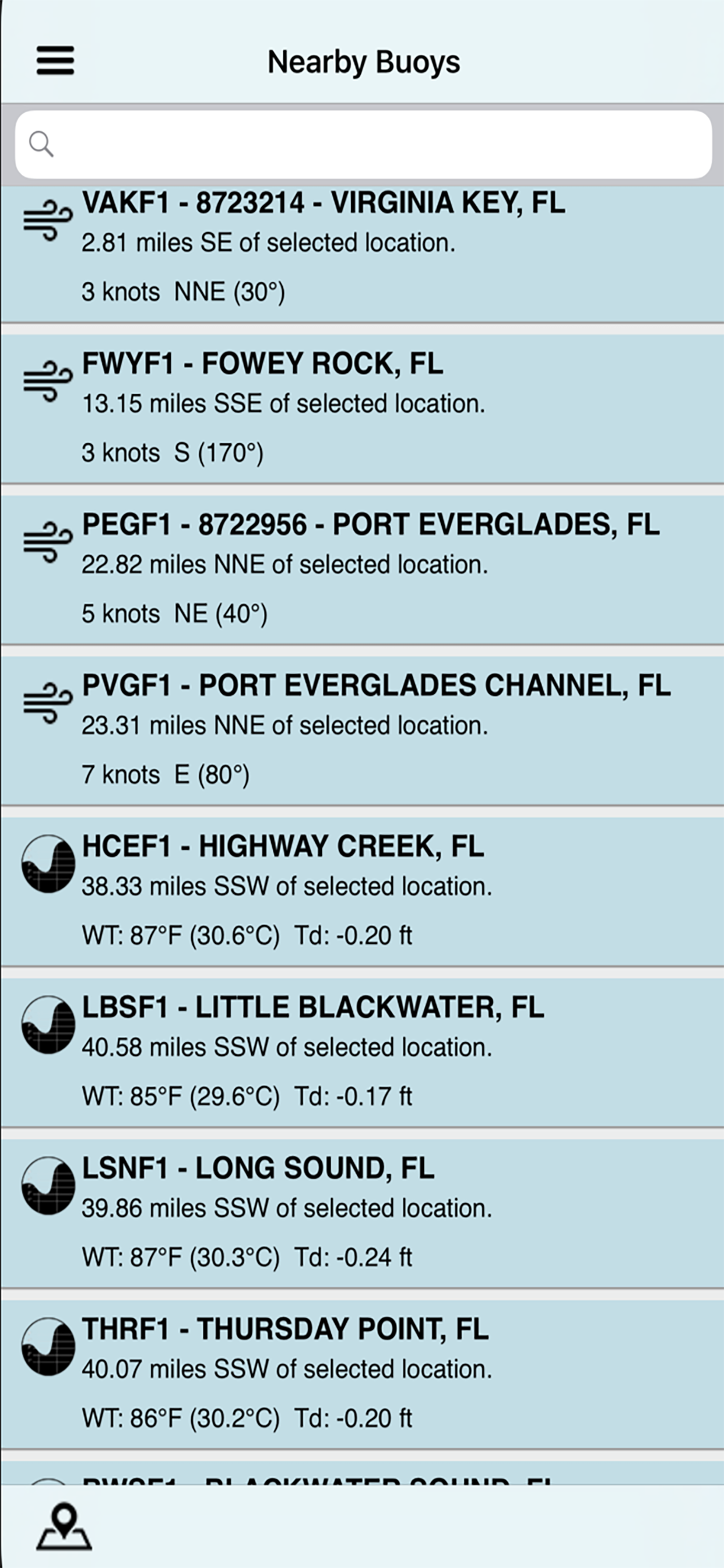
* View buoys near you with customizable search radius.
* Use GPS or manually entered location.
* Map of buoy locations.
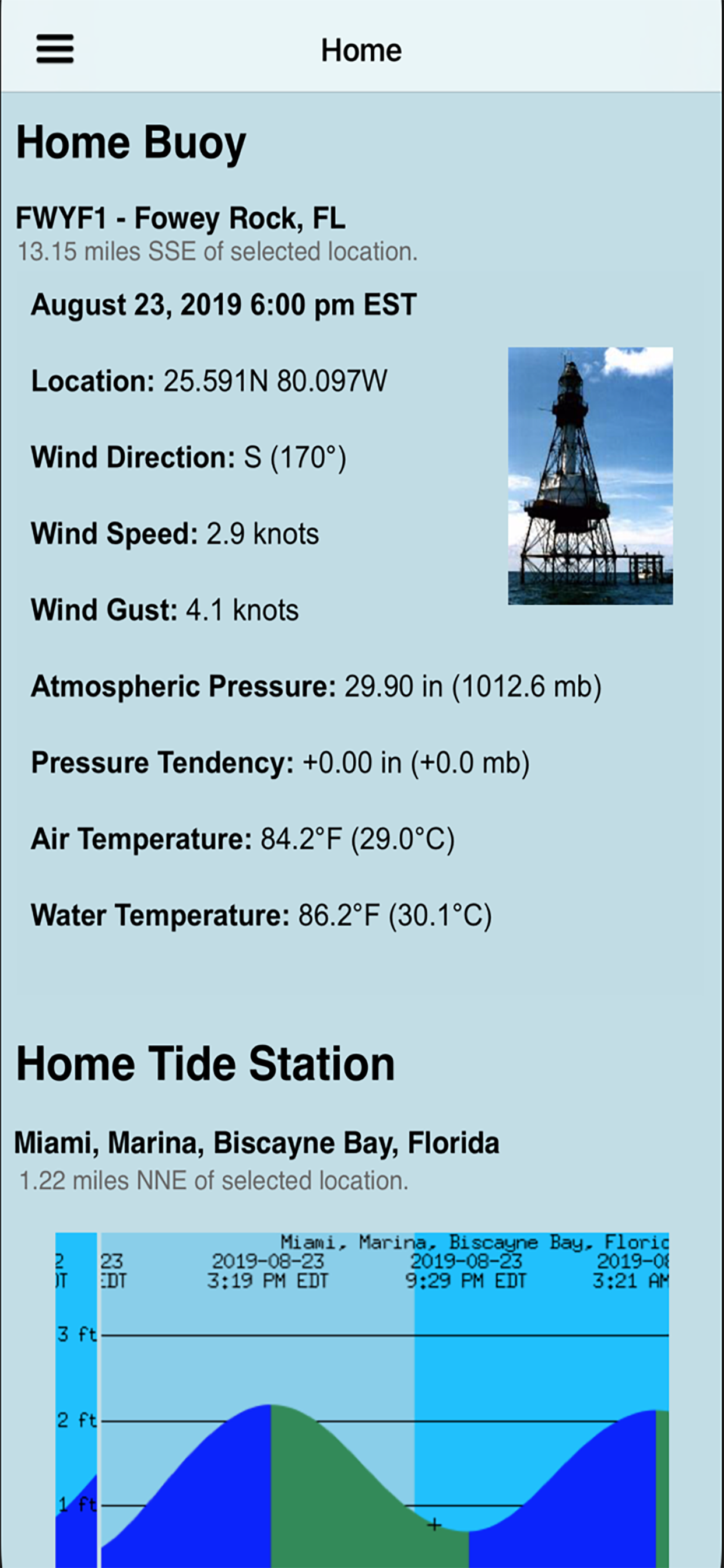
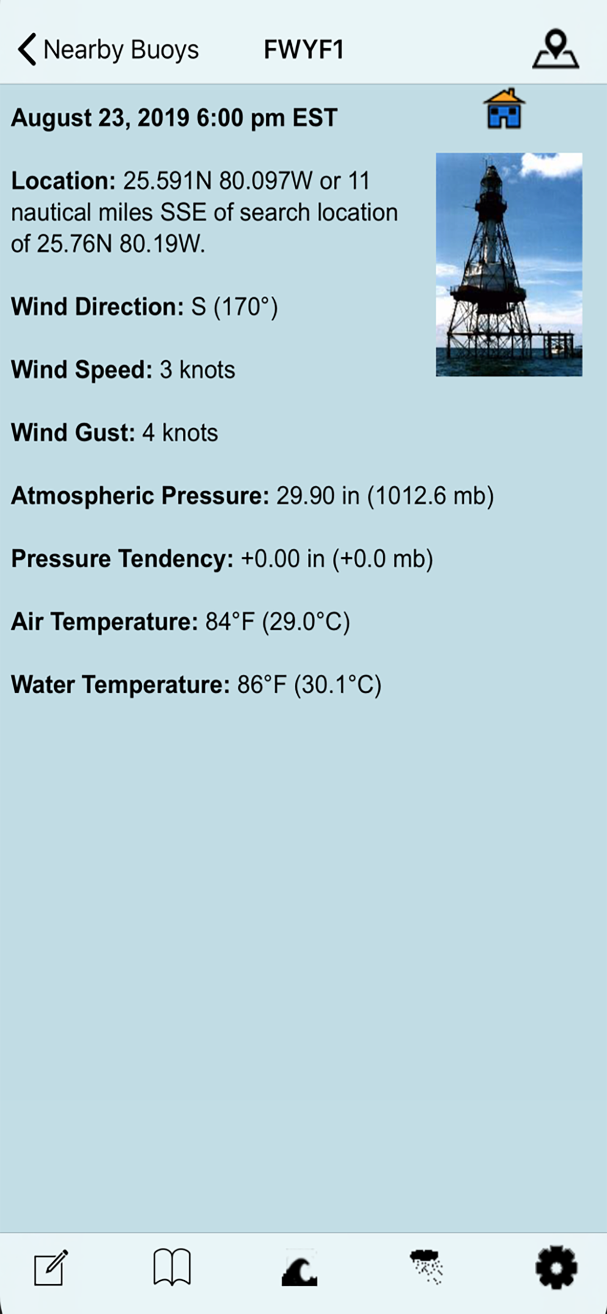
* Detailed live buoy data with access to location specific forecasts.
* Save your favorites for easy access.
* Quick access to buoy's website from within the application.
* Buoys sorted by proximity to your selected location.
* Tide Predictions.
* Moon phases.
Data can include wind speed, gusts, and direction as well as pressure and other relevant marine data. This data is dependent on the buoy since not all buoys have the same sensors.
If you participate in activities where marine weather is important, you need this app.
Great for:
boating
sailing
diving
fishing
kite boarding
and any activity where marine weather conditions are important.
If you fish at sea like we do, this is a great app for you.
Another quality App brought to you by boaters and fisherman. We use our products everyday and listen to our customers. If you have any issues, please contact us. We will reply.
HideShow More...
Screenshots
NOAA Buoy and Tide Data FAQ
Is NOAA Buoy and Tide Data free?
Yes, NOAA Buoy and Tide Data is completely free and it doesn't have any in-app purchases or subscriptions.
Is NOAA Buoy and Tide Data legit?
🤔 The NOAA Buoy and Tide Data app's quality is mixed. Some users are satisfied, while others report issues. Consider reading individual reviews for more context.
Thanks for the vote
How much does NOAA Buoy and Tide Data cost?
NOAA Buoy and Tide Data is free.
What is NOAA Buoy and Tide Data revenue?
To get estimated revenue of NOAA Buoy and Tide Data app and other AppStore insights you can sign up to AppTail Mobile Analytics Platform.
User Rating
5 out of 5
1 ratings in Canada
5 star
1
4 star
0
3 star
0
2 star
0
1 star
0
Ratings History
NOAA Buoy and Tide Data Reviews
Excellent; Maybe Life-Saving
This app provides ship reports of actual conditions around me in the Bahamas. When the weather is supposed to deteriorate, or when I don't trust the forecast (which is often) I use this app to find out what is really happening.
When the forecaster calls for a front with winds, say, in the 20-25kt range, I get the ship reports sorted by distance to see if it is better or worse than expected. Frequently, I have seen ship reports of winds far in excess of the predictions. The map view allows me to follow the front as it approaches and to check whether a report likely represents a localized squall or a general condition on the other side of the front. This allows me to take precautions like setting another anchor, or reefing the sails, or finding sheltered harbour.
The data is presented very well. I have tried to find it directly at NOAA, but with no success. It is pretty challenging to pick a few reports out of a long tabular list of NOAA data when the weather's getting bad at sea. The map function is critical.
Admittedly, you do have to have Internet access on your boat to use this, but that is becoming much cheaper and more readily available.
This is the only weather app that allows me to easily check actual conditions. I use it almost every day.
Please update
Aloha, I really like the format of this app. But now it does not load on my iPad Pro 11” running software 15.6.1 version.
No longer functions
Shut down phone
Reloaded app
Hasn’t updated in 7 days
Received a response from developers
Apparently the problem is with noaa
Update 9/18/2020: old problems fixed, good to go
I walk my dogs next to the SF Bay, and this app will tell me the temperature and velocity of the wind off the water. My regular weather app (Weather On) is right on the money for ambient temp and wind speed, but the buoy data tells me the wind temp and speed off the water, and whether or not I'll need a jacket. Maybe a "one trick pony", but it's really good at it, and I use it every day for that. The tide data is there also, but is easier to read in Tide Graph Pro. I'd buy both, if you're by the water. Tip: Pick a few “favorite” buoys near you, and those are the only ones that will come up when you tap favorites (so you don’t have to sort through all the weather on the coast, but you can if you wish). The app responds quickly, so the delay from home; screen to favorite buoy air temp and wind speed takes about 3 or 4 seconds max. Simple, and well written. Good Job.
Thanks
The data is older than some other apps that I am looking at. Used to be more timely. Now the email address doesn’t work either.
The BEST!
Hands-down my favorite weather app for near a decade now.
Excited to see it’s being actively developed again. This is by far the best weather app for any nautical area. No frills, accurate and timely data from an authentic, authoritative source.
Thank you for developing this- I depend on it every day. 🙏🏼👍🏼
Sea height
Why does the data show the sea height anymore?
Fixed and working!
I submitted a review saying the app keeps crashing when I try to open the app, preventing me from using the app, and I asked for the developers to fix this issue. Within days of submitting the review they released an update that solved the issue and the app works great! Thank you for the great customer service!
Worked pretty well for a couple of years but its broken
The app worked well for a few years. A couple of weeks ago it began to hang on the opening screen and then just crashes back to the app icon. This app is broken on my iPhone and ipad.
Best App for the Professional Mariner
As a yacht delivery captain who delivered vessels all over the world, this app has been my go-to marine weather resource. I have bought other apps that claim to be NOAA Data Buoy but fail miserably in provide NOAA textual data. This app provides marine weather forecasts as well as current and historical data verbatim from NDBC/NOAA. Don’t waste your time or money. Take it from a professional mariner. This is the app you need.
This page includes copyrighted content from third parties, shared solely for commentary and research in accordance with fair use under applicable copyright laws. All trademarks, including product, service, and company names or logos, remain the property of their respective owners. Their use here falls under nominative fair use as outlined by trademark laws and does not suggest any affiliation with or endorsement by the trademark holders.