
North Carolina Pocket Maps
North Carolina Outdoor Guide
#1 Keyword Rankings
Today
Top 10 Rankings
Today
Top 30 Rankings
Today
Top 100 Rankings
Today
Description
Be prepared! Plan your next trip to one of the great North Carolina parks. Download maps and guides before you venture into the Wi-Fi free wilderness.
Discover
- 70+ national parks, state parks, monuments, forests
- 50+ neatly folded maps by the National Park Service, Bureau of Land Management, United States Forest Services, and other agencies.
- Motor Vehicle Use Maps (MVUM), Motor Vehicle Travel Maps (MVTM) and visitor maps for California national forests.
- 600+ campgrounds and campsites
- 900+ trails and trailheads
- 61,000+ points of interests
Plan
- Download maps, park brochures, and newspapers. These downloads are ready when you are offline and off the grid in the great outdoors.
- Download arbitrary map sections as offline packs.
- Photo galleries, panorama views.
- Share links to parks and maps with friends
Have fun
- GPS and GPX support: record your hikes, import GPX routes, tracks and waypoints for your hiking trails.
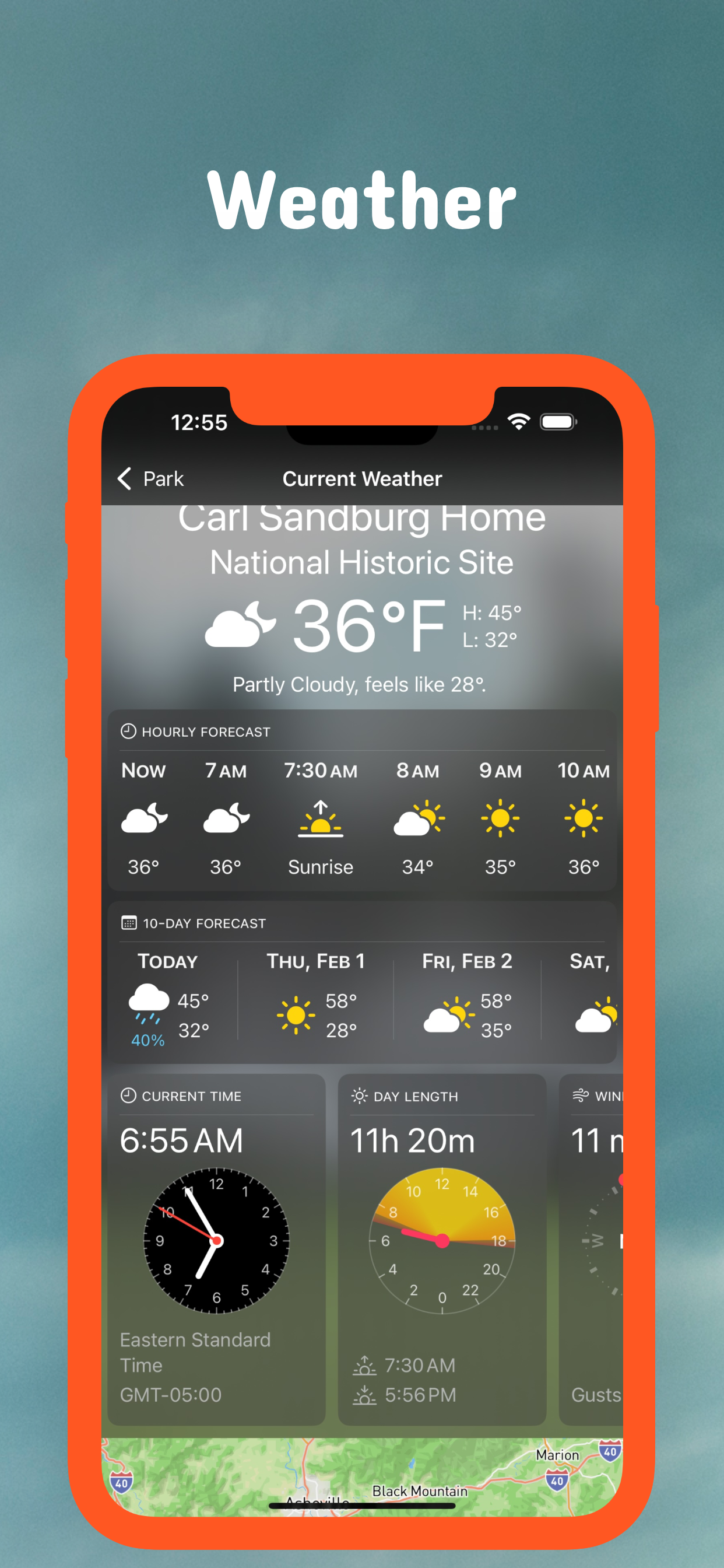
- Detailed national park information: alerts, news, visitor centers, campgrounds, driving directions, weather.
- Open your favorite maps app to get a route to the selected park.
- Current weather conditions, easy access to multi-day forecasts, sunrise and sunset times.
- Push notifications for park alerts, park news, weather warnings
So download maps and guides for:
Blue Ridge
Cape Hatteras
Cape Lookout
Carolina Beach
Chimney Rock
Croatan
Elk Knob
Fort Macon
Fort Raleigh
Gorges
Grandfather Mountain
Great Smoky Mountains
Guilford Courthouse
Hanging Rock
Nantahala
Pisgah
South Mountains
Stone Mountain
Uwharrie
Wright Brothers
There are additional useful information and brochures for:
Appalachian, Carl Sandburg Home, Carvers Creek, Cliffs of the Neuse, Crowders Mountain, Dismal Swamp, Eno River, Falls Lake, Fort Fisher, Goose Creek, Gullah/Geechee, Hammocks Beach, Lumber River, Moores Creek, Overmountain Victory, Pettigrew
- FULL ACCESS is available for a for $3.49/three month (after a free 3-days trial period) or $2.49/two months or $7.49/year. You can subscribe and pay through your iTunes account. The account will be charged for renewal within 24-hours prior to the end of the current period, and identify the cost of the renewal. Your subscription will automatically renew unless canceled at least 24 hours before the end of the current period. Auto-renew can be turned off anytime by going to your Account Settings in iTunes after purchase.
- Continued use of GPS running in the background can dramatically decrease battery life.
LEGAL
Terms of Use: https://www.icoat.de/pocketmaps/terms
Privacy Policy: https://www.icoat.de/pocketmaps/privacy
Hide..
Show more..
Discover
- 70+ national parks, state parks, monuments, forests
- 50+ neatly folded maps by the National Park Service, Bureau of Land Management, United States Forest Services, and other agencies.
- Motor Vehicle Use Maps (MVUM), Motor Vehicle Travel Maps (MVTM) and visitor maps for California national forests.
- 600+ campgrounds and campsites
- 900+ trails and trailheads
- 61,000+ points of interests
Plan
- Download maps, park brochures, and newspapers. These downloads are ready when you are offline and off the grid in the great outdoors.
- Download arbitrary map sections as offline packs.
- Photo galleries, panorama views.
- Share links to parks and maps with friends
Have fun
- GPS and GPX support: record your hikes, import GPX routes, tracks and waypoints for your hiking trails.
- Detailed national park information: alerts, news, visitor centers, campgrounds, driving directions, weather.
- Open your favorite maps app to get a route to the selected park.
- Current weather conditions, easy access to multi-day forecasts, sunrise and sunset times.
- Push notifications for park alerts, park news, weather warnings
So download maps and guides for:
Blue Ridge
Cape Hatteras
Cape Lookout
Carolina Beach
Chimney Rock
Croatan
Elk Knob
Fort Macon
Fort Raleigh
Gorges
Grandfather Mountain
Great Smoky Mountains
Guilford Courthouse
Hanging Rock
Nantahala
Pisgah
South Mountains
Stone Mountain
Uwharrie
Wright Brothers
There are additional useful information and brochures for:
Appalachian, Carl Sandburg Home, Carvers Creek, Cliffs of the Neuse, Crowders Mountain, Dismal Swamp, Eno River, Falls Lake, Fort Fisher, Goose Creek, Gullah/Geechee, Hammocks Beach, Lumber River, Moores Creek, Overmountain Victory, Pettigrew
- FULL ACCESS is available for a for $3.49/three month (after a free 3-days trial period) or $2.49/two months or $7.49/year. You can subscribe and pay through your iTunes account. The account will be charged for renewal within 24-hours prior to the end of the current period, and identify the cost of the renewal. Your subscription will automatically renew unless canceled at least 24 hours before the end of the current period. Auto-renew can be turned off anytime by going to your Account Settings in iTunes after purchase.
- Continued use of GPS running in the background can dramatically decrease battery life.
LEGAL
Terms of Use: https://www.icoat.de/pocketmaps/terms
Privacy Policy: https://www.icoat.de/pocketmaps/privacy
In-Apps
- access all pro features
- 7,49 €
Screenshots


 User Rating
0 out of 5
0 ratings in Spain
Ratings History
Reviews
App doesn't have any reviews yet
Store Rankings
Ranking History
App Ranking History not available yet
Category Rankings
App is not ranked yet
Keywords
Users may also like
| Name | Reviews | Recent release | |
|---|---|---|---|

ParkPassport
|
0
|
1 month ago | |
NP Maps
National Park & Topos maps USA
|
0
|
1 year ago | |

The MST Guide
Hike North Carolina
|
0
|
2 years ago | |

Visit NC Farms
|
0
|
3 months ago | |

Blue Ridge Parkway Audio Guide
Self-Driving Narrated GPS Tour
|
0
|
2 years ago | |

Dig Local
Asheville's App - Things to do
|
0
|
10 months ago | |

Blue Ridge Parkway Guide
|
0
|
1 year ago | |

Great Smoky National Park Tour
Cades Cove Driving Audio Guide
|
0
|
10 months ago | |

Cades Cove Visitor Guide
|
0
|
1 year ago | |

OBX Tourist Guide
|
0
|
1 year ago |
Show More
Revenue and Downloads
Gain valuable insights into North Carolina Pocket Maps performance with our analytics. Sign up now
to
access downloads, revenue, and more.
App Info
- Category
- Travel
- Publisher
- Alex Gugel
- Languages
- German, Spanish, English, Italian, Portuguese, Polish, Turkish, Danish, Russian, Swedish, Chinese, French, Catalan, Korean, Hindi, Dutch, Japanese, Greek (modern)
- Recent version
- 6.5 (1 day ago )
- Released on
- Dec 4, 2019 (4 years ago )
- Also available in
- United States, Germany, Indonesia, Mexico, Philippines, Peru, New Zealand, Norway, Netherlands, Nigeria, Malaysia, Poland, Lebanon, Kazakhstan, Kuwait, South Korea, Japan, Pakistan, India, Portugal, Romania, Russia, Saudi Arabia, Sweden, Singapore, Thailand, Turkey, Taiwan, Ukraine, Vietnam, South Africa, Dominican Republic, Argentina, Austria, Australia, Azerbaijan, Belgium, Brazil, Belarus, Canada, Switzerland, Chile, China, Colombia, Czechia, Denmark, Italy, Algeria, Ecuador, Egypt, Spain, Finland, France, United Kingdom, Greece, Hong Kong, Hungary, Ireland, Israel, United Arab Emirates
- Last updated
- 2 months ago