
PIX4Dcatch: 3D scanner
3D models from images & LiDAR
#1 Keyword Rankings
Today
Top 10 Rankings
Today
Top 30 Rankings
Today
Top 100 Rankings
Today
Description
With PIX4Dcatch, create 3D models and maps with your mobile device. Just point and capture to gather data, ready for accurate 3D model generation. Use it to recreate reality and measure the world around you.
You can pair it with a compatible RTK device to achieve centimeter-level accuracy for better 3D model precision and geolocation, and for performing single-point measurements.
To generate georeferenced 3D models, the collected images can be uploaded to PIX4Dcloud or exported to PIX4Dmatic. Both offer a 15-day trial to get started. Projects can also be freely exported, processed, and visualized in third-party photogrammetry software.
Workflow
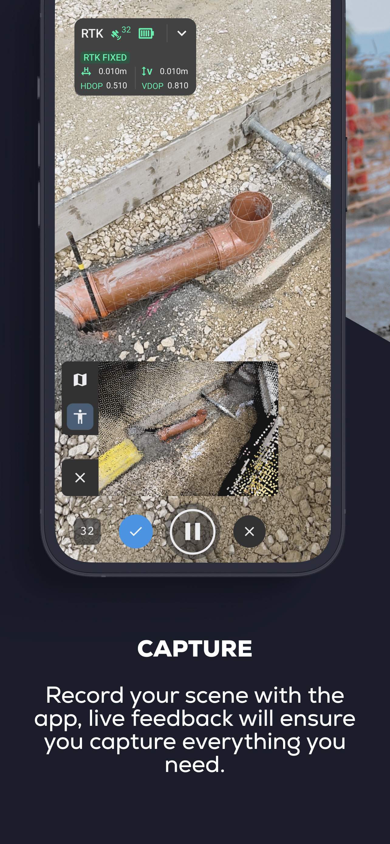
1 - Scan: walk around your site. The app automatically gathers data and gives live feedback with iOS LiDAR, ensuring you capture every detail. For better accuracy, you can use either an RTK device compatible with PIX4Dcatch, our Pix4D targets with a fully automated workflow, or combine both for really accurate results.
2 - Upload or export: to process the data, upload it to PIX4Dcloud or export it to desktop software PIX4Dmatic. Get high-quality, accurate 2D and 3D outputs.
3 - Analyze and share: measure the space, share your results, and enjoy all the benefits of a detailed 3D model of your surroundings. Benefit from an immersive experience with augmented reality.
This workflow can be used for digitizing construction sites, measuring volumes (of stockpiles and other objects), keeping permanent records of underground utilities, and verifying your previously captured 3D models in AR in real time. Measure single points with confidence by using our compatible RTK devices. Digitize reality with your mobile phone.
Compatibility:
• Optimized for LiDAR-equipped devices
• All ARKit-enabled devices
• RTK devices: Pix4D adapted viDoc RTK, Emlid Reach RX, Trimble DA2
Usage information guidance:
Ensure the app is up to date.
Pix4D accepts no liability for damage, injuries, or legalities from the misuse of this app. Use only in safe environments.
Terms of Use:
https://www.apple.com/legal/internet-services/itunes/dev/stdeula/
Hide..
Show more..
You can pair it with a compatible RTK device to achieve centimeter-level accuracy for better 3D model precision and geolocation, and for performing single-point measurements.
To generate georeferenced 3D models, the collected images can be uploaded to PIX4Dcloud or exported to PIX4Dmatic. Both offer a 15-day trial to get started. Projects can also be freely exported, processed, and visualized in third-party photogrammetry software.
Workflow
1 - Scan: walk around your site. The app automatically gathers data and gives live feedback with iOS LiDAR, ensuring you capture every detail. For better accuracy, you can use either an RTK device compatible with PIX4Dcatch, our Pix4D targets with a fully automated workflow, or combine both for really accurate results.
2 - Upload or export: to process the data, upload it to PIX4Dcloud or export it to desktop software PIX4Dmatic. Get high-quality, accurate 2D and 3D outputs.
3 - Analyze and share: measure the space, share your results, and enjoy all the benefits of a detailed 3D model of your surroundings. Benefit from an immersive experience with augmented reality.
This workflow can be used for digitizing construction sites, measuring volumes (of stockpiles and other objects), keeping permanent records of underground utilities, and verifying your previously captured 3D models in AR in real time. Measure single points with confidence by using our compatible RTK devices. Digitize reality with your mobile phone.
Compatibility:
• Optimized for LiDAR-equipped devices
• All ARKit-enabled devices
• RTK devices: Pix4D adapted viDoc RTK, Emlid Reach RX, Trimble DA2
Usage information guidance:
Ensure the app is up to date.
Pix4D accepts no liability for damage, injuries, or legalities from the misuse of this app. Use only in safe environments.
Terms of Use:
https://www.apple.com/legal/internet-services/itunes/dev/stdeula/
Screenshots


 User Rating
5 out of 5
4 ratings in Austria
5 star
4
4 star
0
3 star
0
2 star
0
1 star
0
Ratings History
Reviews
Store Rankings
Ranking History
App Ranking History not available yet
Category Rankings
App is not ranked yet
Keywords
Users may also like
| Name | Reviews | Recent release | |
|---|---|---|---|

Canvas: LiDAR 3D Measurements
Fast, Easy As-Built CAD/BIM
|
0
|
3 days ago | |

Scandy Pro: 3D Scanner, 3D App
Capture. Scan. Edit. 3D Model.
|
1
|
2 months ago | |

Canvas Lite for Homeowners
Remote 3D Home Measurement
|
0
|
5 months ago | |

SiteScape - LiDAR 3D Scanner
3D Scanning for Construction
|
1
|
1 month ago | |

DJI Pilot
|
0
|
3 years ago | |

RTAB-Map - 3D LiDAR Scanner
Open Source Visual/LiDAR SLAM
|
1
|
9 months ago | |

Airdata UAV
|
0
|
1 week ago | |

Dronelink Flight
Reimagine Drone Flight
|
1
|
1 month ago | |

Emlid Flow
Reach companion app
|
0
|
3 weeks ago | |

Drone Harmony Mobile
Flight execution app for IOS
|
0
|
1 year ago |
Show More
Revenue and Downloads
Gain valuable insights into PIX4Dcatch: 3D scanner performance with our analytics. Sign up now
to
access downloads, revenue, and more.
App Info
- Category
- Utilities
- Publisher
- Pix4D SA
- Languages
- Chinese, English, French, German, Japanese, Spanish
- Recent version
- 2.1.1 (1 week ago )
- Released on
- Jun 12, 2020 (4 years ago )
- Also available in
- United States, Japan, Germany, Switzerland, France, United Kingdom, Australia, Spain, Norway, Canada, Italy, South Korea, Colombia, Taiwan, Turkey, Mexico, Netherlands, Brazil, Poland, South Africa, New Zealand, Chile, China, Belgium, Czechia, Singapore, Sweden, Ukraine, Argentina, Hungary, Russia, Thailand, Finland, Hong Kong, Denmark, Portugal, Peru, Greece, Austria, Malaysia, Romania, Belarus, Indonesia, Vietnam, Philippines, Azerbaijan, Dominican Republic, Algeria, Saudi Arabia, United Arab Emirates, Ecuador, Israel, Ireland, Pakistan, Egypt, Nigeria, Lebanon, Kazakhstan, Kuwait, India
- Last updated
- 1 week ago