Plate Tectonics Visual Glossary and Atlas
Published by: DK Tasa
Description
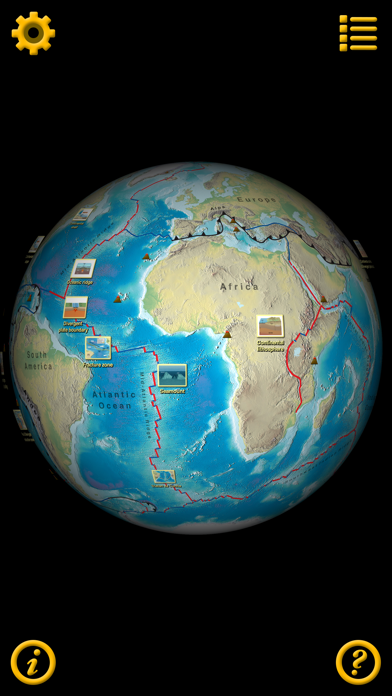
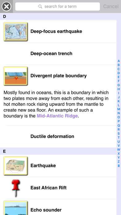
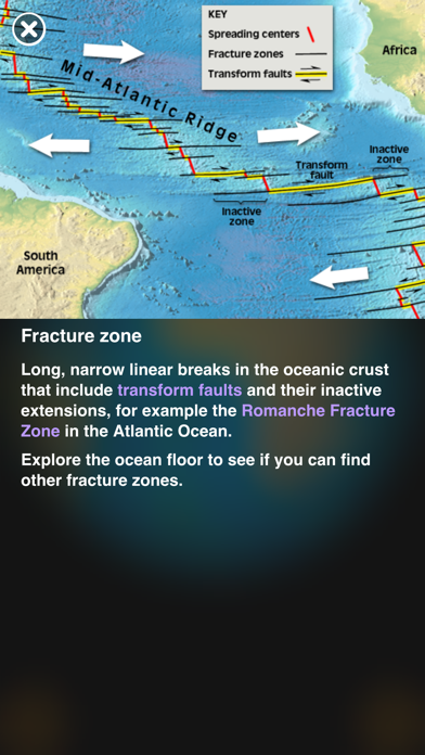
A comprehensive glossary of terms and definitions related to plate tectonics with visuals that include illustrations, animations, photos, and videos. Using a 3D globe with surface maps that show Earth’s geologic features, terms are related to the features that are a direct result of the motion of tectonic plates. View terms and definitions from a searchable list or click an icon in the list to go to its specific location on the globe.
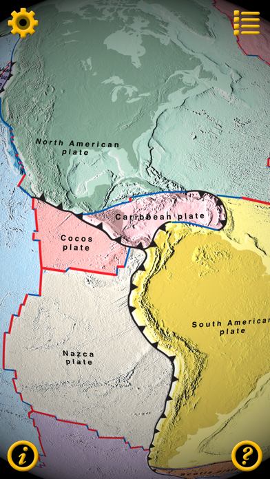
The app provides a visual experience that encourages discovery by exploration of Earth’s surface. See how changes in plate boundaries cause earthquakes, volcanoes, and mountain building. Select an alternate surface map that shows the sizes and shapes of the major tectonic plates or a map that illustrates the age of the ocean floor. Control the visibility of overlays for plate boundaries, map labels, term icons, and a coordinate grid. Another overlay shows major earthquakes since 1900 which graphically illustrates activity at plate boundaries. Or, just turn off all overlays and explore Earth’s surface.
• Surface maps illustrate Earth’s physiographic features, plate shapes, or the age of the oceanic lithosphere
• Overlays for: plate boundaries, map labels, terms at geographic locations, a latitude/longitude grid, and major earthquakes since 1900
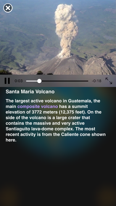
• approximately 240 terms and geographic locations with definitions and descriptions
• most definitions have illustrations, animations, or photos
• locations have descriptive text and spin the globe to show the location on Earth
• definitions provide links to related terms
• simple, intuitive user interface: drag, pinch, tap
• universal app
• optimized for large screens, supports all screen sizes and orientations
• supports side-by-side split-view
• no internet connection required
Correlates to Next Generation Science Standards for Earth Science:
ESS2.A: Earth Materials and Systems
ESS2.B: Plate Tectonics and Large-Scale System Interactions
ESS3.B: Natural Hazards
ESS1.C: The History of Planet Earth
Supports inquiry-based learning about plate tectonics by providing an exploration of Earth that illustrates the relationship between surface features and plate tectonics. The definitions aid students when writing about or discussing the interaction of Earth’s tectonic plates, earthquakes, and volcanoes. The app encourages higher-order thinking skills by displaying data (historical earthquakes, age of the oceans, volcano locations) that requires analysis, supports the formulation of theories, and tests those theories.
Hide..
Show more..
The app provides a visual experience that encourages discovery by exploration of Earth’s surface. See how changes in plate boundaries cause earthquakes, volcanoes, and mountain building. Select an alternate surface map that shows the sizes and shapes of the major tectonic plates or a map that illustrates the age of the ocean floor. Control the visibility of overlays for plate boundaries, map labels, term icons, and a coordinate grid. Another overlay shows major earthquakes since 1900 which graphically illustrates activity at plate boundaries. Or, just turn off all overlays and explore Earth’s surface.
• Surface maps illustrate Earth’s physiographic features, plate shapes, or the age of the oceanic lithosphere
• Overlays for: plate boundaries, map labels, terms at geographic locations, a latitude/longitude grid, and major earthquakes since 1900
• approximately 240 terms and geographic locations with definitions and descriptions
• most definitions have illustrations, animations, or photos
• locations have descriptive text and spin the globe to show the location on Earth
• definitions provide links to related terms
• simple, intuitive user interface: drag, pinch, tap
• universal app
• optimized for large screens, supports all screen sizes and orientations
• supports side-by-side split-view
• no internet connection required
Correlates to Next Generation Science Standards for Earth Science:
ESS2.A: Earth Materials and Systems
ESS2.B: Plate Tectonics and Large-Scale System Interactions
ESS3.B: Natural Hazards
ESS1.C: The History of Planet Earth
Supports inquiry-based learning about plate tectonics by providing an exploration of Earth that illustrates the relationship between surface features and plate tectonics. The definitions aid students when writing about or discussing the interaction of Earth’s tectonic plates, earthquakes, and volcanoes. The app encourages higher-order thinking skills by displaying data (historical earthquakes, age of the oceans, volcano locations) that requires analysis, supports the formulation of theories, and tests those theories.
Screenshots

User Rating
App is not rated in Russia yet.
Ratings History
Plate Tectonics Visual Glossary and Atlas Installs
Last 30 days
Plate Tectonics Visual Glossary and Atlas Revenue
Last 30 daysPlate Tectonics Visual Glossary and Atlas Reviews
Store Rankings
Ranking History
App Ranking History not available yet
Category Rankings
|
Chart
|
Category
|
Rank
|
|---|---|---|
|
Top Paid
|

|
470
|
Keywords
Plate Tectonics Visual Glossary and Atlas Competitors
| Name | Reviews | Recent release | |
|---|---|---|---|
Word and Phrase Etymology
|
0
|
1 year ago | |
|
Ancient Earth
Breakup of Pangea
|
0
|
1 year ago | |
Assembly of Pangea
Ancient Earth
|
0
|
1 year ago | |
Future Earth
|
0
|
1 year ago | |
PaleoEarth
Explore Earth in Deep Time
|
0
|
1 year ago | |
The Structure of an Atom
Learn Structure of an Atom
|
0
|
2 years ago | |
Earth Science Explorer
Interactive Earth Explorer
|
0
|
6 months ago | |

ODYSSEY Atomic Orbitals
|
0
|
2 years ago | |
ODYSSEY Polar Bonds- Molecules
|
0
|
2 years ago |
Plate Tectonics Visual Glossary and Atlas Revenue and Downloads
Gain valuable insights into Plate Tectonics Visual Glossary and Atlas performance with our analytics.
Sign up now to access downloads, revenue, and more.
Sign up now to access downloads, revenue, and more.
App Info
- Category
- Education
- Publisher
- DK Tasa
- Languages
- English
- Recent version
- 1.1 (7 years ago )
- Released on
- Apr 25, 2016 (8 years ago )
- Also available in
- United States, Italy, Poland, Japan, Kuwait, Kazakhstan, Lebanon, Mexico, Malaysia, Nigeria, Netherlands, Norway, New Zealand, Peru, Philippines, Pakistan, India, Portugal, Romania, Russia, Saudi Arabia, Sweden, Singapore, Thailand, Turkey, Taiwan, Ukraine, Vietnam, South Africa, Dominican Republic, Argentina, Austria, Australia, Azerbaijan, Belgium, Brazil, Belarus, Canada, Switzerland, Chile, China, Colombia, Germany, Denmark, United Arab Emirates, Algeria, Ecuador, Egypt, Spain, Finland, France, United Kingdom, Greece, Hong Kong, Hungary, Indonesia, Ireland, Israel
- Last updated
- 4 weeks ago