It seems incomplete
Where is the chart that shows the currents north of Gabriola to Campbell river?


3.78 out of 5
23 ratings in United States
Where is the chart that shows the currents north of Gabriola to Campbell river?
Update: Thank you for the quick response. We do find the app very useful in seeing current trends where there is no Navionics current data. The currents seem to be off by an amount of time. (1hr late?). Navionics is correct for the points they report out on, comparing to exact places.
Great to see this being done, hopefully they expand north to cover the inside passage soon. Thanks for having it, easy to visualize and a way to plan trips with currents in mind.
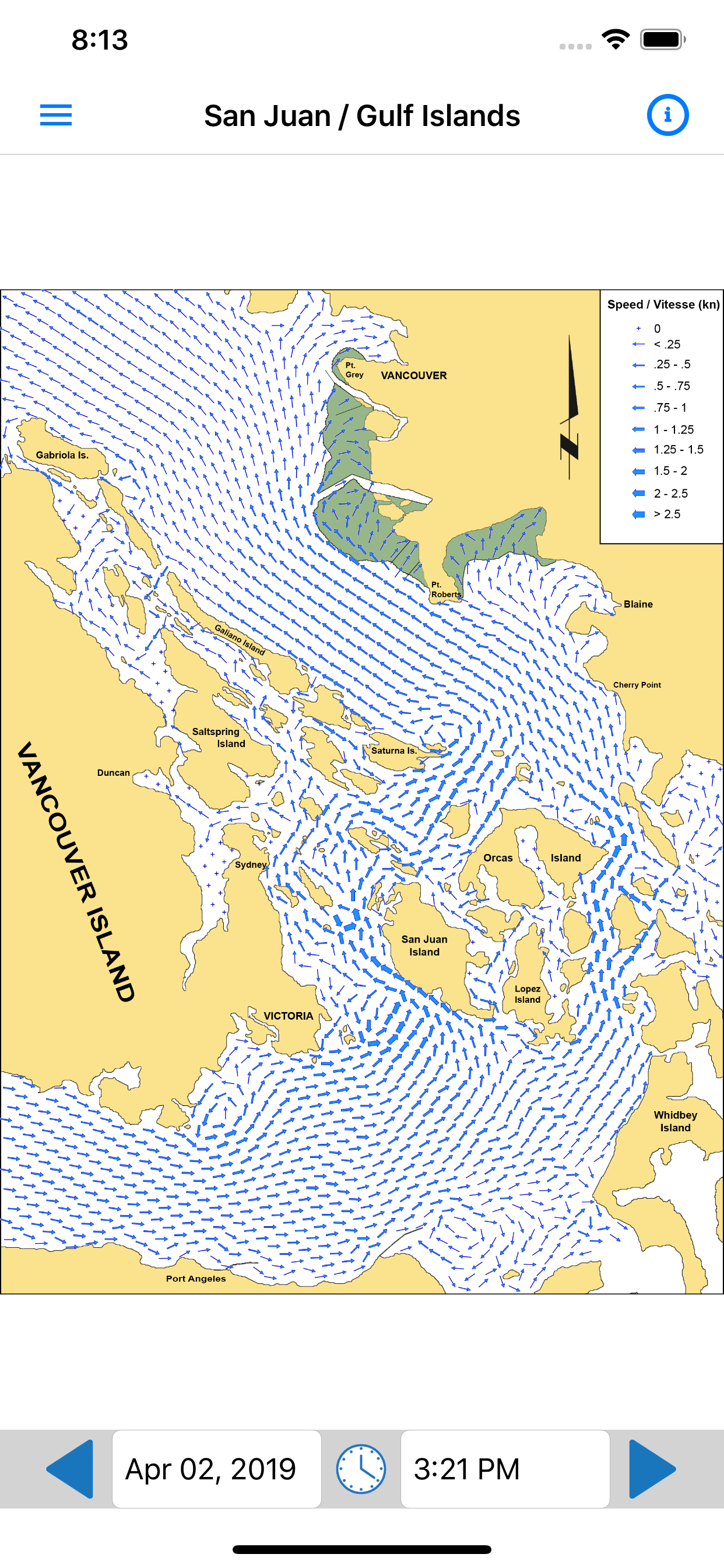
The developer does not say. Overall a good tool but a prudent mariner should cross check the physical book and annual supplement. This app is developed with data from CHS. They do not correct for DST. From observations, I suspect times are UTC + 8.
Just one page of the Current atlas. Fine for the SJI cruiser, but a rip-off compared to buying the book.
For $20, it’s a little too small. Including the full Straight of Georgia, the full Juan de Fuca, and at least to the bottom of Whidbey. Good start though.
Extend through the inside passage and I’m all in.
At one point I was using the app and I found what I thought was an error since there was a disagreement between the paper current atlas and the app. I recorded the time and the referenced pages and reached out to the author of the app. He wrote several emails explaining the additional algorithms used for the app, and how since the paper atlas is by hour is often doesn’t show small reversals and other small changes. He walked me thru the data used and how his app presents the analysis. I won’t stop referencing the paper current atlas but I will use this app as well. Randall
If you’ve ever purchased the official (paper) atlas ($30), downloaded the annual predictions and gone through the process of selecting the right atlas pages for your trip, this app is an absolute no-brainer. Based on several past experiences with the “classic” atlas, this will save me hours in the future! THANK YOU!!!
I sail a small boat in these waters, and depend on the Canadian current atlas for every trip. This implementation is fantastic. And since you have to buy an update to the printed atlas every year for $20, the once off price for the app is well worth it. The app also lets you scan the currents hourly, instead of paging through the printed guide. Very impressive.
|
Chart
|
Category
|
Rank
|
|---|---|---|
|
Top Free
|

|
134
|
|
Top Free
|

|
171
|
|
Top Free
|

|
202
|
|
Top Free
|

|
329
|
| Name | Reviews | Recent release | |
|---|---|---|---|

FishTrack - Charts & Forecasts
SST, tides, currents, & maps
|
5
|
3 months ago | |

PredictWind — Marine Forecasts
#1 in Marine Weather Forecasts
|
303
|
1 week ago | |

SailFlow: Marine Forecasts
Wind, Maps, Waves & Tides
|
155
|
1 week ago | |

NOAA Marine Weather
Wind, swell and wave forecast
|
32
|
2 days ago | |

NOAA Buoy Reports
No Nonsense Buoy Conditions
|
24
|
1 month ago | |

PredictWind Offshore Weather
Offshore Weather & Grib Viewer
|
11
|
3 months ago | |

LuckGrib
#1 for sailors and enthusiasts
|
9
|
9 months ago | |

TidesPro: Tide Charts & Tables
NOAA Tides & Marine Weather
|
16
|
3 weeks ago | |

Avy: Avalanche & Weather Info
NWAC and SAC Avy Forecasts
|
6
|
1 month ago | |

PredictCurrent
Tidal Current Maps & Tables
|
6
|
2 months ago |