
Altimeter: Elevation, Compass
Altitude Barometer GPS Tracker
#1 Keyword Rankings
Today
Top 10 Rankings
Today
Top 30 Rankings
Today
Top 100 Rankings
Today
Description
While traveling with a vehicle (car, bicycle, etc.), while hiking or climbing, you can instantly discover your location and altitude, direction, geographic coordinate, address and atmospheric pressure on the map. While following your direction on a detailed compass screen, you can also monitor the change in altitude. You can share the photos you take with your loved ones, including your altitude, geographic coordinates and address information. Depending on the shooting angle, the compass direction is also included in the photos.
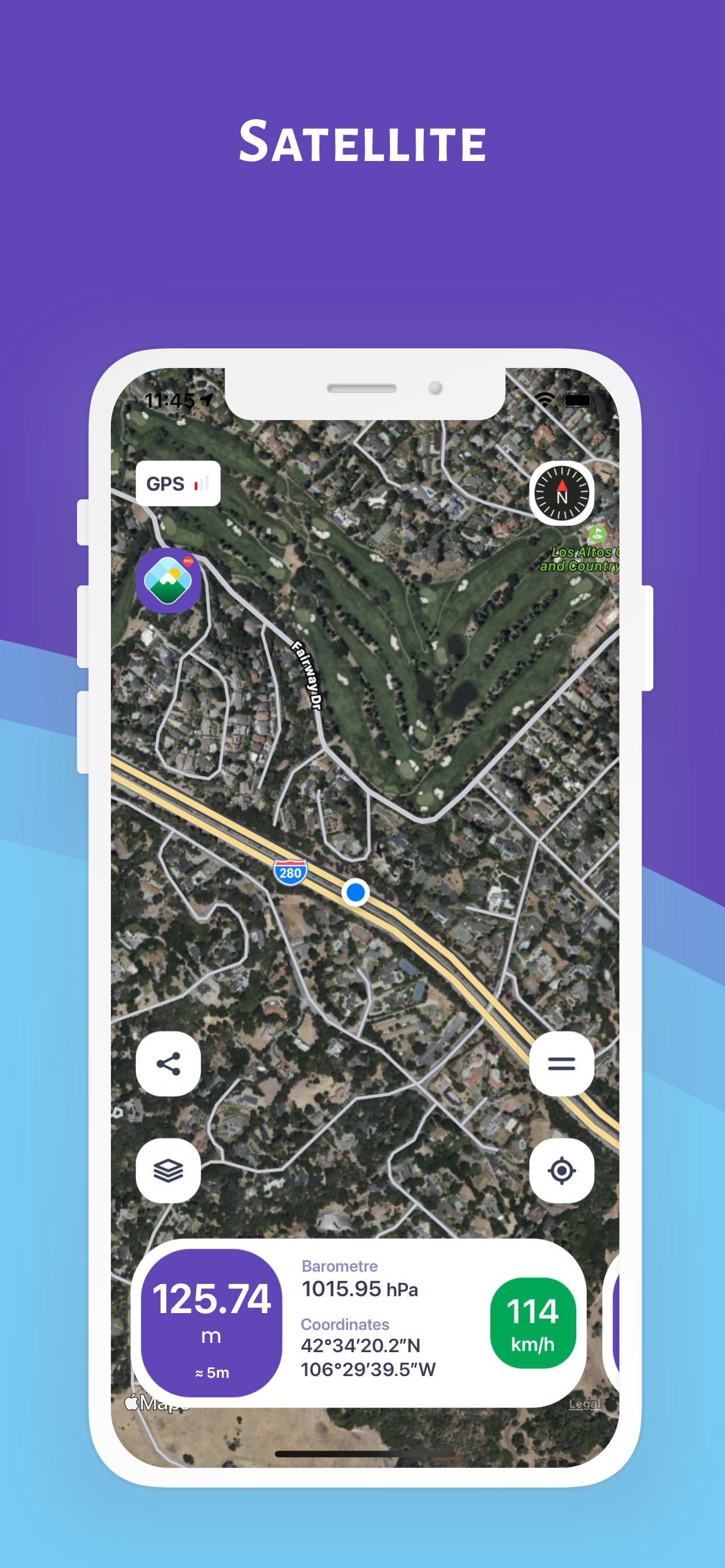
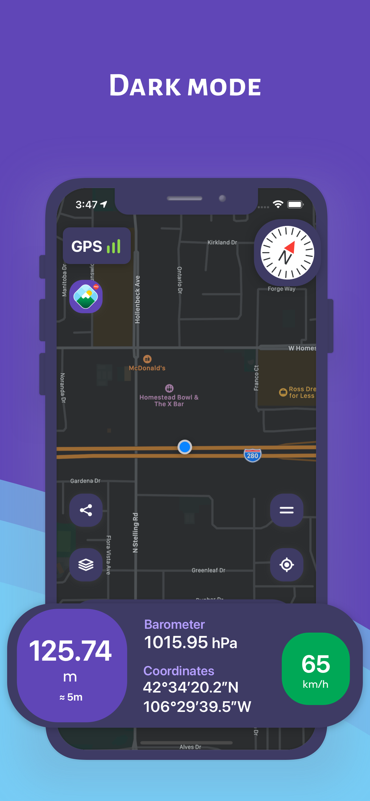
DISCOVER YOUR HEIGHT FROM SEA ON THE MAP (Normal Mode)
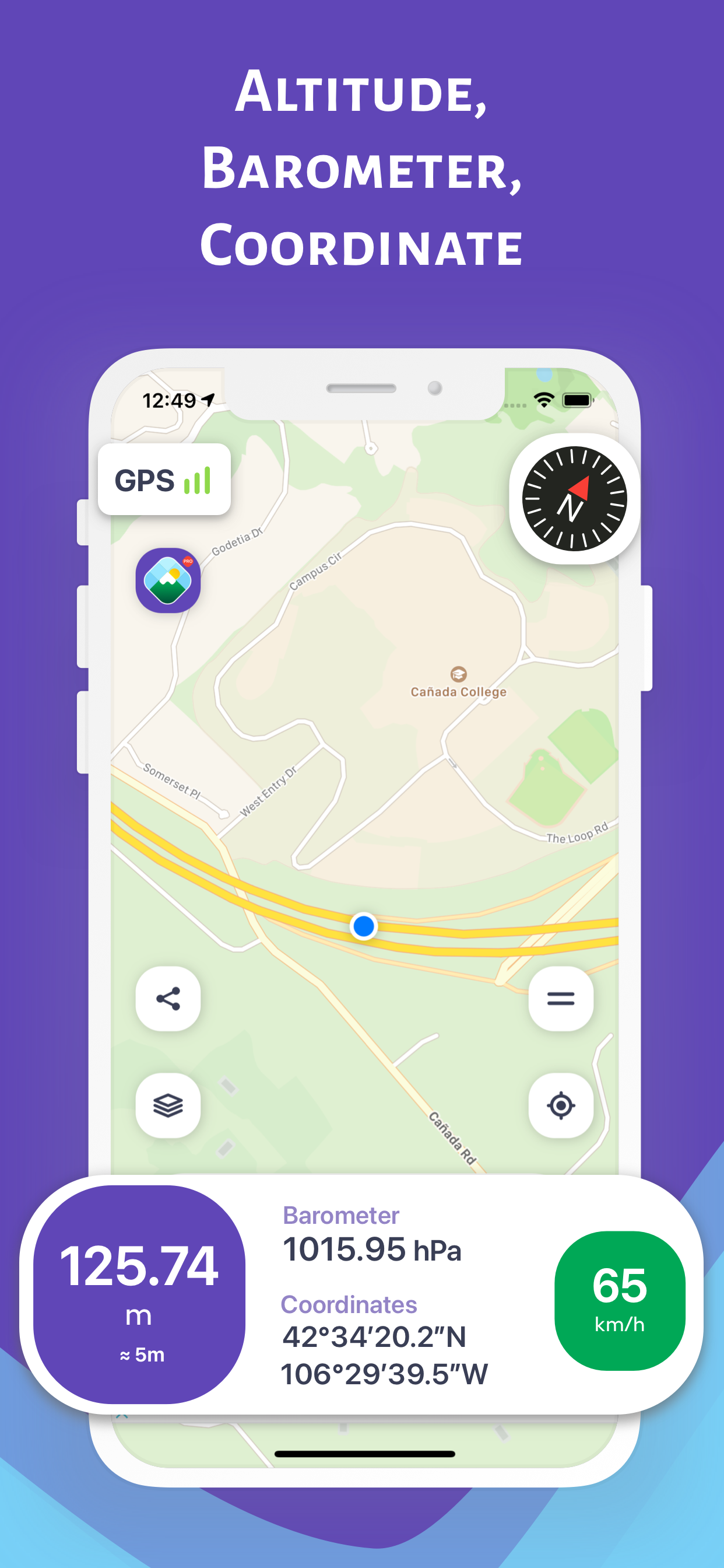
You can instantly discover the information of your location on the map
- Altitude (elevation) above sea level
- Open air (atmosphere) pressure
- Latitude and longitude coordinates and address
- Speed in motion
- Direction with a detailed compass
FOLLOW YOUR HEIGHT FROM SEA ON THE MAP ON THE MOVE (Track Mode on the Map)
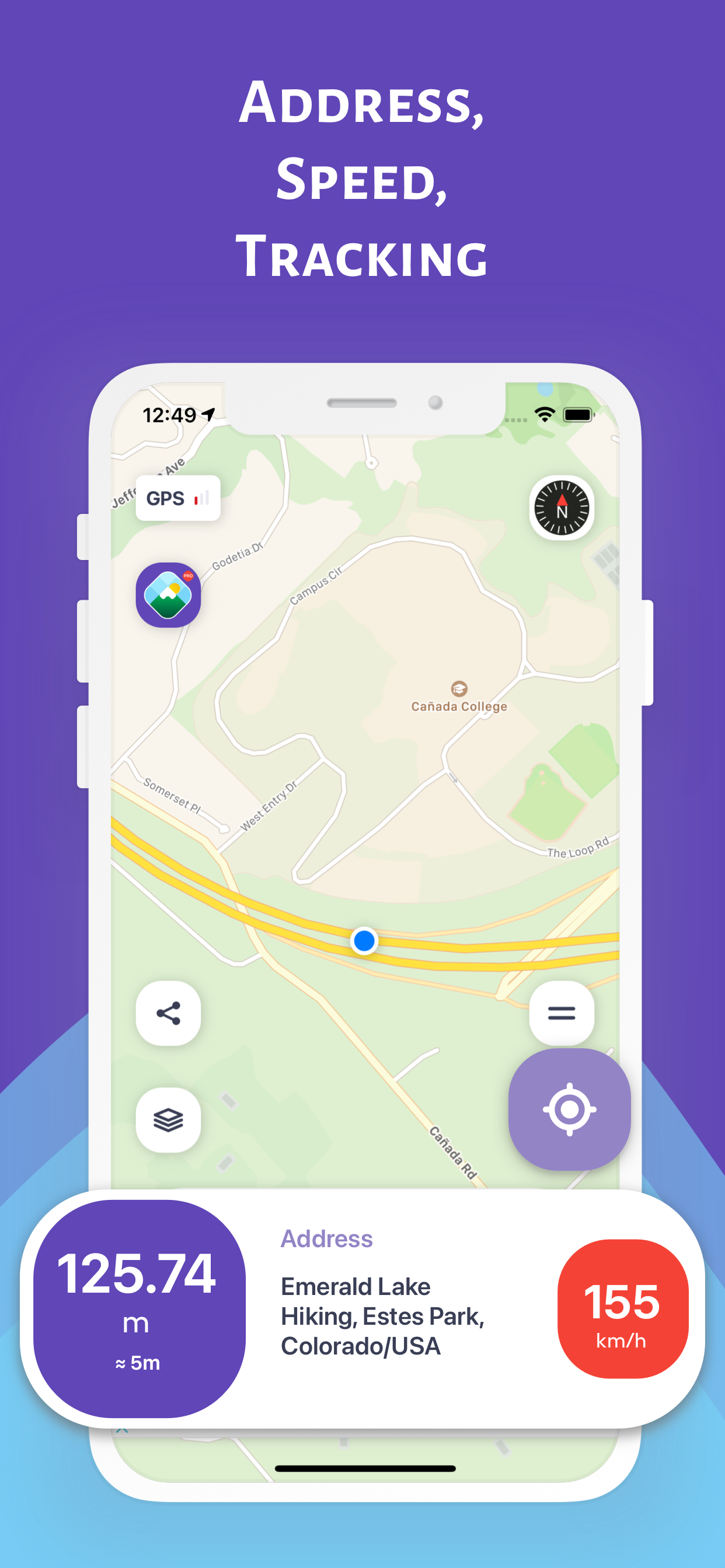
On the map when traveling in a vehicle (car, bike, etc.), hiking or climbing, you can instantly track your location and the change in information
- Altitude (elevation) above sea level
- Open air (atmosphere) pressure
- Latitude and longitude coordinates and address
- Speed in motion
- Direction with a detailed compass
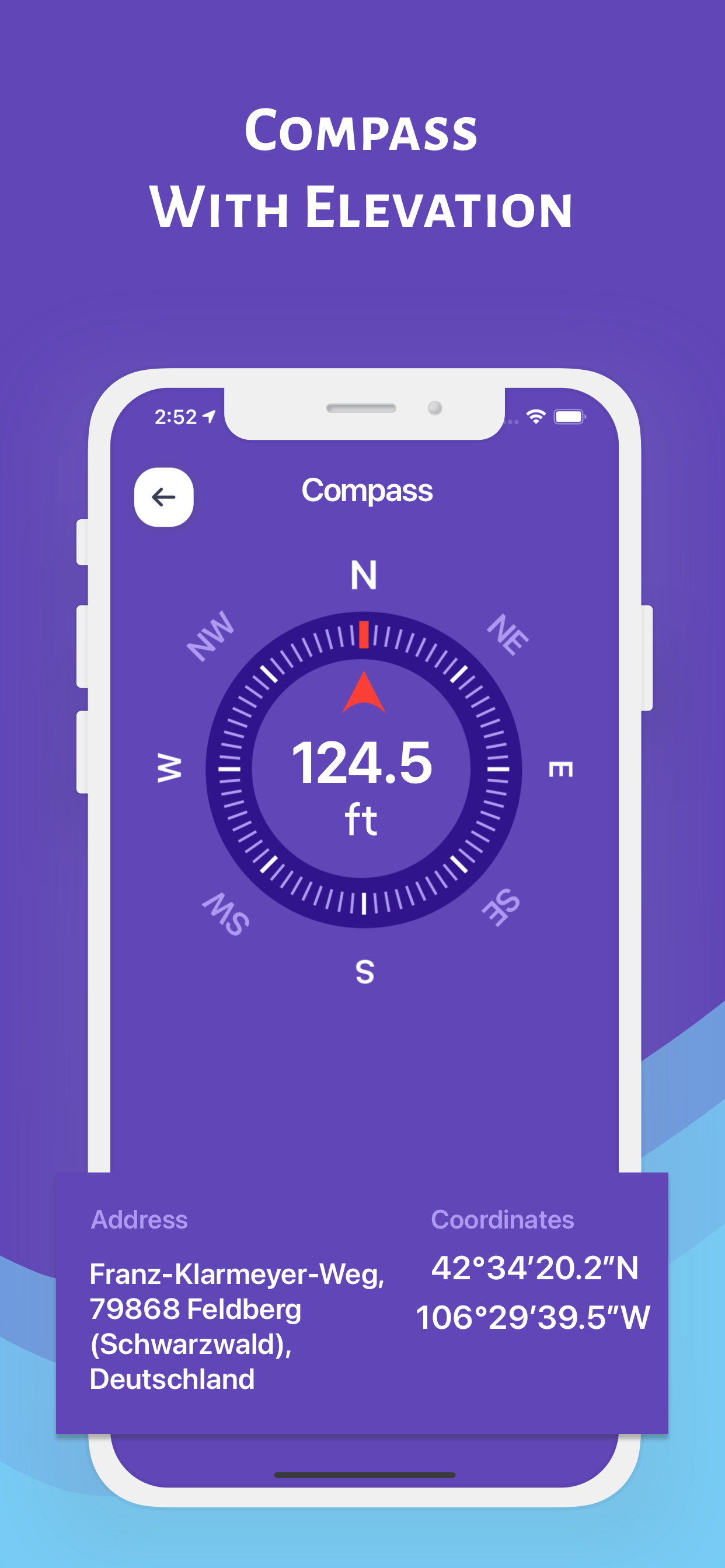
FOLLOW YOUR HEIGHT FROM SEA ON THE COMPASS (Compass Mode)
While traveling with a vehicle (car, bicycle, etc.), while taking a walk or climbing, you can instantly track your direction and the altitude of your current location
SHARE YOUR PHOTO WITH YOUR LOVED ONES WITH HEIGHT AND DIRECTION INFORMATION (Sharing Mode)
While traveling with a vehicle (car, bike, etc.), hiking or climbing, you can share the photos you have taken with this information
- Height, pressure, coordinate and address information will be on the photo
- Depending on the shooting angle, the compass direction will be added to the photo
YOU CAN ACCESS ALTITUDE AND LOCATION INFORMATION FROM APPLE WATCH
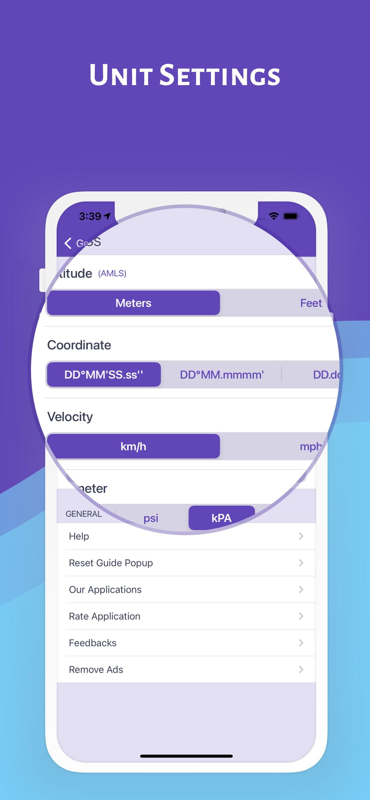
IMPORTANT REMINDER ABOUT CALCULATION METHOD AND ACCURACY
- The coordinates of the altitude and location are calculated using the GPS signals of the device used
- There may be differences in the measurement values depending on the GPS signal quality of the device's location
- Just below the height value, the accuracy value of the measurement is given instantly in meters
- Compass accuracy may be affected by magnetic or environmental interference
Hide..
Show more..
DISCOVER YOUR HEIGHT FROM SEA ON THE MAP (Normal Mode)
You can instantly discover the information of your location on the map
- Altitude (elevation) above sea level
- Open air (atmosphere) pressure
- Latitude and longitude coordinates and address
- Speed in motion
- Direction with a detailed compass
FOLLOW YOUR HEIGHT FROM SEA ON THE MAP ON THE MOVE (Track Mode on the Map)
On the map when traveling in a vehicle (car, bike, etc.), hiking or climbing, you can instantly track your location and the change in information
- Altitude (elevation) above sea level
- Open air (atmosphere) pressure
- Latitude and longitude coordinates and address
- Speed in motion
- Direction with a detailed compass
FOLLOW YOUR HEIGHT FROM SEA ON THE COMPASS (Compass Mode)
While traveling with a vehicle (car, bicycle, etc.), while taking a walk or climbing, you can instantly track your direction and the altitude of your current location
SHARE YOUR PHOTO WITH YOUR LOVED ONES WITH HEIGHT AND DIRECTION INFORMATION (Sharing Mode)
While traveling with a vehicle (car, bike, etc.), hiking or climbing, you can share the photos you have taken with this information
- Height, pressure, coordinate and address information will be on the photo
- Depending on the shooting angle, the compass direction will be added to the photo
YOU CAN ACCESS ALTITUDE AND LOCATION INFORMATION FROM APPLE WATCH
IMPORTANT REMINDER ABOUT CALCULATION METHOD AND ACCURACY
- The coordinates of the altitude and location are calculated using the GPS signals of the device used
- There may be differences in the measurement values depending on the GPS signal quality of the device's location
- Just below the height value, the accuracy value of the measurement is given instantly in meters
- Compass accuracy may be affected by magnetic or environmental interference
In-Apps
- Remove Ads
- 79.000đ
Screenshots

 User Rating
4.48 out of 5
23 ratings in Vietnam
5 star
16
4 star
4
3 star
2
2 star
0
1 star
1
Ratings History
Reviews
Store Rankings
Ranking History
Category Rankings
|
Chart
|
Category
|
Rank
|
|---|---|---|
|
Top Free
|

|
51
|
|
Top Free
|

|
101
|
|
Top Free
|

|
151
|
|
Top Free
|

|
208
|
|
Top Free
|

|
221
|
Keywords
Users may also like
| Name | Reviews | Recent release | |
|---|---|---|---|

My Altitude
GPS Elevation & Barometer
|
1
|
1 month ago | |

Travel Altimeter & Elevation
Altitude, Barometer, Sea Level
|
15
|
1 month ago | |

Terrain Radar Altimeter
Altimeter with elevation chart
|
0
|
5 months ago | |
Speedometer ⊲
Limit Alert,Speed Cam,Compass
|
7
|
10 months ago | |

My Altitude: GPS Altimeter
Find my current altitude
|
6
|
5 months ago | |

Arvento
|
0
|
1 month ago | |

My Altitude and Elevation GPS
Elevation over surface.
|
0
|
1 day ago | |
|
Elevation - Altimeter Map
Find your altitude on the map
|
1
|
2 days ago | |

i Altimeter
|
1
|
7 months ago | |

TKGM Parsel Sorgu
|
0
|
10 months ago |
Show More
Revenue and Downloads
Gain valuable insights into Rakım Ölçer: Barometre, GPS performance with our analytics. Sign up now
to
access downloads, revenue, and more.
App Info
- Category
- Navigation
- Publisher
- Furkan Ozoglu
- Languages
- German, Chinese, Spanish, French, English, Japanese, Russian, Turkish
- Recent version
- 2.0.3 (8 months ago )
- Released on
- Apr 21, 2017 (7 years ago )
- Also available in
- Turkey, France, Germany, Spain, China, United States, Australia, Japan, Switzerland, Russia, Austria, Colombia, Mexico, Canada, Chile, Belgium, Italy, Ukraine, United Kingdom, India, Malaysia, Peru, New Zealand, Indonesia, Ecuador, Philippines, Azerbaijan, Hungary, Thailand, Netherlands, Algeria, Lebanon, Romania, Vietnam, South Africa, Argentina, Saudi Arabia, Egypt, Portugal, Kazakhstan, Pakistan, Brazil, Taiwan, Ireland, Israel, Sweden, Dominican Republic, Greece, Poland, United Arab Emirates, Nigeria, Czechia, Norway, Hong Kong, Singapore, Denmark, Belarus, South Korea, Kuwait, Finland
- Last updated
- 2 days ago