beste 3d karte mit super hoher auflösung
etwas mehr layer wären ganz schön und am anfang wars etwas unübersichtlich für mich.


Yes, RealityMaps is free to download, however it contains in-app purchases or subscription offerings.
🤔 The RealityMaps app's quality is mixed. Some users are satisfied, while others report issues. Consider reading individual reviews for more context.
RealityMaps has several in-app purchases/subscriptions, the average in-app price is €18.32.
To get estimated revenue of RealityMaps app and other AppStore insights you can sign up to AppTail Mobile Analytics Platform.

4.51 out of 5
175 ratings in Austria
etwas mehr layer wären ganz schön und am anfang wars etwas unübersichtlich für mich.
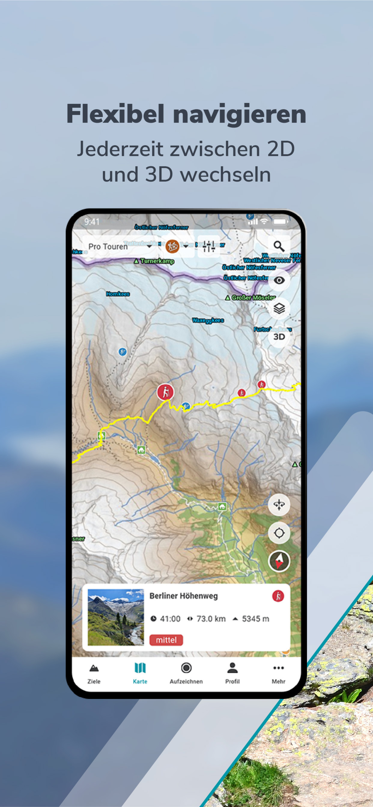
Fatmap ist eine sehr brauchbare App für Skianwendungen zur Alternative von Fatmap. Das Kartenmaterial ist um einiges hochwertiger. Hangneigungslayer gibst es auch. Das Distanznetz und die Hanglagenexposition sind nicht in Reality Maps enthalten.
Einfach genial und wird immer besser😎🇦🇹
Da ich mir bezüglich Orientierung im Gelände mit 2D-Karten immer sehr schwer getan habe (mein Orientierungssinn war immer eine meiner größten Schwächen) hat mir Reality Maps durch die detailgetreue 3D-Darstellung unheimlich geholfen. Die Funktion Virtuelles Panorama ist für mich eines der genialsten Features, das ich je gesehen habe und durch vielseitige Tracking-Funktionen und mittlerweile weiter ausgebautem Kartenmaterial in 3D und auch 2D bin ich mit der Pro-Version dieser App vollauf zufrieden. Bitte macht weiter so eine exzellente Arbeit! Sportliche Grüße Christoph
Die App stürzt andauernd ab. Bezahlte Premiumversion nicht vorhanden. Support schiebt diese Thematik auf den App Store, also keine große Hilfe!
Hätte mir bessere Topologie Karten erwartet.... bietet sonst aber auch keiner an ... Abgesehen von Alpenvereinskarten (österreichische AV) ... nur in Papier ! Also.... Neue Challenge: „Topolinien 5m “ .... oder gleich Lidar .... dafür wär ich gerne bereit, “Etwas” mehr zu bezahlen !!
Update: Seit einiger Zeit, etwa ein Jahr, bekomme ich meine BEZAHLTE REGION Wilder Kaiser nur noch als Matsch zu sehen. Hat die Karte eigentlich noch nie wirklich gut funktioniert, ist nun die Umgebungskarte, die eigentlich nicht detailliert ist, um ein tausendfaches detaillierter als die dann geladene Region. Diese besteht dann bildschirmfüllend aus etwa vier bis sechs farbigen Flächen! Wenn man Glück hat findet man durch drehen der 3D Ansicht eine Perspektive die die detaillierte Karte sichtbar macht, einen Millimeter zu weit gedreht hat man wieder Matsch. Ein einfarbiges Aquarelle eines Dreijährigen weist mehr Details auf als diese "Karte". Man würde meinen man bekommt eine detaillierte Karte auf der alle Gipfel und alle Wege eingezeichnet sind. Leider sind bspw im Kaisergebirge nur eine Handvoll Gipfel eingezeichnet. Nicht einmal die Wichtigsten! Dafür aber Andere die so unwichtig sind das man sie nicht einmal kennt! Die 3D Funktion ist gut, ähnlich wie GogglEarth, aber detaillierter, nur ohne eingezeichnete Gipfel nur bedingt nutzbar. In den vorgegebenen Touren kommen Gipfel vor die wie gesagt nicht eingezeichnet sind und man muss ihre genaue Position erraten. Eine Suchfunktion sucht man vergebens, jedoch bei den paar eingezeichneten Gipfeln wäre dies ohnehin ein bisschen übertrieben. Beim Scrollen seitwärts blendet sich ständig das Menü ein und beim Drehen der Karte macht sie unkontrollierte Sprünge sodass man nicht mehr weiß wo man umgeht. Wenn man seine GPS Position sucht steht da das man gefunden wurde jedoch wird einem seine Position nicht angezeigt. Wenn man die Karte eine Zeit lang nicht benützt muss man beim nächsten Mal wenn man sie anwirft alles wieder von Neuem runterladen. Diese Karte ist nicht nur Sauteuer sondern auch völlig nutzlos und kostet viele Nerven bevor man es dann doch in Erwägung zieht diesen Dreck wieder zu löschen. Alles in Allem hätte ich gern mein Geld zurück wenn nicht evtl ein Update kommt in dem Dinge berücksichtigt werden um diese Karte auch wirklich nutzen zu können.
Ausgezeichnete App, sehr gute Auflösung beispielsweise alter Dolomiten Steige. Die Norditalien Abdeckung der Satelliten Bilder könnte allerdings noch ausgebaut werden. Und was definitiv noch fehlt ist Frankreich (zB Provence, Südfrankreich, Luberon) und Spanien (zB Pyrenäen, aber auch Kanaren, insbesondere Santa Cruz de La Palma, Teneriffa - Teide National Park). Das wäre noch super. Die Abo Lösung ist auf jeden Fall fair gepreist. Schön auch die Integration von Rother Touren, elegant gelöst.
Sensationell gut gelungen. Wir sind nie mehr ohne den interaktiven 3D Karten im Gelände unterwegs. Eine Pflicht für alle umsichtigen Bergsteiger.
Da fehlen von halb Österreich die Karten, was soll das??
|
Chart
|
Category
|
Rank
|
|---|---|---|
|
Top Grossing
|

|
78
|
|
Top Grossing
|

|
80
|
|
Top Free
|
|
185
|
|
Top Free
|

|
298
|
|
Top Free
|

|
317
|
