RouteMyPhotos
#1 Keyword Rankings
Today
Top 10 Rankings
Today
Top 30 Rankings
Today
Top 100 Rankings
Today
Description
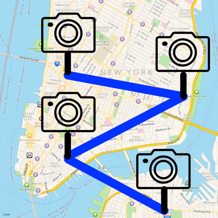
RouteMyPhotos enables you to recreate a journey you took using the photos you took on that journey.
Plotting photos on your map requires photos that have geolocation data embedded in their metadata. Photos taken on your device will have geolocation data if you permitted the camera to record where they were taken.
Interested in knowing where and how far you have traveled but do not want to waste battery power running your device’s GPS? Just take a photo at key points in your journey and RouteMyPhotos will plot on a map the location of those photos and create a path with distance traveled between those photos. You can then view a slideshow of the photos in your route by tapping the photo attached to a location.
Simply choose any photo album or moment, and all the photos in that selected album or moment will be plotted on a map in the order you took those photos. Then tap on the routing button to create a path connecting those photos with the distances between the photos being automatically calculated.
Features:
▪ Plot all the photos (with geolocation data) in a photo album or moment on a map.
▪ Plot a path between these photos and calculate the distance traveled without using the internet.
▪ Lookup the address of a photo (this requires internet connection).
▪ Show the location of a photo in Apple or Google (if installed) maps. Use this feature to generate directions to the location of a photo.
▪ View a slideshow of any album or photo album.
▪ Export a KML file containing the photo locations than can be imported into Google Earth or Google Maps.
Hide..
Show more..
Plotting photos on your map requires photos that have geolocation data embedded in their metadata. Photos taken on your device will have geolocation data if you permitted the camera to record where they were taken.
Interested in knowing where and how far you have traveled but do not want to waste battery power running your device’s GPS? Just take a photo at key points in your journey and RouteMyPhotos will plot on a map the location of those photos and create a path with distance traveled between those photos. You can then view a slideshow of the photos in your route by tapping the photo attached to a location.
Simply choose any photo album or moment, and all the photos in that selected album or moment will be plotted on a map in the order you took those photos. Then tap on the routing button to create a path connecting those photos with the distances between the photos being automatically calculated.
Features:
▪ Plot all the photos (with geolocation data) in a photo album or moment on a map.
▪ Plot a path between these photos and calculate the distance traveled without using the internet.
▪ Lookup the address of a photo (this requires internet connection).
▪ Show the location of a photo in Apple or Google (if installed) maps. Use this feature to generate directions to the location of a photo.
▪ View a slideshow of any album or photo album.
▪ Export a KML file containing the photo locations than can be imported into Google Earth or Google Maps.
Screenshots


 User Rating
0 out of 5
0 ratings in Czechia
Ratings History
Reviews
App doesn't have any reviews yet
Store Rankings
Ranking History
App Ranking History not available yet
Category Rankings
|
Chart
|
Category
|
Rank
|
|---|---|---|
|
Top Paid
|

|
50
|
|
Top Paid
|

|
67
|
|
Top Paid
|

|
142
|
|
Top Paid
|

|
152
|
|
Top Paid
|

|
206
|
Keywords
Users may also like
| Name | Reviews | Recent release | |
|---|---|---|---|

Jauntlet Travel Blog & Journal
Trip Map, Photos and Locations
|
0
|
2 years ago | |

MapPath Pro
GPS Tracker, Map Measure Tool
|
0
|
9 months ago | |

gps4camera
Photo Geo Tag Helper
|
0
|
3 years ago | |

Best Route Optimizer Pro
Planning multiple stops
|
0
|
3 years ago | |

Maryland Roads Traffic
Traffic News & Video Cameras
|
0
|
2 years ago | |

smartRV
Control your smartRVcontrols!
|
0
|
3 weeks ago | |

CS Mapping
Interactive map
|
0
|
1 month ago | |

TruckPatrol
|
0
|
1 year ago | |

Florida Inside
Reisetipps für Florida
|
0
|
2 weeks ago | |

Dorchester County Audio Tours
An OnCell App
|
0
|
5 months ago |
Show More
Revenue and Downloads
Gain valuable insights into RouteMyPhotos performance with our analytics. Sign up now
to
access downloads, revenue, and more.
App Info
- Category
- Navigation
- Publisher
- John Kearon
- Languages
- French, German, English, Chinese, Spanish
- Recent version
- 1.8.5 (4 years ago )
- Released on
- Dec 21, 2015 (8 years ago )
- Also available in
- Taiwan, United Kingdom, Philippines, United Arab Emirates, Italy, Japan, South Korea, Kuwait, Kazakhstan, Lebanon, Mexico, Malaysia, Nigeria, Netherlands, New Zealand, Peru, India, Pakistan, Portugal, Romania, Russia, Saudi Arabia, Sweden, Singapore, Thailand, Turkey, United States, Vietnam, South Africa, Germany, Argentina, Austria, Australia, Azerbaijan, Belgium, Brazil, Belarus, Canada, Switzerland, Chile, China, Colombia, Czechia, Israel, Denmark, Dominican Republic, Algeria, Ecuador, Egypt, Spain, Finland, France, Greece, Hong Kong, Hungary, Indonesia, Ireland, Poland, Norway, Ukraine
- Last updated
- 3 weeks ago