
SkyCharts XC EFB
Geo plates and charts
#1 Keyword Rankings
Today
Top 10 Rankings
Today
Top 30 Rankings
Today
Top 100 Rankings
Today
Description
Current and valid FAA&AISWEB aviation charts updated every 28 days, including approach plates! Includes basic international airport data from ourairports.net and openAIP.net.
Due to no freely avialable charts, please note that for charts outside of USA&Brazil non current ONC/VFR with a current openAIP overlay is available, but NO IFR charts or plates are available.
Includes a free 30 day trial!
If you wish to continue using SkyCharts after the trial, please purchase a $3.99/month subscription. Note that buying a subscription does not unlock any additional features.
See full description regarding auto-renewing subscriptions, privacy policy and EULA below.
For USA/Alaska, the application has all current FAA VFR (sectional+WAC), IFR (High and Low), TAC, FLY (flip side of TAC chart), Helicopter, Gulf Coast WAC, Gulf Of Mexico, and Wall aviation charts.
Grand Canyon charts are included in the TAC charts, and Bahamas and Mexico as WAC charts.
Brazil has VFR, IFR (High and Low) and approach plates.
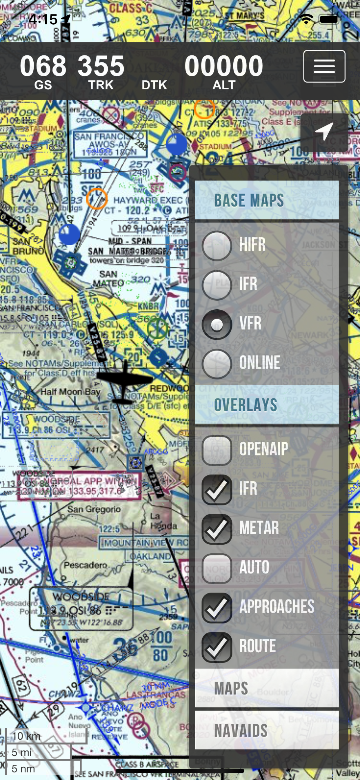
Also included is a METAR/TAF overlay, and an IFR overlay to view routes on top of VFR charts.
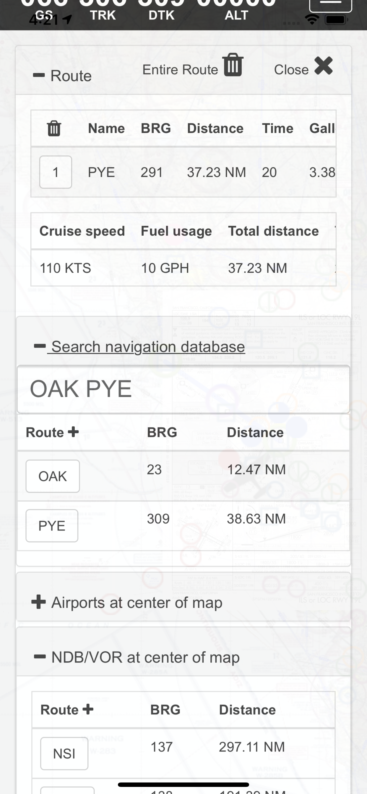
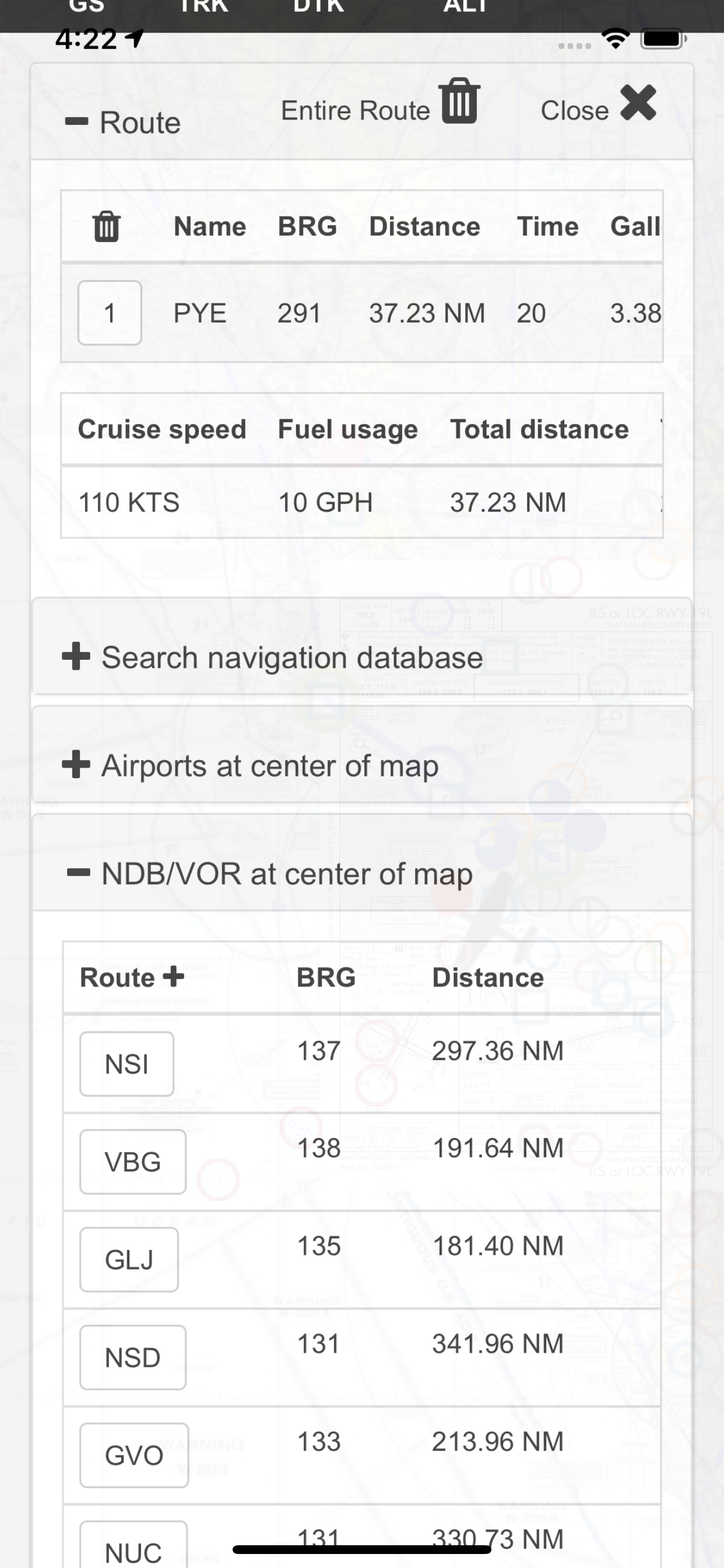
Its very easy to create and modify routes directly on the map or by drag&drop in table.
Navigation readout is configurable to fit exactly what you want to see. It also has a nifty auto-layout feature that selects fields for you in both portrait and landscape mode.
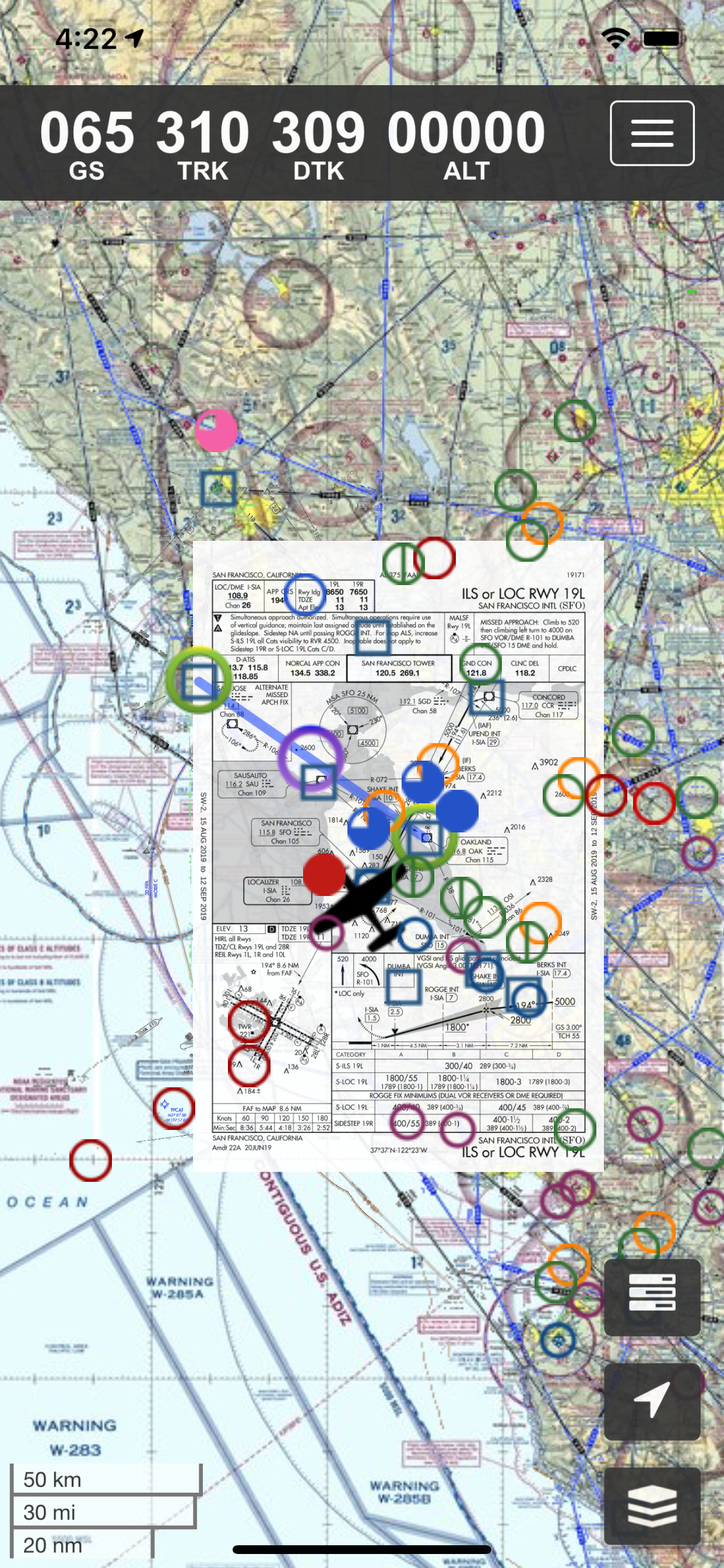
DOUBLE TAP on map to view A/FD and approach plates.
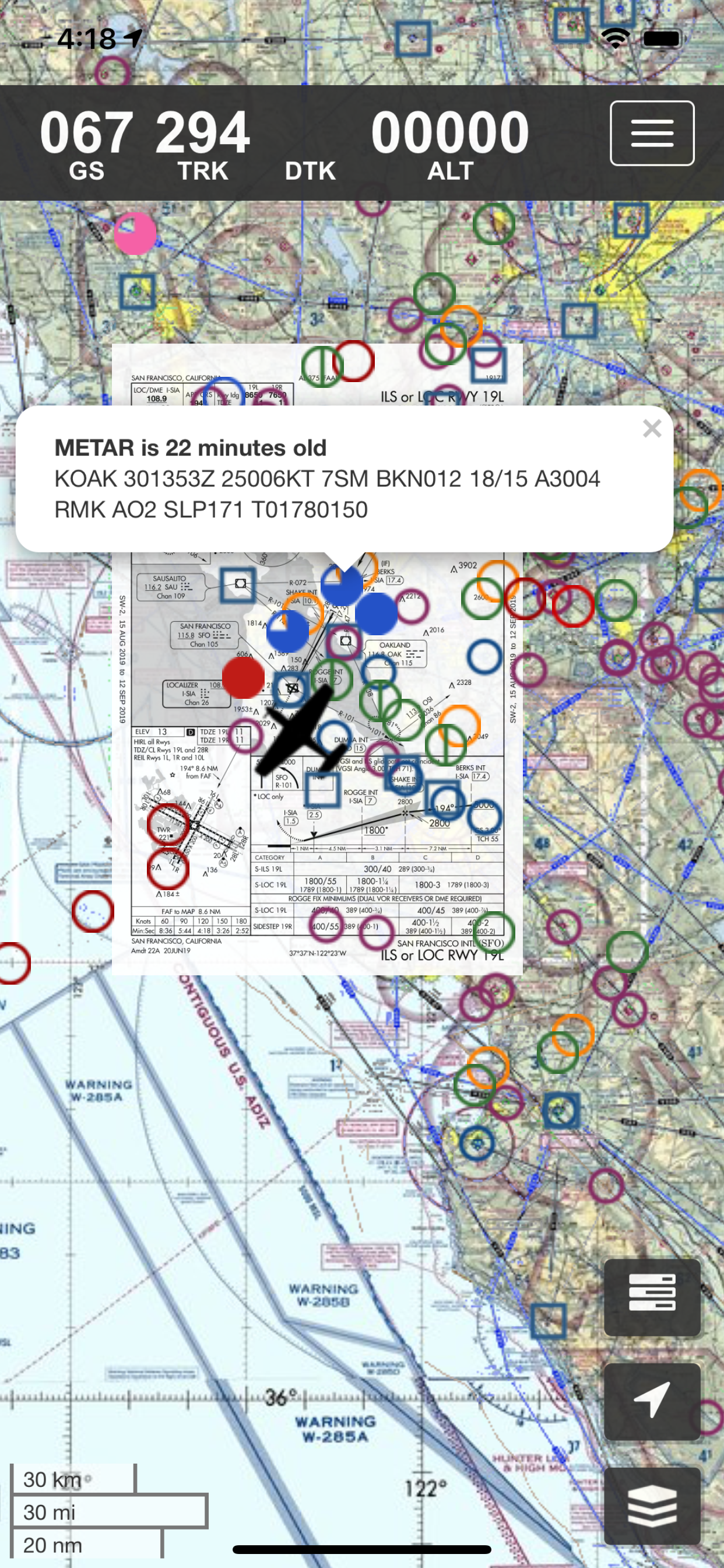
Map has VFR/IFR/LIFR color-coded weather METARs, with orange TAFs.
SUA (Special Use Airspace) information is also available.
Download charts and plates for offline usage.
Features:
* Fast zoom/scroll of included charts using standard gestures.
* Allows download of charts for offline usage. Charts are selected on a region basis.
* Navigation computes GS, TRK, DTK, DIS & ETE to final waypoint.
* METAR/TAF color coded dots according to ADDS: http://www.skycharts.net/?page_id=421
* Double tap on airport to select A/FD and TPPs/IAPs to view.
* Huge built-in navigation database, with all 20,000 airports, 45,000 FAA IFR/VFR navigation fixes and 2,100 FAA VOR/ADF fixes.
For more information, please see the webpage at
http://www.skycharts.net
The monthly subscription of SkyCharts XC aviation data of $3.99 is auto-renewed. Payment will be charged to your iTunes/App Store account at confirmation of purchase. You can turn off auto-renew at any time from your iTunes/App Store account settings, but you must do so at least 24 hours before the end of the current subscription period to avoid being billed for the next cycle. No cancellation of the current subscription is allowed during the active period. Any unused portion of a free trial period will be forfeited when you purchase a subscription to SkyCharts XC.
The privacy policy and EULA can be found here:
http://www.skycharts.net/?page_id=1465
For fast response to all questions, comments or suggestions, please email [email protected]
Hide..
Show more..
Due to no freely avialable charts, please note that for charts outside of USA&Brazil non current ONC/VFR with a current openAIP overlay is available, but NO IFR charts or plates are available.
Includes a free 30 day trial!
If you wish to continue using SkyCharts after the trial, please purchase a $3.99/month subscription. Note that buying a subscription does not unlock any additional features.
See full description regarding auto-renewing subscriptions, privacy policy and EULA below.
For USA/Alaska, the application has all current FAA VFR (sectional+WAC), IFR (High and Low), TAC, FLY (flip side of TAC chart), Helicopter, Gulf Coast WAC, Gulf Of Mexico, and Wall aviation charts.
Grand Canyon charts are included in the TAC charts, and Bahamas and Mexico as WAC charts.
Brazil has VFR, IFR (High and Low) and approach plates.
Also included is a METAR/TAF overlay, and an IFR overlay to view routes on top of VFR charts.
Its very easy to create and modify routes directly on the map or by drag&drop in table.
Navigation readout is configurable to fit exactly what you want to see. It also has a nifty auto-layout feature that selects fields for you in both portrait and landscape mode.
DOUBLE TAP on map to view A/FD and approach plates.
Map has VFR/IFR/LIFR color-coded weather METARs, with orange TAFs.
SUA (Special Use Airspace) information is also available.
Download charts and plates for offline usage.
Features:
* Fast zoom/scroll of included charts using standard gestures.
* Allows download of charts for offline usage. Charts are selected on a region basis.
* Navigation computes GS, TRK, DTK, DIS & ETE to final waypoint.
* METAR/TAF color coded dots according to ADDS: http://www.skycharts.net/?page_id=421
* Double tap on airport to select A/FD and TPPs/IAPs to view.
* Huge built-in navigation database, with all 20,000 airports, 45,000 FAA IFR/VFR navigation fixes and 2,100 FAA VOR/ADF fixes.
For more information, please see the webpage at
http://www.skycharts.net
The monthly subscription of SkyCharts XC aviation data of $3.99 is auto-renewed. Payment will be charged to your iTunes/App Store account at confirmation of purchase. You can turn off auto-renew at any time from your iTunes/App Store account settings, but you must do so at least 24 hours before the end of the current subscription period to avoid being billed for the next cycle. No cancellation of the current subscription is allowed during the active period. Any unused portion of a free trial period will be forfeited when you purchase a subscription to SkyCharts XC.
The privacy policy and EULA can be found here:
http://www.skycharts.net/?page_id=1465
For fast response to all questions, comments or suggestions, please email [email protected]
In-Apps
- Monthly subscription to current aviation data.
- S/ 12.90
Screenshots


 User Rating
0 out of 5
0 ratings in Peru
Ratings History
Reviews
App doesn't have any reviews yet
Store Rankings
Ranking History
App Ranking History not available yet
Category Rankings
|
Chart
|
Category
|
Rank
|
|---|---|---|
|
Top Grossing
|

|
62
|
|
Top Grossing
|

|
71
|
|
Top Grossing
|

|
84
|
Keywords
Users may also like
| Name | Reviews | Recent release | |
|---|---|---|---|

FlyQ EFB
|
0
|
2 months ago | |

Direct-To Aviation GPS VFR IFR
Air Navigation for Pilots
|
1
|
1 week ago | |

Airmate
Flight planning/weather
|
0
|
6 days ago | |

SkyDemon
|
0
|
1 week ago | |

Air Navigation Pro
The Pilot Assistant
|
11
|
1 day ago | |

AeroChart
Aeronautical Charts
|
0
|
3 months ago | |

WingX
Aviation Moving Map & Weather
|
0
|
1 month ago | |

FlyGo Air Navigation
Aviation App for Pilots
|
0
|
1 month ago | |

AirNav FBO
|
0
|
1 year ago | |

Navigraph Charts
|
1
|
3 weeks ago |
Show More
Revenue and Downloads
Gain valuable insights into SkyCharts XC EFB performance with our analytics. Sign up now
to
access downloads, revenue, and more.
App Info
- Category
- Navigation
- Publisher
- SkyCharts LLC
- Languages
- English
- Recent version
- 5.5.0 (7 months ago )
- Released on
- Sep 27, 2016 (7 years ago )
- Also available in
- Sweden, Pakistan, Italy, Japan, South Korea, Kuwait, Kazakhstan, Lebanon, Mexico, Malaysia, Nigeria, Netherlands, Norway, New Zealand, Peru, Philippines, India, Poland, Portugal, Romania, Russia, Saudi Arabia, Singapore, Thailand, Turkey, Taiwan, Ukraine, United States, Vietnam, South Africa, Dominican Republic, Argentina, Austria, Australia, Azerbaijan, Belgium, Brazil, Belarus, Canada, Switzerland, Chile, Colombia, Czechia, Germany, Denmark, United Arab Emirates, Algeria, Ecuador, Egypt, Spain, Finland, France, United Kingdom, Greece, Hong Kong, Hungary, Indonesia, Ireland, Israel
- Last updated
- 2 weeks ago