
StraboSpot2
#1 Keyword Rankings
Today
Top 10 Rankings
Today
Top 30 Rankings
Today
Top 100 Rankings
Today
Description
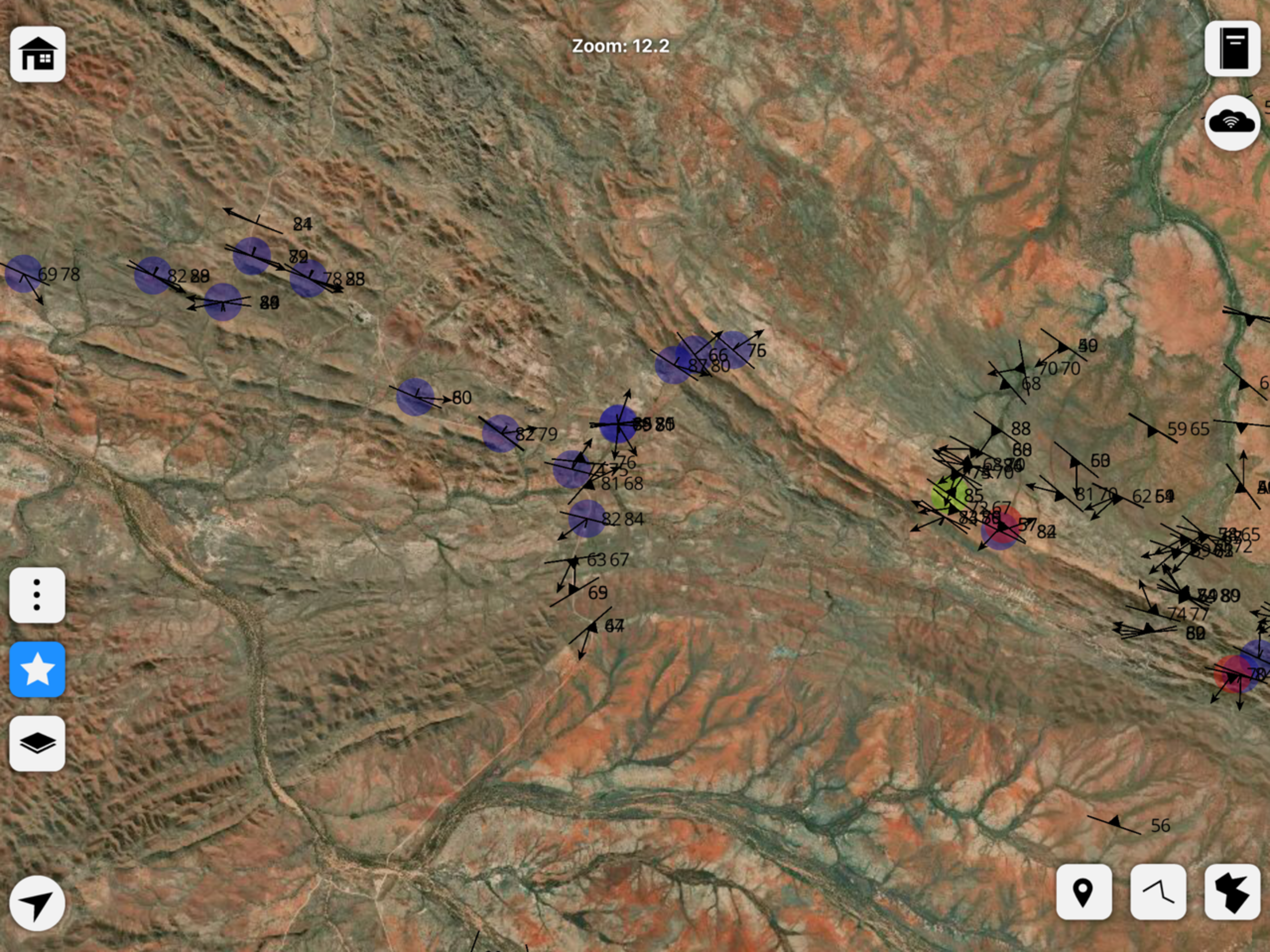
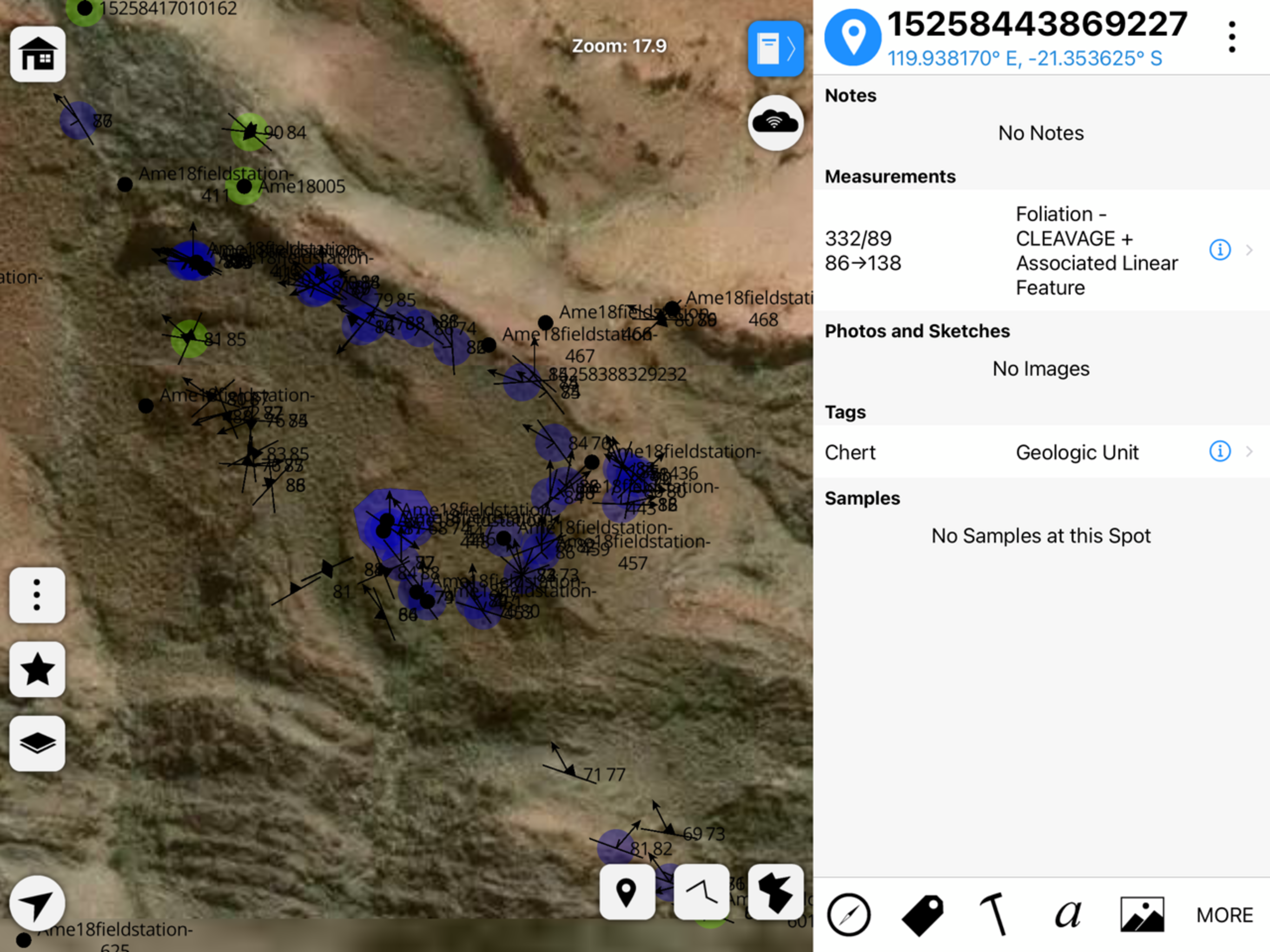
StraboSpot2 is a sophisticated tool for collecting data during geological fieldwork. Data are organized spatially into Spots or conceptually using Tags. A spot is a point, line, or polygon that contains geologic data. Spots can be spatially referenced by your device’s GPS, Drawn manually onto the map, or can be referenced on images that you take in the field. Tags are flexible data or interpretations that apply to many spots over a varied spatial extent. Examples of tags are geologic units, metamorphic grade, or fold generations.
StraboSpot2 integrates with the StraboSpot digital data system, an open-source database for field geologic data funded by the National Science Foundation. All data collected in StraboSpot2 can be easily uploaded to your Strabospot.org account, or it can be exported locally to your device’s file system.
You can add custom basemaps or overlays to your StraboSpot2 project using the StraboSpot My Maps tool at strabospot.org, mapwarper, or MapBox Studio. Custom basemaps as well as the built in basemaps can be downloaded for offline use.
Hide..
Show more..
StraboSpot2 integrates with the StraboSpot digital data system, an open-source database for field geologic data funded by the National Science Foundation. All data collected in StraboSpot2 can be easily uploaded to your Strabospot.org account, or it can be exported locally to your device’s file system.
You can add custom basemaps or overlays to your StraboSpot2 project using the StraboSpot My Maps tool at strabospot.org, mapwarper, or MapBox Studio. Custom basemaps as well as the built in basemaps can be downloaded for offline use.
Screenshots


 User Rating
0 out of 5
0 ratings in Hungary
Ratings History
Reviews
App doesn't have any reviews yet
Store Rankings
Ranking History
App Ranking History not available yet
Category Rankings
App is not ranked yet
Keywords
Users may also like
| Name | Reviews | Recent release | |
|---|---|---|---|

Emlid Flow
Reach companion app
|
1
|
3 weeks ago | |

VuSitu
Water Quality & Water Level
|
0
|
2 weeks ago | |
Coordinates Lite
|
0
|
1 year ago | |

CrowdMag
|
0
|
1 month ago | |
REF TEK Recorder Setup
|
0
|
2 years ago | |

Coordinate Master
|
0
|
1 year ago | |

Birefringence
Michel-Lévy Color Chart
|
0
|
2 years ago | |

Outcropedia
|
0
|
2 years ago | |

Bad Elf Flex
Utility for Flex GNSS receiver
|
0
|
7 months ago | |

NVS Tsunami Evacuation
|
0
|
1 year ago |
Show More
Revenue and Downloads
Gain valuable insights into StraboSpot2 performance with our analytics. Sign up now
to
access downloads, revenue, and more.
App Info
- Category
- Utilities
- Publisher
- The University of Kansas
- Languages
- English
- Recent version
- v2.5.2 (1 month ago )
- Released on
- May 4, 2021 (3 years ago )
- Also available in
- United States, Italy, Mexico, Canada, Chile, Pakistan, Romania, Japan, Kazakhstan, Malaysia, Nigeria, Netherlands, Norway, Peru, India, Saudi Arabia, Sweden, Singapore, Turkey, Ukraine, South Africa, Algeria, Austria, Australia, Belgium, Brazil, Switzerland, China, Colombia, Germany, Dominican Republic, Argentina, Egypt, Finland, France, United Kingdom, Greece, Hungary, Indonesia, Lebanon, South Korea, Azerbaijan
- Last updated
- 2 weeks ago